1920s Maps of Corpus Christi, Texas
Explore 5 historic maps of Corpus Christi from the 1920s. These maps offer a rare glimpse into what life looked like during the 1920s — showing old roads, neighborhoods, homes, and landmarks that have changed or disappeared over time.
Whether you're researching your family's past, planning a metal detecting trip, or studying how Corpus Christi's landscape evolved across the 1920s, these high-resolution maps are a powerful tool for exploring the history of this region.
- Focus on a specific era: All maps on this page are from the 1920s, giving you a focused view of this time period.
- See what’s changed: Compare century-old streets, trails, and buildings to today's modern landscape using overlays and satellite layers.
- Research with precision: Use these maps for genealogy, historical research, land use analysis, or educational projects.
- View, download, or print: Maps are fully viewable online in high resolution, and can be downloaded or printed for your own records.
Start exploring Corpus Christi's history through authentic maps from the 1920s. This is your window into the past.
Corpus Christi, TX maps
(5)- 1924 Map of Petronilla
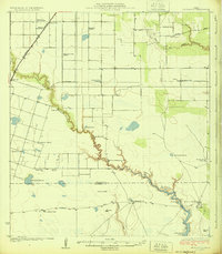 1924 Petronilla1924 Print · USGSCoastal Texas ranching and cotton farming come to life in the twenties as rail lines connected these plains to wider markets. Trace family lands and rural school sites like Norwood School alongside cattle operations at Ratamosa Ranch and Santa Cruz Ranch.2 unique versions available
 - 1925 Map of Robstown
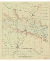 1925 Robstown1925 Print · USGSCoastal Texas near the Nueces River delta was a landscape of rail junctions and riverine wetlands during the mid-1920s. Genealogists can locate family landmarks like Ward 1 School or trace the early development of Robstown and Nuecestown.3 unique versions available
 - 1925 Map of Aransas Pass
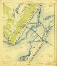 1925 Aransas Pass1925 Print · USGSThe Texas Gulf Coast comes to life in the mid-1920s, showing the early railroad developments and barrier island geography of the coastal bend. Trace the original footprints of Aransas Pass, the Aransas Pass Lighthouse, and local landmarks like Mc Campbell School.3 unique versions available
 - 1925 Map of Oso Creek
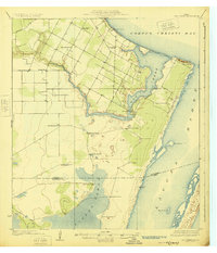 1925 Oso Creek1925 Print · USGSThe Texas coastline near Corpus Christi is captured in the mid-1920s, revealing a landscape of coastal ranching and rural schoolhouses. Genealogists and local historians can trace family-named sites like El Camito Ranch, the Morgan Gin, and the Aberdeen Church.2 unique versions available
 - 1925 Map of Corpus Christi, 1949 Print
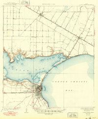 1925 Corpus Christi1949 Print · USGSCorpus Christi and the surrounding coastal plains are captured here in the 1920s, showing the early rail-and-port network of the Texas coast. Researchers can trace rural school locations like Sodville School and early industry at the West Portland Gin.
End of results
Showing maps 1-5 of 5
Top cities near Corpus Christi
- Portland historical maps
- Ingleside historical maps
- Aransas Pass historical maps
- Port Aransas historical maps
- Gregory historical maps
- Ingleside on the Bay historical maps
Top neighborhoods of Corpus Christi
- McNorton historical maps
- San Juan historical maps
- Clarkwood historical maps
- Northwest historical maps
- Mustang-Padre Island historical maps
- South Side historical maps
See more
Frequently asked questions
- What are the different types of historical maps available for Corpus Christi?
- What is the oldest map of Corpus Christi?
- Where can I purchase historical maps of Corpus Christi for my home or office?
- Where can I download high-res historical maps of Corpus Christi?
- Are there historical topographic maps available for Corpus Christi?
- Is there historical aerial imagery available for Corpus Christi?
- Where are historical maps of Corpus Christi sourced from?