1970s Maps of Corpus Christi, Texas
Explore 4 historic maps of Corpus Christi from the 1970s. These maps offer a rare glimpse into what life looked like during the 1970s — showing old roads, neighborhoods, homes, and landmarks that have changed or disappeared over time.
Whether you're researching your family's past, planning a metal detecting trip, or studying how Corpus Christi's landscape evolved across the 1970s, these high-resolution maps are a powerful tool for exploring the history of this region.
- Focus on a specific era: All maps on this page are from the 1970s, giving you a focused view of this time period.
- See what’s changed: Compare century-old streets, trails, and buildings to today's modern landscape using overlays and satellite layers.
- Research with precision: Use these maps for genealogy, historical research, land use analysis, or educational projects.
- View, download, or print: Maps are fully viewable online in high resolution, and can be downloaded or printed for your own records.
Start exploring Corpus Christi's history through authentic maps from the 1970s. This is your window into the past.
Corpus Christi, TX maps
(4)- 1970 Map of Allyns Bight, 1973 Print
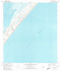 1970 Allyns Bight1973 Print · USGSSan Jose Island and the Aransas coast are captured here in the early seventies, detailing a remote barrier landscape of dunes and tidal lakes. Researchers can locate the Fairmont Ranch, trace the shoreline of Allyns Bight, and identify the Wildlife Obs Station.
 - 1971 Map of Estes, 1973 Print
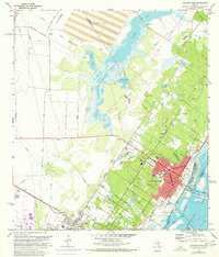
 1971 Estes1973 Print · USGSCoastal Texas in the early seventies reveals a landscape of industrial infrastructure and emerging shorefront communities along the Aransas County line. Trace the rail-and-water economy at the Carbon Black Plant or locate local landmarks like San Antonio Cem and City-by-the-Sea.3 unique versions available
 - 1971 Map of Aransas Pass, 1977 Print
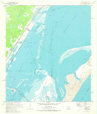
 1971 Aransas Pass1977 Print · USGSThe Texas coastal landscape near Aransas Pass comes alive in the early seventies, showcasing a period of maritime and industrial growth. Researchers can trace family roots through Prairie View Cem or locate old neighborhood schools like Keiberger Sch.
 - 1975 Map of Port Aransas, 1985 Print
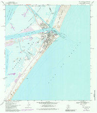 1975 Port Aransas1985 Print · USGSCoastal Texas near the mid-seventies reveals a thriving maritime community and research hub on the barrier islands. Genealogists and researchers can trace local landmarks like Royal Palm Cem, the Aransas Pass Lighthouse, and the Horace Caldwell Pier.
End of results
Showing maps 1-4 of 4
Top cities near Corpus Christi
- Portland historical maps
- Ingleside historical maps
- Aransas Pass historical maps
- Port Aransas historical maps
- Gregory historical maps
- Ingleside on the Bay historical maps
Top neighborhoods of Corpus Christi
- McNorton historical maps
- San Juan historical maps
- Clarkwood historical maps
- Northwest historical maps
- Mustang-Padre Island historical maps
- South Side historical maps
See more
Frequently asked questions
- What are the different types of historical maps available for Corpus Christi?
- What is the oldest map of Corpus Christi?
- Where can I purchase historical maps of Corpus Christi for my home or office?
- Where can I download high-res historical maps of Corpus Christi?
- Are there historical topographic maps available for Corpus Christi?
- Is there historical aerial imagery available for Corpus Christi?
- Where are historical maps of Corpus Christi sourced from?