Old Maps of Corpus Christi, Texas for Metal Detecting
Plan your next treasure hunt with 165 historic maps of Corpus Christi. Find old homesites, ghost towns, trails, and gathering spots that may be lost to time — perfect for identifying promising metal detecting locations.
- Locate forgotten sites: Uncover places like long-lost settlements, abandoned rail lines, or gathering spots.
- Plan better hunts: Use map overlays combined with LiDAR or satellite views to narrow in on historically rich areas.
- Made for detectorists: Thousands of hobbyists use these maps to discover relics, coins, and hidden history.
Use these historic maps to boost your research and find new opportunities beneath the surface of Corpus Christi.
Corpus Christi, TX maps
(165)- 1924 Map of Petronilla
 1924 Petronilla1924 Print · USGSCoastal Texas ranching and cotton farming come to life in the twenties as rail lines connected these plains to wider markets. Trace family lands and rural school sites like Norwood School alongside cattle operations at Ratamosa Ranch and Santa Cruz Ranch.2 unique versions available
 - 1925 Map of Robstown
 1925 Robstown1925 Print · USGSCoastal Texas near the Nueces River delta was a landscape of rail junctions and riverine wetlands during the mid-1920s. Genealogists can locate family landmarks like Ward 1 School or trace the early development of Robstown and Nuecestown.3 unique versions available
 - 1925 Map of Aransas Pass
 1925 Aransas Pass1925 Print · USGSThe Texas Gulf Coast comes to life in the mid-1920s, showing the early railroad developments and barrier island geography of the coastal bend. Trace the original footprints of Aransas Pass, the Aransas Pass Lighthouse, and local landmarks like Mc Campbell School.3 unique versions available
 - 1925 Map of Oso Creek
 1925 Oso Creek1925 Print · USGSThe Texas coastline near Corpus Christi is captured in the mid-1920s, revealing a landscape of coastal ranching and rural schoolhouses. Genealogists and local historians can trace family-named sites like El Camito Ranch, the Morgan Gin, and the Aberdeen Church.2 unique versions available
 - 1925 Map of Corpus Christi, 1949 Print
 1925 Corpus Christi1949 Print · USGSCorpus Christi and the surrounding coastal plains are captured here in the 1920s, showing the early rail-and-port network of the Texas coast. Researchers can trace rural school locations like Sodville School and early industry at the West Portland Gin.
 - 1950 Map of Corpus Christi, 1953 Print
 1950 Corpus Christi1953 Print · USGSThe South Texas coast comes into focus during the early fifties, showing the interplay between booming oil fields and expansive ranching operations. Genealogists and historians can trace the Texas Mexican rail line through Kingsville or locate heritage sites like Chapman Ranch and Riviera Beach.
 - 1951 Map of Portland, 1952 Print
 1951 Portland1952 Print · USGSCoastal Texas in the early fifties is defined here by the maritime and rail activity surrounding Portland. Local historians can trace the original path of the Nueces Bay Causeway, the Southern Pacific line, and the dredging of the Corpus Christi Ship Channel.
 - 1951 Map of Corpus Christi, 1952 Print
 1951 Corpus Christi1952 Print · USGSCorpus Christi at the dawn of the fifties showcases a bustling deep-water port and a rapidly expanding Texas coastal city. Genealogists and local historians can trace family locations through dozens of neighborhood landmarks, including Rose Hill Cem, St Therese Sch, and Cliff Maus Airport.
 - 1951 Map of Corpus Christi, 1952 Print
 1951 Corpus Christi1952 Print · USGSCorpus Christi and its surrounding bays were undergoing significant industrial and maritime growth in the early fifties. Genealogists and local historians can trace family roots at Bellevue Cem or locate former landmarks like Rosita Ranch and the Cliff Maus Airport.2 unique versions available
 - 1951 Map of South Bird Island, 1953 Print
 1951 South Bird Island1953 Print · USGSThe Texas coast near Kleberg County in the early fifties shows a wild landscape of shifting dunes and essential maritime channels. Genealogists and researchers can trace local landmarks like Lobo Windmill (C) and the footprint of Outlying Field 42 (Inactive).
 - 1951 Map of Crane Islands NW, 1953 Print
 1951 Crane Islands NW1953 Print · USGSCoastal Texas near Corpus Christi is captured here in the early fifties, showing the barrier island chain before significant modern development. You can trace the early industrial footprint of the Oil Field and military installations at Corpus Christi Naval Air Station and Demit Island.2 unique versions available
 - 1951 Map of Oso Creek NW, 1953 Print
 1951 Oso Creek NW1953 Print · USGSCoastal Nueces County is seen here during the post-war suburban boom, as the residential streets of Corpus Christi expand south toward Gardendale. Researchers can trace the era's naval aviation footprint at Cabaniss Field and Rodd Field, or locate rural landmarks like Kostoryz Sch and London Sch.
 - 1951 Map of Oso Creek NE, 1953 Print
 1951 Oso Creek NE1953 Print · USGSCoastal Texas near the bay is defined by its strategic military role and growing shoreline communities in the early fifties. Trace the layout of the Corpus Christi Naval Air Station and find family landmarks at Flour Bluff or the University of Corpus Christi.
 - 1951 Map of Crane Islands SW, 1953 Print
 1951 Crane Islands SW1953 Print · USGSThe Texas coast near the Nueces and Kleberg county line is captured here in the early fifties, showing the raw landscape of the barrier islands. Researchers can locate County Park No 1, the local landmark Fourmile Hill, and the project depth of the Intracoastal Waterway.
 - 1951 Map of Allyns Bight, 1953 Print
 1951 Allyns Bight1953 Print · USGSSt Joseph Island and the Aransas County coast are captured in their mid-century natural state, defined by shifting sands and tidal flats. Researchers can trace the isolated Landing Strip and explore the delicate shoreline of Allyns Bight and Allyn Lake.
 - 1951 Map of Oso Creek, 1953 Print
 1951 Oso Creek1953 Print · USGSThe Texas Gulf Coast comes alive in the early fifties as military aviation and ranching shape the outskirts of Corpus Christi. Local researchers can trace the growth of Flour Bluff, locate the historic Chapman Ranch, and identify numerous military sites like Rodd Field.2 unique versions available
 - 1951 Map of Crane Islands, 1957 Print
 1951 Crane Islands1957 Print · USGSThe Texas barrier islands are caught in a moment of post-war coastal development and military expansion. Trace the early layout of the Corpus Christi Naval Air Station and maritime routes through Corpus Christi Pass and Packery Channel.
 - 1951 Map of South Bird Island, 1957 Print
 1951 South Bird Island1957 Print · USGSThe Texas Gulf Coast in the early fifties shows a landscape of expansive cattle ranches and shifting dunes. Genealogists and historians can trace private ranch landmarks like Ojo de Agua, Becerra Wells, and the military footprint at Naval Outlying Field 42 (Practice).2 unique versions available
 - 1954 Map of Aransas Pass, 1956 Print
 1954 Aransas Pass1956 Print · USGSMid-century Aransas Pass and Ingleside are documented here during a period of significant industrial and maritime growth along the Texas coast. Researchers can trace the layout of the Aransas Pass Oil Field, locate Kleberg Sch, and identify old sites like the Tarpon Drive-in Theater.2 unique versions available
 - 1954 Map of Port Ingleside, 1956 Print
 1954 Port Ingleside1956 Print · USGSThe Texas coast near Corpus Christi is captured here in the mid-1950s during a period of significant industrial and maritime expansion. Researchers can trace early energy infrastructure at the Tank Farm and follow the old Southern Pacific line near Ingleside.
 - 1954 Map of Robstown, 1956 Print
 1954 Robstown1956 Print · USGSCoastal Texas in the mid-fifties comes alive through this detailed survey of the rail and petroleum corridor between Robstown and Odem. Genealogists and historians can trace family-named sites like Hudson Acres, old schools like Tuloso-Midway Sch, and the Moravian Community Hall.
 - 1954 Map of Estes, 1956 Print
 1954 Estes1956 Print · USGSThe Aransas coast in the mid-fifties reveals a landscape of barrier islands and early industrial sites like the Carbon Black Plant. Trace historical rail lines through Estes or locate the San Antonio Cem and the Old Terminal.
 - 1954 Map of Port Aransas, 1956 Print
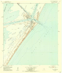 1954 Port Aransas1956 Print · USGSCoastal Texas in the mid-fifties is captured here as a landscape of barrier islands, dredging projects, and maritime industry. Genealogists and historians can trace the early streets of Port Aransas, the location of the Port Aransas Cemetery, and the remote Grant Ranch on Mustang Island.
 - 1954 Map of Petronila, 1956 Print
 1954 Petronila1956 Print · USGSThe South Texas coastal plain during the mid-fifties shows a fascinating transition from ranching to a landscape of oil fields and naval aviation. Researchers can trace historic properties like Laureles Ranch alongside petroleum landmarks like the Luby Oil Field and numerous inactive training sites such as Naval Auxiliary Field 22.
 - 1954 Map of Aransas Pass, 1964 Print
 1954 Aransas Pass1964 Print · USGSThe Texas Gulf Coast comes alive in the mid-fifties, showing the growth of Aransas Pass and Port Aransas alongside vital rail and shipping corridors. Trace old routes like the Toll Road on Mustang Island and locate sites such as Prairie View Cem or the Coast Guard Station.2 unique versions available
Showing maps 1-25 of 165
Top cities near Corpus Christi
- Portland historical maps
- Ingleside historical maps
- Aransas Pass historical maps
- Port Aransas historical maps
- Gregory historical maps
- Ingleside on the Bay historical maps
Top neighborhoods of Corpus Christi
- McNorton historical maps
- San Juan historical maps
- Clarkwood historical maps
- Northwest historical maps
- Mustang-Padre Island historical maps
- South Side historical maps
See more
Frequently asked questions
- What are the different types of historical maps available for Corpus Christi?
- What is the oldest map of Corpus Christi?
- Where can I purchase historical maps of Corpus Christi for my home or office?
- Where can I download high-res historical maps of Corpus Christi?
- Are there historical topographic maps available for Corpus Christi?
- Is there historical aerial imagery available for Corpus Christi?
- Where are historical maps of Corpus Christi sourced from?