1940s Maps of Vidor, Texas
Explore 3 historic maps of Vidor from the 1940s. These maps offer a rare glimpse into what life looked like during the 1940s — showing old roads, neighborhoods, homes, and landmarks that have changed or disappeared over time.
Whether you're researching your family's past, planning a metal detecting trip, or studying how Vidor's landscape evolved across the 1940s, these high-resolution maps are a powerful tool for exploring the history of this region.
- Focus on a specific era: All maps on this page are from the 1940s, giving you a focused view of this time period.
- See what’s changed: Compare century-old streets, trails, and buildings to today's modern landscape using overlays and satellite layers.
- Research with precision: Use these maps for genealogy, historical research, land use analysis, or educational projects.
- View, download, or print: Maps are fully viewable online in high resolution, and can be downloaded or printed for your own records.
Start exploring Vidor's history through authentic maps from the 1940s. This is your window into the past.
Vidor, TX maps
(3)- 1943 Map of Terry, 1953 Print
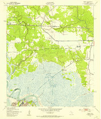 1943 Terry1953 Print · USGSCoastal Texas during the war years reveals a landscape of industrial waterways and remote rail outposts along the Orange and Jefferson County line. Researchers can trace the Southern Pacific line through Terry and locate historic sites like Wallace Cem and Evergreen Ch.
 - 1943 Map of Texla, 1953 Print
 1943 Texla1953 Print · USGSSoutheast Texas at the height of the Second World War shows a landscape defined by the intersection of new rail lines and older timber mill roads. Genealogists can locate family sites like Singleton Cem and Linscomb Cem near the banks of Cow Bayou.
 - 1943 Map of Beaumont East, 1960 Print
 1943 Beaumont East1960 Print · USGSIn the midst of the Second World War, the Texas Gulf Coast's industrial heart thrived along the Neches River and its vital shipping channels. Genealogists and historians can trace the early layout of Lamar College, the famous Spindletop Oil Field, and family plots in Anthony Cem.
End of results
Showing maps 1-3 of 3
Top cities near Vidor
- Beaumont historical maps
- Port Arthur historical maps
- Orange historical maps
- Nederland historical maps
- Groves historical maps
- Port Neches historical maps
See more
Top neighborhoods of Vidor
Frequently asked questions
- What are the different types of historical maps available for Vidor?
- What is the oldest map of Vidor?
- Where can I purchase historical maps of Vidor for my home or office?
- Where can I download high-res historical maps of Vidor?
- Are there historical topographic maps available for Vidor?
- Is there historical aerial imagery available for Vidor?
- Where are historical maps of Vidor sourced from?