1980s Maps of Polk County, Texas
Explore 24 historic maps of Polk County from the 1980s. These maps offer a rare glimpse into what life looked like during the 1980s — showing old roads, neighborhoods, homes, and landmarks that have changed or disappeared over time.
Whether you're researching your family's past, planning a metal detecting trip, or studying how Polk County's landscape evolved across the 1980s, these high-resolution maps are a powerful tool for exploring the history of this region.
- Focus on a specific era: All maps on this page are from the 1980s, giving you a focused view of this time period.
- See what’s changed: Compare century-old streets, trails, and buildings to today's modern landscape using overlays and satellite layers.
- Research with precision: Use these maps for genealogy, historical research, land use analysis, or educational projects.
- View, download, or print: Maps are fully viewable online in high resolution, and can be downloaded or printed for your own records.
Start exploring Polk County's history through authentic maps from the 1980s. This is your window into the past.
Polk County, TX maps
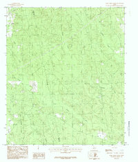
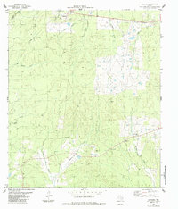
(24)- 1984 Map of Segno
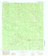
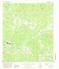
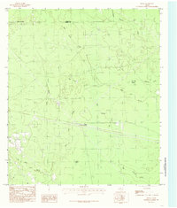
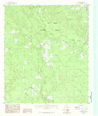 1984 Segno1984 Print · USGSPolk County, Texas, is shown in the mid-1980s as a landscape of dense woods and winding waterways within the Big Thicket National Preserve. Genealogists and local historians can locate rural communities like Holly Grove and Segno, alongside landmarks like the local Lookout Tower.
 - 1984 Map of Hortense
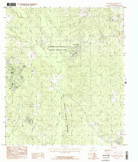
 1984 Hortense1984 Print · USGSThe piney woods of East Texas are captured here in the early 1980s as rural life centered around small hubs and timber tracts. Local researchers can trace old homesteads and forest roads near Hortense, Kennedy, and the winding Bear Creek.
 - 1984 Map of Soda
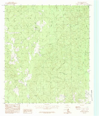
 1984 Soda1984 Print · USGSPolk County during the late seventies and early eighties shows a landscape of timbered creek bottoms and quiet rural crossroads. Genealogists and local historians can locate early burial sites like Nettles Cem and Turner Cem or trace the watercourse of Johnsons Mill Creek.
 - 1984 Map of Beaumont
 1984 Beaumont1984 Print · USGSSoutheast Texas in the late seventies and early eighties shows a landscape of expanding reservoirs and deep timber industry. Researchers can trace the development of the Sam Houston National Forest or locate regional landmarks like Grabbs Prairie and the Wynne State Prison Farm.3 unique versions available
 - 1984 Map of Livingston
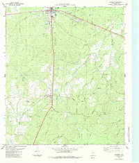
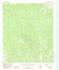
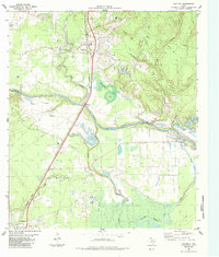
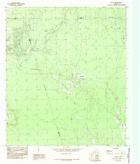
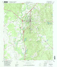 1984 Livingston1984 Print · USGSThe Polk County seat of Livingston flourished in the mid-1980s as a junction for the Southern Pacific railroad and regional pipelines. Trace the legacy of small communities and country churches like Gethsemane Chapel and the wooded grounds of Camp Cho-Yeh.
 - 1984 Map of Jacks Creek South
 1984 Jacks Creek South1984 Print · USGSDeep in the Piney Woods during the early eighties, this area shows the intersection of the energy industry and East Texas timberlands. Genealogists and historians can trace property lines near the Oil Field and along the banks of Big Sandy Creek or Cypress Creek.
 - 1984 Map of Jacks Creek North
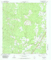
 1984 Jacks Creek North1984 Print · USGSThe Tyler and Polk County borderlands in the mid-eighties reveal a landscape of active resource extraction and utility infrastructure. Genealogists and researchers can trace the paths of Jacks Creek and Big Cypress Creek or locate old Gravel Pits and a Pumping Station.
 - 1984 Map of Dallardsville
 1984 Dallardsville1984 Print · USGSPolk County, Texas, in the mid-1980s reveals a landscape of dense woods and tribal lands at the edge of the Big Thicket. Researchers can trace historical sites like Indian Village and Camp Ruby or locate named water features including Lake Tombigbee and Hung Hook Lake.
 - 1984 Map of Corrigan
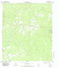
 1984 Corrigan1984 Print · USGSIn the mid-1980s, this pocket of Polk County shows a landscape built on the Southern Pacific railroad and timber interests. Genealogists can locate several family cemeteries like Watts and Jones Cem and rural centers such as Moscow and Bering.
 - 1984 Map of Camden
 1984 Camden1984 Print · USGSIn the mid-1980s, the Piney Woods of East Texas remained a landscape of timber industry and quiet creek-side settlements. Genealogists can trace family footprints near Camden, Chester, and the rural crossroads of Barnum and Barnes.
 - 1984 Map of Chambliss Hill
 1984 Chambliss Hill1984 Print · USGSThe wooded borderlands of Polk and Tyler Counties are shown here as they appeared in the early eighties. Researchers can trace the drainage of Big Creek and locate family-named landmarks like Hubert Spring Branch and Chambliss Hill.
 - 1984 Map of Leggett
 1984 Leggett1984 Print · USGSPolk County wood and oil country is captured here in the mid-eighties as the Southern Pacific rail line serviced the local timber economy. Genealogists can trace family landmarks like Crossroads Cem, Rice Cem, and Providence Ch.
 - 1984 Map of New Willard
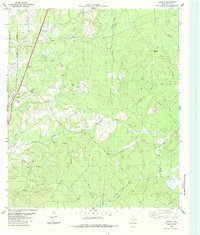
 1984 New Willard1984 Print · USGSPolk County in the late seventies showcases a landscape of timber-town history and rail-side settlements along the Southern Pacific line. Genealogists and researchers can trace family landmarks at Seven Oaks, Bold Springs, and the Alexander Cem.
 - 1984 Map of Palestine
 1984 Palestine1984 Print · USGSEast Texas in the mid-eighties reveals a landscape of massive reservoirs and protected timberlands between Palestine and Nacogdoches. Researchers can trace old routes like the Missouri Pacific RR and locate rural communities such as Tennessee Colony, Latexo, and Etoile.3 unique versions available
 - 1984 Map of Carmona
 1984 Carmona1984 Print · USGSThe Trinity and Polk County line in the mid-1980s reveals a quiet landscape of rural settlements and family heritage sites. Genealogists can trace local history through several burial grounds like Rowe-Dunham Cem and landmarks such as the Carmona Ch.
 - 1984 Map of Goodrich
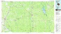
 1984 Goodrich1984 Print · USGSThe Trinity River valley and the Southern Pacific rail corridor are captured here during the mid-1980s. Researchers can locate family landmarks like Lake Pool Cem, rural congregations at Shiloh Ch, and the industrial footprint of the Goodrich Oil Field.
 - 1984 Map of Schwab City
 1984 Schwab City1984 Print · USGSDeep in the Piney Woods during the mid-eighties, this area shows a landscape defined by the Trinity River and the local petroleum industry. Genealogists and historians can trace the community life of Schwab City and Ace through landmarks like Blue Water Cem and Menard Ch.
 - 1984 Map of Romayor, 1985 Print
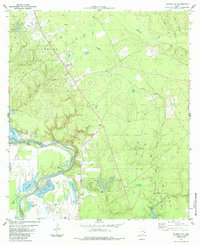
 1984 Romayor1985 Print · USGSThe Trinity River bottomlands of East Texas come alive in the mid-eighties, showing the intersection of Liberty, San Jacinto, and Polk counties. Genealogists and local historians can trace family-named sites like Mc Anally Break or locate the Fields Landing Strip and Horn Crossing.
 - 1984 Map of Bragg, 1985 Print
 1984 Bragg1985 Print · USGSSoutheast Texas in the 1980s reveals a landscape defined by deep woods and wetlands at the junction of Hardin and Polk counties. Researchers can trace local water features and small settlements like Bragg, Jayhawker Baygall, and Little Pine Island Bayou.
 - 1984 Map of Votaw, 1985 Print
 1984 Votaw1985 Print · USGSEast Texas forest and wetlands are captured here in the early eighties as conservation and commerce intersected. Genealogists and historians can trace the rural layouts of Votaw, Fuqua, and Thicket or locate family landmarks near Pine Island Bayou and Wild Cow Marsh.
 - 1985 Map of Livingston
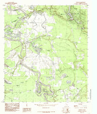
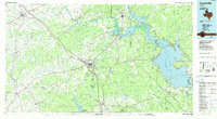
 1985 Livingston1985 Print · USGSEast Texas timber and oil country comes to life in the mid-eighties, showing the deep-set river valleys and forests of Polk and Tyler Counties. Researchers can locate family landmarks like Bold Springs Cem, the Alabama and Coushatta Indian Reservation, and the Livingston Oil Field.
 - 1985 Map of Huntsville
 1985 Huntsville1985 Print · USGSThe East Texas piney woods and the Trinity River basin are captured here in the mid-1980s. Genealogists and historians can trace family locations near Old Waverly, Gospel Hill Ch, and the State Prison Farm during this era of regional growth.2 unique versions available
 - 1986 Map of Beaumont
 1986 Beaumont1986 Print · USGSThe East Texas piney woods and coastal prairies are captured here in the mid-eighties, a period of established energy production and conservation. Researchers can trace the industrial footprint of the Oil and Gas Field near Daisetta and Batson, or locate family sites at Graveyard Hill Cem.
 - 1986 Map of Lufkin
 1986 Lufkin1986 Print · USGSDeep in the Piney Woods during the mid-eighties, this map documents a landscape shaped by vast national forests and the waters of the Sam Rayburn Reservoir. Researchers can trace the legacy of timber and rail through settlements like Diboll, Herty, and Ewing alongside the St Louis Southwestern railroad.
End of results
Showing maps 1-24 of 24
Top cities of Polk County
- Livingston historical maps
- Corrigan historical maps
- Onalaska historical maps
- Goodrich historical maps
- Seven Oaks historical maps
Frequently asked questions
- What are the different types of historical maps available for Polk County?
- What is the oldest map of Polk County?
- Where can I purchase historical maps of Polk County for my home or office?
- Where can I download high-res historical maps of Polk County?
- Are there historical topographic maps available for Polk County?
- Is there historical aerial imagery available for Polk County?
- Where are historical maps of Polk County sourced from?