1930s Maps of Potter County, Texas
Explore 6 historic maps of Potter County from the 1930s. These maps offer a rare glimpse into what life looked like during the 1930s — showing old roads, neighborhoods, homes, and landmarks that have changed or disappeared over time.
Whether you're researching your family's past, planning a metal detecting trip, or studying how Potter County's landscape evolved across the 1930s, these high-resolution maps are a powerful tool for exploring the history of this region.
- Focus on a specific era: All maps on this page are from the 1930s, giving you a focused view of this time period.
- See what’s changed: Compare century-old streets, trails, and buildings to today's modern landscape using overlays and satellite layers.
- Research with precision: Use these maps for genealogy, historical research, land use analysis, or educational projects.
- View, download, or print: Maps are fully viewable online in high resolution, and can be downloaded or printed for your own records.
Start exploring Potter County's history through authentic maps from the 1930s. This is your window into the past.
Potter County, TX maps
(6)- 1934 Map of Ady, 1958 Print
 1934 Ady1958 Print · USGSThe Texas Panhandle ranchlands along the Canadian River were defined by isolated water holes and railroad spurs during the 1930s. Researchers can locate named sites like L S Ranch, Bivins River Camp, and the Old Blackburn Place.2 unique versions available
 - 1934 Map of Cliffside, 1959 Print
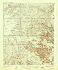
 1934 Cliffside1959 Print · USGSPotter County ranching and rail infrastructure are captured here in the mid-1930s. Genealogists and local historians can trace legacy holdings like Fuqua Ranch and Bivins Ranch alongside rural landmarks like Pleasant Valley Sch.
 - 1936 Map of Fourways
 1936 Fourways1936 Print · USGSThe High Plains of the Texas Panhandle are captured here in the mid-1930s as a landscape of sprawling cattle ranches and emerging industrial sites. Researchers can locate specific family landmarks like Sneeds Ranch and Masterson Ranch or trace the early path of the Panhandle and Santa Fe railroad.2 unique versions available
 - 1936 Map of Cliffside
 1936 Cliffside1936 Print · USGSPotter County ranching and rail infrastructure are captured here in the mid-1930s as the Panhandle modernized. Researchers can trace family-named landmarks like Fuqua Ranch and Bivins Ranch or locate early rural education sites at River Road Sch.2 unique versions available
 - 1936 Map of Ady
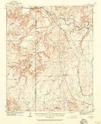
 1936 Ady1936 Print · USGSPotter and Oldham Counties are shown here during the mid-1930s, when the cattle industry and the railroad defined life along the Canadian River. Genealogists and historians can locate early homesteads like Old Blackburn Place and ranching landmarks such as L S Ranch or the Tecovas Spring Fryingpan Ranch.
 - 1939 Map of Sanford
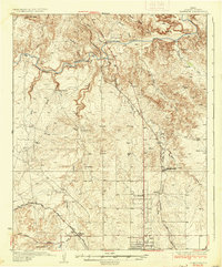
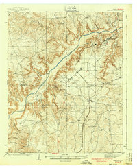 1939 Sanford1939 Print · USGSThe Texas Panhandle comes alive in the late 1930s as ranching and oil industries converge along the Canadian River. Researchers can trace the layout of Fritch and Sanford, or locate family landmarks like Deahl Ranch and Ingerton Ranch.2 unique versions available
End of results
Showing maps 1-6 of 6
Top cities of Potter County
Frequently asked questions
- What are the different types of historical maps available for Potter County?
- What is the oldest map of Potter County?
- Where can I purchase historical maps of Potter County for my home or office?
- Where can I download high-res historical maps of Potter County?
- Are there historical topographic maps available for Potter County?
- Is there historical aerial imagery available for Potter County?
- Where are historical maps of Potter County sourced from?