Old Maps of Potter County, Texas for Academic Research
Study the evolution of Potter County with 161 high-resolution historic maps. Whether you're teaching, researching, or modeling changes in land use, these maps provide essential visual documentation of urban, environmental, and geographic change.
- Analyze long-term change: Track patterns in development, transportation, and natural features.
- Ideal for environmental or urban studies: Support academic projects with primary historical map data.
- Use in the classroom or lab: Educators and researchers rely on these maps to bring historical context to life.
These maps are a powerful tool for teaching, research, and visualizing how Potter County has changed over the decades.
Potter County, TX maps
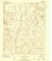
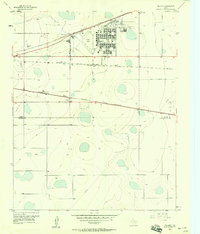
(161)- 1934 Map of Ady, 1958 Print
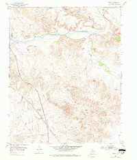
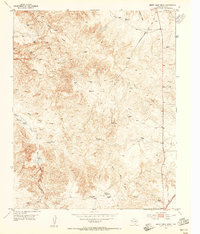
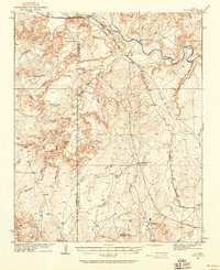 1934 Ady1958 Print · USGSThe Texas Panhandle ranchlands along the Canadian River were defined by isolated water holes and railroad spurs during the 1930s. Researchers can locate named sites like L S Ranch, Bivins River Camp, and the Old Blackburn Place.2 unique versions available
 - 1934 Map of Cliffside, 1959 Print
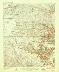
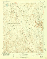
 1934 Cliffside1959 Print · USGSPotter County ranching and rail infrastructure are captured here in the mid-1930s. Genealogists and local historians can trace legacy holdings like Fuqua Ranch and Bivins Ranch alongside rural landmarks like Pleasant Valley Sch.
 - 1936 Map of Fourways
 1936 Fourways1936 Print · USGSThe High Plains of the Texas Panhandle are captured here in the mid-1930s as a landscape of sprawling cattle ranches and emerging industrial sites. Researchers can locate specific family landmarks like Sneeds Ranch and Masterson Ranch or trace the early path of the Panhandle and Santa Fe railroad.2 unique versions available
 - 1936 Map of Cliffside
 1936 Cliffside1936 Print · USGSPotter County ranching and rail infrastructure are captured here in the mid-1930s as the Panhandle modernized. Researchers can trace family-named landmarks like Fuqua Ranch and Bivins Ranch or locate early rural education sites at River Road Sch.2 unique versions available
 - 1936 Map of Ady
 1936 Ady1936 Print · USGSPotter and Oldham Counties are shown here during the mid-1930s, when the cattle industry and the railroad defined life along the Canadian River. Genealogists and historians can locate early homesteads like Old Blackburn Place and ranching landmarks such as L S Ranch or the Tecovas Spring Fryingpan Ranch.
 - 1939 Map of Sanford
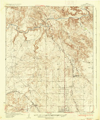
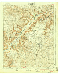 1939 Sanford1939 Print · USGSThe Texas Panhandle comes alive in the late 1930s as ranching and oil industries converge along the Canadian River. Researchers can trace the layout of Fritch and Sanford, or locate family landmarks like Deahl Ranch and Ingerton Ranch.2 unique versions available
 - 1953 Map of Chunky, 1954 Print
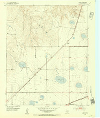
 1953 Chunky1954 Print · USGSPotter County ranching and rail infrastructure are captured here in the early fifties as the Panhandle economy evolved. Genealogists and historians can trace the AT&SF Railroad near Chunky and locate landmarks like Kritser Ranch and Tincup Spring.3 unique versions available
 - 1953 Map of Marsh, 1954 Print
 1953 Marsh1954 Print · USGSThe Texas Panhandle comes alive in the 1950s as a hub of energy and rail transport at the Potter and Moore county line. Trace the industrial footprint of the Panhandle and Santa Fe (At&Sf) Railway and the Fain Compressor Sta amid landmarks like John Ray Butte.2 unique versions available
 - 1953 Map of Puente, 1954 Print
 1953 Puente1954 Print · USGSRanching life in the Texas Panhandle is detailed here in the early fifties as the cattle economy utilized the breaks of the Canadian River. Genealogists and historians can trace family-named outposts like the Fain Ranch, Cross Bar Ranch, and the settlement of Puente.2 unique versions available
 - 1953 Map of Alibates Ranch, 1954 Print
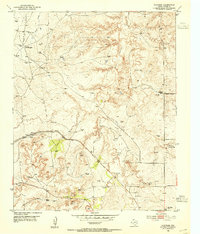
 1953 Alibates Ranch1954 Print · USGSPotter County ranching and the early energy industry come into focus in the early 1950s along the Canadian River. Researchers can trace the layout of the McBride Ranch, Bivins Camp, and the Turkey Creek Plant.
 - 1953 Map of Pleasant Valley, 1954 Print
 1953 Pleasant Valley1954 Print · USGSNorth of Amarillo in the early fifties, the Panhandle landscape was a mix of cattle ranching, caliche mining, and early suburban growth. Genealogists and local historians can locate family landmarks like Bivins Ranch, the Amarillo Speed-Bowl, and the River Road School.3 unique versions available
 - 1953 Map of Deal, 1954 Print
 1953 Deal1954 Print · USGSThe Texas Panhandle in the early fifties was a landscape of expansive cattle spreads and critical rail infrastructure. Trace the Rock Island Line past Poling Ranch and Bennett Ranch, or locate industrial landmarks like the Huber Water Sta.
 - 1953 Map of Mayer, 1954 Print
 1953 Mayer1954 Print · USGSPotter County's High Plains are captured here in the early 1950s, showing a landscape shaped by the Chicago Rock Island and Pacific railroad. Genealogists and local historians can trace the community of St Francis, the Highland Park School, and the local St Francis Cem.3 unique versions available
 - 1953 Map of McDowell Creek, 1954 Print
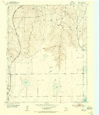
 1953 McDowell Creek1954 Print · USGSThe Texas Panhandle ranching country of the early fifties is defined here by the deep carved canyons of the Canadian River. Genealogists and researchers can locate remote outposts like Scott Headquarters Ranch and a solitary Grave along McDowell Creek.
 - 1953 Map of Cliffside, 1954 Print
 1953 Cliffside1954 Print · USGSPotter County’s gas fields and cattle country are captured here in the mid-twentieth century. Family historians and researchers can trace the Fort Worth and Denver (Burlington) rail line past Cliffside, Townsend Cemetery, and the Cliffside Gas Field Camp.3 unique versions available
 - 1953 Map of Pomeroy, 1954 Print
 1953 Pomeroy1954 Print · USGSThe Texas Panhandle ranching country of the early 1950s is captured here as the era of radio and expanded rail lines reshaped the plains. Researchers can trace the dual rail corridors of the Chicago Rock Island and Pacific and Panhandle and Santa Fe past Masterson and Rockwell Lake.2 unique versions available
 - 1953 Map of Berry Sand Draw, 1955 Print
 1953 Berry Sand Draw1955 Print · USGSDeep in the Texas Panhandle during the early fifties, this map captures the ranching operations and rugged drainages of Potter County. Genealogists can locate Berry Ranch and Wright Ranch, alongside an abandoned Army rifle range and the Rock Island railroad.2 unique versions available
 - 1953 Map of Sevenmile Basin, 1955 Print
 1953 Sevenmile Basin1955 Print · USGSThe Texas Panhandle plains come into focus in the early fifties, showing a landscape defined by natural depressions and the Panhandle and Santa Fe railroad. Trace the settlement at St Francis and find local landmarks like the Tony Ridge Clubhouse.3 unique versions available
 - 1954 Map of Tucumcari, 1965 Print
 1954 Tucumcari1965 Print · USGSThe high plains along the New Mexico and Texas border come alive in this mid-century survey, just as the regional highway network was maturing. Trace the historic route of U.S. 66 through Glenrio and San Jon or locate remote rail sidings like Rehm Station and Obar.2 unique versions available
 - 1954 Map of Amarillo, 1966 Print
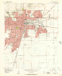
 1954 Amarillo1966 Print · USGSThe Texas Panhandle in the mid-1960s shows a landscape of rising industrial power and deep-rooted ranching tradition. Local historians can trace the paths of the Panhandle and Santa Fe railroad or locate sites like the Pantex Ordnance Plant and Mobeetie.2 unique versions available
 - 1956 Map of Amarillo East, 1957 Print
 1956 Amarillo East1957 Print · USGSAmarillo and the surrounding Panhandle plains are shown here during a period of significant mid-century growth and industrial expansion. Local historians can trace dozens of neighborhood landmarks, from the Tradewind Airport to numerous schools like Carver Sch and Palo Duro High Sch.3 unique versions available
 - 1956 Map of Washburn, 1957 Print
 1956 Washburn1957 Print · USGSThe Texas Panhandle comes alive in the mid-1950s at the vital rail crossing of Washburn, where two major lines met the legendary Route 66. Genealogists and rail historians can trace the local Washburn Cem and the busy junction of the Fort Worth and Denver and the Rock Island railroads.3 unique versions available
 - 1956 Map of Pullman, 1958 Print
 1956 Pullman1958 Print · USGSThe Texas Panhandle comes into focus during the mid-fifties, showing a landscape defined by massive military airbases and a dense crossroads of three major railroads. Trace the development of Amarillo Air Force Base and the small siding at Pullman alongside the Panhandle and Santa Fe tracks.3 unique versions available
 - 1958 Map of Amarillo
 1958 Amarillo1958 Print · USGSThe Texas Panhandle in the mid-1950s reveals a landscape of expanding military installations and oil-rich rail towns. Local historians can trace the development of Amarillo Air Force Base or locate smaller settlements like Magic City and New Mobeetie.
 - 1958 Map of Tucumcari
 1958 Tucumcari1958 Print · USGSEastern New Mexico and the Texas Panhandle meet in this mid-century survey of the high plains ranching and rail corridor. Researchers can trace the path of Mother Road travelers through Tucumcari and Glenrio or locate remote rail stops like Nara Visa Station and Hartley Station.
Showing maps 1-25 of 161
Top cities of Potter County
Frequently asked questions
- What are the different types of historical maps available for Potter County?
- What is the oldest map of Potter County?
- Where can I purchase historical maps of Potter County for my home or office?
- Where can I download high-res historical maps of Potter County?
- Are there historical topographic maps available for Potter County?
- Is there historical aerial imagery available for Potter County?
- Where are historical maps of Potter County sourced from?