1980s Maps of Potter County, Texas
Explore 6 historic maps of Potter County from the 1980s. These maps offer a rare glimpse into what life looked like during the 1980s — showing old roads, neighborhoods, homes, and landmarks that have changed or disappeared over time.
Whether you're researching your family's past, planning a metal detecting trip, or studying how Potter County's landscape evolved across the 1980s, these high-resolution maps are a powerful tool for exploring the history of this region.
- Focus on a specific era: All maps on this page are from the 1980s, giving you a focused view of this time period.
- See what’s changed: Compare century-old streets, trails, and buildings to today's modern landscape using overlays and satellite layers.
- Research with precision: Use these maps for genealogy, historical research, land use analysis, or educational projects.
- View, download, or print: Maps are fully viewable online in high resolution, and can be downloaded or printed for your own records.
Start exploring Potter County's history through authentic maps from the 1980s. This is your window into the past.
Potter County, TX maps
(6)- 1984 Map of Wildorado
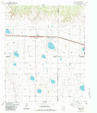 1984 Wildorado1984 Print · USGSWildorado and the surrounding High Plains are captured here during the early eighties, showcasing the intersection of four Texas counties. Researchers can trace land use through the Feedlot and Elevator, or locate landmarks like Highland School and Ida Lake.
 - 1984 Map of Bushland
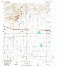 1984 Bushland1984 Print · USGSThe Texas Panhandle plains south of the Canadian River appear here in the early eighties as a hub of agriculture and industry. Researchers can trace the Old Railroad Grade through Bushland or locate the Cement Plant and nearby Quarry.
 - 1985 Map of Hartley, 1986 Print
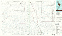 1985 Hartley1986 Print · USGSThe Texas Panhandle in the mid-eighties was a land of sprawling cattle ranches and emerging energy fields linked by deep-rooted rail lines. Genealogists and historians can trace the paths of the Burlington Northern through Channing or locate riverside landmarks like Tascosa and Boys Ranch.2 unique versions available
 - 1985 Map of Vega, 1986 Print
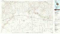 1985 Vega1986 Print · USGSThe Texas Panhandle is captured in the mid-eighties as the cattle and rail economy shaped the landscape from the Canadian River breaks to the southern plains. Researchers can trace the Atchison Topeka and Santa Fe line through Vega and Wildorado or locate landmarks like the Old Railroad Grade and Bivins Lake.2 unique versions available
 - 1986 Map of Borger
 1986 Borger1986 Print · USGSThe Texas Panhandle's energy landscape is captured here in the mid-eighties, showing the intersection of industrial development and the Lake Meredith shoreline. Researchers can trace company-town heritage and rail history through sites like Signal Hill, Supreme Camp, and the Atchison Topeka and Santa Fe railroad line.2 unique versions available
 - 1986 Map of Amarillo
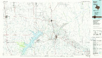
 1986 Amarillo1986 Print · USGSAmarillo and the surrounding Texas Panhandle are captured here in the mid-eighties as a hub of energy, agriculture, and transport. Researchers can trace the sprawling Pantex Plant, the rail-side growth of Panhandle, and the deep cuts of Palo Duro Canyon.2 unique versions available
End of results
Showing maps 1-6 of 6
Top cities of Potter County
Frequently asked questions
- What are the different types of historical maps available for Potter County?
- What is the oldest map of Potter County?
- Where can I purchase historical maps of Potter County for my home or office?
- Where can I download high-res historical maps of Potter County?
- Are there historical topographic maps available for Potter County?
- Is there historical aerial imagery available for Potter County?
- Where are historical maps of Potter County sourced from?