1970s Maps of Real County, Texas
Explore 15 historic maps of Real County from the 1970s. These maps offer a rare glimpse into what life looked like during the 1970s — showing old roads, neighborhoods, homes, and landmarks that have changed or disappeared over time.
Whether you're researching your family's past, planning a metal detecting trip, or studying how Real County's landscape evolved across the 1970s, these high-resolution maps are a powerful tool for exploring the history of this region.
- Focus on a specific era: All maps on this page are from the 1970s, giving you a focused view of this time period.
- See what’s changed: Compare century-old streets, trails, and buildings to today's modern landscape using overlays and satellite layers.
- Research with precision: Use these maps for genealogy, historical research, land use analysis, or educational projects.
- View, download, or print: Maps are fully viewable online in high resolution, and can be downloaded or printed for your own records.
Start exploring Real County's history through authentic maps from the 1970s. This is your window into the past.
Real County, TX maps
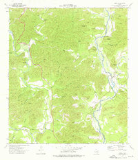
(15)- 1971 Map of Leakey, 1974 Print
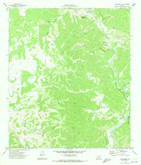
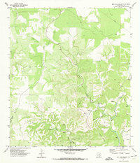
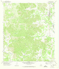 1971 Leakey1974 Print · USGSThe town of Leakey and its surroundings in the early 1970s reveal a community defined by the Frio River and its rugged draws. Genealogists and researchers can locate family landmarks like Exile Cem, Clark Cem, and the springs at Leakey Springs.
 - 1971 Map of Earwood Creek, 1974 Print
 1971 Earwood Creek1974 Print · USGSThe Texas Hill Country at the meeting of Edwards, Real, and Kerr counties was a land of remote ranching and deep draws in the early seventies. Genealogists and historians can locate family-named landmarks like Dardy Windmill and trace the paths of Earwood Creek and Wildcat Draw.
 - 1971 Map of Owl Hollow, 1974 Print
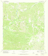
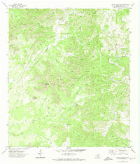
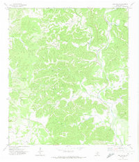 1971 Owl Hollow1974 Print · USGSReal County ranch land is captured in the early seventies as a network of deep hollows and river bends. Trace local topography along the West Frio River, locating remote landmarks like the Landing Strip and named canyons such as Plum Hollow.
 - 1971 Map of Lake Creek, 1974 Print
 1971 Lake Creek1974 Print · USGSThe Uvalde County backcountry in the early 1970s is a landscape of high ridges and spring-fed canyons. Researchers can trace the Old Railroad Grade along the Nueces River or locate rural sites like Blucher and Walnut Springs.
 - 1971 Map of Hackberry, 1974 Print
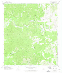
 1971 Hackberry1974 Print · USGSThe Edwards County ranch lands and the Nueces River valley are captured in the early 1970s, showing a landscape of deep draws and isolated homesteads. Researchers can trace family sites at Hackberry Cem, locate the old Laughlin settlement, and identify landmarks like Schoolhouse Mountain.
 - 1971 Map of Joy Hollow, 1974 Print
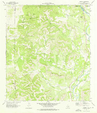
 1971 Joy Hollow1974 Print · USGSDeep in the Texas Hill Country in the early seventies, the Edwards and Real County line runs through a landscape of remote ranch lands and limestone canyons. Researchers can trace family holdings at Eagle Ranch and find unique landmarks like Pape Cave, the Kaolin Mine, and the Blue Hole.
 - 1971 Map of Earwood Creek SW, 1974 Print
 1971 Earwood Creek SW1974 Print · USGSThe Edwards and Real county line in the early seventies shows a landscape shaped by the search for water and mineral resources. Researchers can trace the path of the East Prong Nueces River and locate ranching landmarks like Blair Windmill and Ranger Hollow.2 unique versions available
 - 1971 Map of Reagan Wells, 1974 Print
 1971 Reagan Wells1974 Print · USGSReagan Wells and the rugged Frio River canyons are captured here in the early 1970s. Local researchers can trace family landmarks like Cummins Heard Cemetery, the Heard Community Center, and remote hill country features like Devils Backbone Mountain.
 - 1971 Map of Bee Cave Hollow, 1974 Print
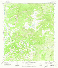
 1971 Bee Cave Hollow1974 Print · USGSThe West Frio River and its intricate canyon systems define this Real County landscape in the early seventies. Genealogists and researchers can trace local landmarks like Prade Ranch, Bee Cave Spring, and the remote Landing Strip.2 unique versions available
 - 1971 Map of Crown Mountain, 1974 Print
 1971 Crown Mountain1974 Print · USGSReal County ranch land is captured in the early 1970s, showcasing a landscape of high plateaus and hidden springs. Researchers can trace remote homesteads and infrastructure like the Landing Strip or find family landmarks like Hatley Hollow and Evans Spring.
 - 1971 Map of Jo Jan Van Camp, 1974 Print
 1971 Jo Jan Van Camp1974 Print · USGSThe canyons and draws of Real County were a network of isolated springs and remote trails in the early seventies. Genealogists and land researchers can trace family-named landmarks like Jo Jan Van Camp or identify watering spots such as Pecan Springs and Pflether Lake.
 - 1973 Map of Montell, 1976 Print
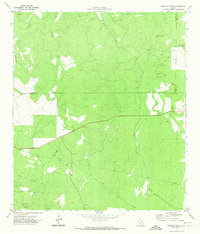
 1973 Montell1976 Print · USGSThe Nueces River valley in the early seventies shows a landscape of remote ranching outposts and vital desert springs. Genealogists and researchers can trace local landmarks like Montell, Shoe Peg Mountain, and the family-named Hayes Mountain.
 - 1973 Map of Vance, 1976 Print
 1973 Vance1976 Print · USGSThe Nueces River valley in the early 1970s reveals a quiet ranching landscape on the border of Edwards and Real counties. Genealogists and historians can locate the Vance settlement, a local Cem, and family-named landmarks like Moffett Mountain.
 - 1973 Map of Camp Wood, 1976 Print
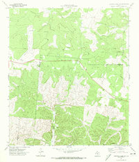
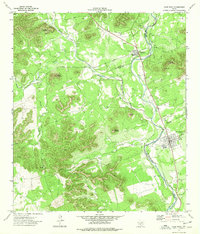 1973 Camp Wood1976 Print · USGSThe Nueces River valley in the early seventies shows the established communities of Barksdale and Camp Wood amidst a rugged landscape of named peaks. Local historians can trace landmarks like the Historical Site, Garden of Memories cemetery, and Old Faithful Spring.
 - 1975 Map of Barksdale
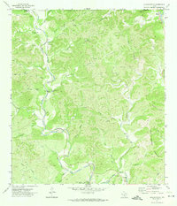
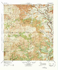 1975 Barksdale1975 Print · USGSThe Nueces River valley in the early 1940s is a landscape of established family ranches and limestone peaks. Genealogists can trace property lines and legacy sites like the Rhodes Ranch, the settlement of Barksdale, and the grounds of Camp Fawcett.
End of results
Showing maps 1-15 of 15
Top cities of Real County
Frequently asked questions
- What are the different types of historical maps available for Real County?
- What is the oldest map of Real County?
- Where can I purchase historical maps of Real County for my home or office?
- Where can I download high-res historical maps of Real County?
- Are there historical topographic maps available for Real County?
- Is there historical aerial imagery available for Real County?
- Where are historical maps of Real County sourced from?