1960s Maps of Real County, Texas
Explore 8 historic maps of Real County from the 1960s. These maps offer a rare glimpse into what life looked like during the 1960s — showing old roads, neighborhoods, homes, and landmarks that have changed or disappeared over time.
Whether you're researching your family's past, planning a metal detecting trip, or studying how Real County's landscape evolved across the 1960s, these high-resolution maps are a powerful tool for exploring the history of this region.
- Focus on a specific era: All maps on this page are from the 1960s, giving you a focused view of this time period.
- See what’s changed: Compare century-old streets, trails, and buildings to today's modern landscape using overlays and satellite layers.
- Research with precision: Use these maps for genealogy, historical research, land use analysis, or educational projects.
- View, download, or print: Maps are fully viewable online in high resolution, and can be downloaded or printed for your own records.
Start exploring Real County's history through authentic maps from the 1960s. This is your window into the past.
Real County, TX maps
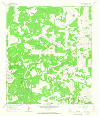
(8)- 1963 Map of Garven Store, 1966 Print
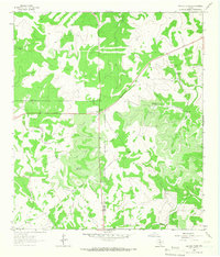 1963 Garven Store1966 Print · USGSThe Texas Hill Country at the edge of the Divide is captured in the early sixties as a ranching landscape defined by the Real and Kerr county line. Researchers can locate remote landmarks like the Divide Community House, Garven Store, and Buffalo Windmill.2 unique versions available
 - 1964 Map of Del Rio
 1964 Del Rio1964 Print · USGSAlong the Mexican border during the mid-sixties, this area centered on the confluence of the Rio Grande and Devils River. Researchers can trace the Southern Pacific line through isolated stops like Pumpville or locate military and industrial sites such as Laughlin Air Force Base and the mines at Blewett.
 - 1964 Map of Hillcrest Ranch, 1966 Print
 1964 Hillcrest Ranch1966 Print · USGSRanching life in the Texas Hill Country during the mid-sixties centered on sprawling family estates and vital water sources. Researchers can trace land boundaries and legacy sites from Hillcrest Ranch to Frio Ranch, as well as local landmarks like Yellow Bluff.
 - 1964 Map of Circle Bluff, 1966 Print
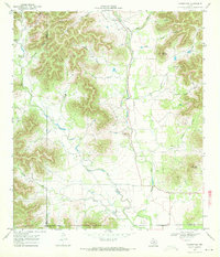
 1964 Circle Bluff1966 Print · USGSReal County ranchlands and the winding canyons of the Frio River are captured here in the mid-1960s. Researchers can locate the Cypress Creek Cem and trace early property lines at Hillcrest Ranch or the Butt Foundation Camp.
 - 1964 Map of Sabinal Canyon, 1967 Print
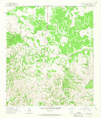
 1964 Sabinal Canyon1967 Print · USGSTexas Hill Country ranching and river drainage are documented in the 1960s along the Real and Bandera county line. Historians can locate family-named landmarks like Wedgeworth, the Post Oak Waterhole, and Flatrock Spring.2 unique versions available
 - 1964 Map of Well Hollow, 1967 Print
 1964 Well Hollow1967 Print · USGSThe headwaters of the Guadalupe and Medina rivers meet at the Kerr and Bandera county line during the mid-sixties. Researchers can trace the rugged drainage of Well Hollow, find a remote Landing Strip, and locate early water infrastructure like the Water Tank.
 - 1969 Map of Vanderpool, 1972 Print
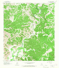
 1969 Vanderpool1972 Print · USGSThe Sabinal River valley in the late sixties reveals a landscape of isolated ranching and deep limestone canyons. Trace local family history and rural industry at the Jones Cem, the Vanderpool settlement, and several named peaks like Taylor Mountain.2 unique versions available
 - 1969 Map of Rio Frio, 1973 Print
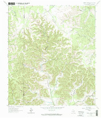
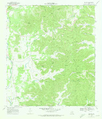 1969 Rio Frio1973 Print · USGSThe Rio Frio area of the Hill Country is documented here in the late sixties, showing the complex river networks of the Edwards Plateau. Genealogists and hikers can locate family-named landmarks like Bailey Hollow and Panther Springs or the local Cem near the river.2 unique versions available
End of results
Showing maps 1-8 of 8
Top cities of Real County
Frequently asked questions
- What are the different types of historical maps available for Real County?
- What is the oldest map of Real County?
- Where can I purchase historical maps of Real County for my home or office?
- Where can I download high-res historical maps of Real County?
- Are there historical topographic maps available for Real County?
- Is there historical aerial imagery available for Real County?
- Where are historical maps of Real County sourced from?