1910s Maps of McLendon-Chisholm, Texas
Explore 2 historic maps of McLendon-Chisholm from the 1910s. These maps offer a rare glimpse into what life looked like during the 1910s — showing old roads, neighborhoods, homes, and landmarks that have changed or disappeared over time.
Whether you're researching your family's past, planning a metal detecting trip, or studying how McLendon-Chisholm's landscape evolved across the 1910s, these high-resolution maps are a powerful tool for exploring the history of this region.
- Focus on a specific era: All maps on this page are from the 1910s, giving you a focused view of this time period.
- See what’s changed: Compare century-old streets, trails, and buildings to today's modern landscape using overlays and satellite layers.
- Research with precision: Use these maps for genealogy, historical research, land use analysis, or educational projects.
- View, download, or print: Maps are fully viewable online in high resolution, and can be downloaded or printed for your own records.
Start exploring McLendon-Chisholm's history through authentic maps from the 1910s. This is your window into the past.
McLendon-Chisholm, TX maps
(2)- 1912 Map of Rockwall
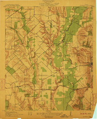 1912 Rockwall1912 Print · USGSTexas blackland prairie and river bottoms are captured here in the years before the landscape was transformed by suburban expansion. Genealogists can locate family homesites near rural landmarks like Lewis Store, Wards Chapel, and the Elm Grove School.2 unique versions available
 - 1919 Map of Royse City
 1919 Royse City1919 Print · USGSThe agricultural heart of Northeast Texas is captured here just after the Great War, as the Blackland Prairie was crisscrossed by essential rail lines. Trace the locations of early rural landmarks like Locust Grove School, the Randle Ranch, and the vanished stop at Rockwall Station.
End of results
Showing maps 1-2 of 2
Top cities near McLendon-Chisholm
- Dallas historical maps
- Plano historical maps
- Garland historical maps
- Mesquite historical maps
- Richardson historical maps
- Allen historical maps
See more
Top neighborhoods of McLendon-Chisholm
Frequently asked questions
- What are the different types of historical maps available for McLendon-Chisholm?
- What is the oldest map of McLendon-Chisholm?
- Where can I purchase historical maps of McLendon-Chisholm for my home or office?
- Where can I download high-res historical maps of McLendon-Chisholm?
- Are there historical topographic maps available for McLendon-Chisholm?
- Is there historical aerial imagery available for McLendon-Chisholm?
- Where are historical maps of McLendon-Chisholm sourced from?