1990s Maps of San Augustine County, Texas
Explore 2 historic maps of San Augustine County from the 1990s. These maps offer a rare glimpse into what life looked like during the 1990s — showing old roads, neighborhoods, homes, and landmarks that have changed or disappeared over time.
Whether you're researching your family's past, planning a metal detecting trip, or studying how San Augustine County's landscape evolved across the 1990s, these high-resolution maps are a powerful tool for exploring the history of this region.
- Focus on a specific era: All maps on this page are from the 1990s, giving you a focused view of this time period.
- See what’s changed: Compare century-old streets, trails, and buildings to today's modern landscape using overlays and satellite layers.
- Research with precision: Use these maps for genealogy, historical research, land use analysis, or educational projects.
- View, download, or print: Maps are fully viewable online in high resolution, and can be downloaded or printed for your own records.
Start exploring San Augustine County's history through authentic maps from the 1990s. This is your window into the past.
San Augustine County, TX maps
(2)- 1992 Map of Nacogdoches
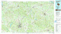 1992 Nacogdoches1992 Print · USGSEast Texas timberlands and river valleys are captured here in the early nineties, centered on the historic regional hub of Nacogdoches. Trace family roots and old rail lines through Cushing, San Augustine, and Logansport along the Southern Pacific RR.
 - 1992 Map of Lufkin
 1992 Lufkin1992 Print · USGSThe Piney Woods of East Texas are captured here in the early nineties, centered on the growing industrial hub of Lufkin. Local researchers can trace the rail networks of the Angelina & Neches River RR and locate rural landmarks like Shady Grove Ch and Manning.
End of results
Showing maps 1-2 of 2
Top cities of San Augustine County
Frequently asked questions
- What are the different types of historical maps available for San Augustine County?
- What is the oldest map of San Augustine County?
- Where can I purchase historical maps of San Augustine County for my home or office?
- Where can I download high-res historical maps of San Augustine County?
- Are there historical topographic maps available for San Augustine County?
- Is there historical aerial imagery available for San Augustine County?
- Where are historical maps of San Augustine County sourced from?