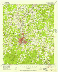
1992 Map of Nacogdoches
USGS Topo · Published 1992About this map
The Sabine National Forest and Angelina National Forest frame a landscape defined by the deep-cut drainages of the Angelina River, Attoyac Bayou, and Sabine River in the early 1990s. This regional study centers on Nacogdoches, showing the city's relationship to the surrounding timberlands and water bodies like Nacogdoches Lake and the vast Toledo Bend Reservoir on the Louisiana border. Smaller communities such as Timpson, Garrison, and Cushing are connected by a network of state highways and the Southern Pacific RR, reflecting the persistent rural settlement patterns of East Texas. The topography is marked by several family-named high points, including Lookout Mountain and Beard Mountain, while the southern reaches of the map transition into the swampy bottomlands of the Sam Rayburn Reservoir. This detailed snapshot of the Piney Woods captures the area's infrastructure before the major expansions of the late 20th century.
Find a feature on this map
164 named features on this map. Tap any name to fly to it.
Don’t see what you’re looking for? This feature index may not catch every label — zoom into the map to look around manually.
Map Details
Editions of this 1992 Nacogdoches Map
This is the sole edition of this map. No revisions or reprints were ever made.
Historical Maps of Nacogdoches Through Time
3 maps found