1960s Maps of San Jacinto County, Texas
Explore 9 historic maps of San Jacinto County from the 1960s. These maps offer a rare glimpse into what life looked like during the 1960s — showing old roads, neighborhoods, homes, and landmarks that have changed or disappeared over time.
Whether you're researching your family's past, planning a metal detecting trip, or studying how San Jacinto County's landscape evolved across the 1960s, these high-resolution maps are a powerful tool for exploring the history of this region.
- Focus on a specific era: All maps on this page are from the 1960s, giving you a focused view of this time period.
- See what’s changed: Compare century-old streets, trails, and buildings to today's modern landscape using overlays and satellite layers.
- Research with precision: Use these maps for genealogy, historical research, land use analysis, or educational projects.
- View, download, or print: Maps are fully viewable online in high resolution, and can be downloaded or printed for your own records.
Start exploring San Jacinto County's history through authentic maps from the 1960s. This is your window into the past.
San Jacinto County, TX maps
(9)- 1960 Map of Blanchard, 1961 Print
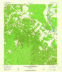
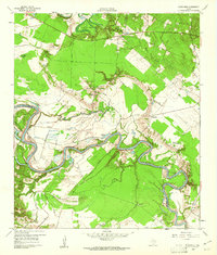 1960 Blanchard1961 Print · USGSEast Texas river life is captured here in the early sixties along the winding Trinity River on the Polk County border. Genealogists and local historians can trace the Old Railroad Grade or locate family sites near Blanchard, Garner Chapel, and Tigerville.3 unique versions available
 - 1960 Map of Maynard, 1962 Print
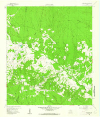 1960 Maynard1962 Print · USGSSan Jacinto County in the early sixties remains a landscape of dense woods and quiet creek bottoms within the Sam Houston National Forest. Genealogists and historians can trace the foundations of Old Waverly and locate local landmarks like the Old Railroad Grade and Hargrove Cem.3 unique versions available
 - 1960 Map of Trinity East, 1962 Print
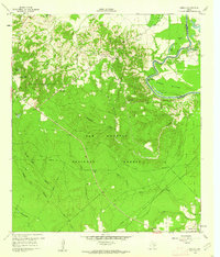
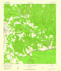 1960 Trinity East1962 Print · USGSThe community of Trinity and its riverfront surroundings are captured in the early 1960s, showing the intersection of rail and river life. Researchers can trace the Missouri Pacific line or follow the Old Railroad Grade past Skaines Lake and the settlement of Sebastopol.3 unique versions available
 - 1960 Map of Carlisle, 1962 Print
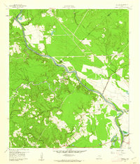 1960 Carlisle1962 Print · USGSThe Trinity River valley at the start of the 1960s reveals a landscape of small churches, family cemeteries, and old transit corridors. Genealogists and local historians can locate the Patricks Ferry site, the Pointblank School, and family landmarks like Darby Hill.3 unique versions available
 - 1960 Map of Stephen Creek, 1962 Print
 1960 Stephen Creek1962 Print · USGSThe East Texas piney woods and Trinity River bottomlands are captured here at the start of the 1960s. Researchers can locate family landmarks like the Paul Horton Memorial Ch, Liberty Hill Cem, and the Willow Springs Lookout.3 unique versions available
 - 1960 Map of Camilla, 1962 Print
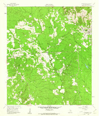
 1960 Camilla1962 Print · USGSSan Jacinto County in the early sixties remains a landscape of dense timber and river bottomlands within the Sam Houston National Forest. Genealogists and local historians can trace family locations at Sweet Home, search for ancestors at Gorman Cem, or locate the Old RR Grade in the woods.4 unique versions available
 - 1960 Map of Coldspring, 1962 Print
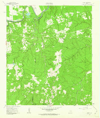
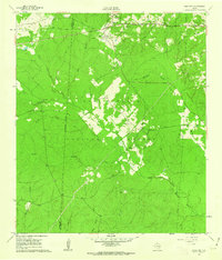
 1960 Coldspring1962 Print · USGSColdspring and the surrounding timberlands of San Jacinto County are captured here in the early sixties. Genealogists can trace family roots through numerous remote burial sites like Evergreen Cem and Youngblood Cem, or locate the Coline Oil Field and the Old Railroad Grade.3 unique versions available
 - 1961 Map of Staley, 1962 Print
 1961 Staley1962 Print · USGSDeep in the Piney Woods of the early sixties, this survey shows the rugged creek drainages and forest boundaries along the San Jacinto and Walker county lines. Trace family history through local landmarks like Gospel Hill Sch, Staley (Embryfield), and Community Relief Cem.2 unique versions available
 - 1961 Map of Oakhurst, 1962 Print
 1961 Oakhurst1962 Print · USGSSan Jacinto and Walker Counties appear here in the early sixties, centered on the interface of the deep woods and rural homesteads. Genealogists can trace family landmarks like White Hill Missionary Ch, the Hoby Cem, and the Old Railroad Grade.3 unique versions available
End of results
Showing maps 1-9 of 9
Top cities of San Jacinto County
Frequently asked questions
- What are the different types of historical maps available for San Jacinto County?
- What is the oldest map of San Jacinto County?
- Where can I purchase historical maps of San Jacinto County for my home or office?
- Where can I download high-res historical maps of San Jacinto County?
- Are there historical topographic maps available for San Jacinto County?
- Is there historical aerial imagery available for San Jacinto County?
- Where are historical maps of San Jacinto County sourced from?