1960s Maps of Edroy, Texas
Explore 3 historic maps of Edroy from the 1960s. These maps offer a rare glimpse into what life looked like during the 1960s — showing old roads, neighborhoods, homes, and landmarks that have changed or disappeared over time.
Whether you're researching your family's past, planning a metal detecting trip, or studying how Edroy's landscape evolved across the 1960s, these high-resolution maps are a powerful tool for exploring the history of this region.
- Focus on a specific era: All maps on this page are from the 1960s, giving you a focused view of this time period.
- See what’s changed: Compare century-old streets, trails, and buildings to today's modern landscape using overlays and satellite layers.
- Research with precision: Use these maps for genealogy, historical research, land use analysis, or educational projects.
- View, download, or print: Maps are fully viewable online in high resolution, and can be downloaded or printed for your own records.
Start exploring Edroy's history through authentic maps from the 1960s. This is your window into the past.
Edroy, TX maps
(3)- 1960 Map of Corpus Christi
 1960 Corpus Christi1960 Print · USGSCoastal South Texas and the Nueces County hinterlands are detailed in this mid-century survey. Genealogists and historians can trace early settlement patterns and rural landmarks like Casa Blanca during a period of steady regional growth.
 - 1966 Map of Corpus Christi
 1966 Corpus Christi1966 Print · USGSThe Texas Coastal Bend in the mid-1960s reveals a landscape where massive cattle empires and strategic military bases meet the Gulf. Trace the vast reaches of King Ranch or locate aviation history at the Corpus Christi Air Station and Kingsville Air Station.
 - 1969 Map of Edroy, 1972 Print
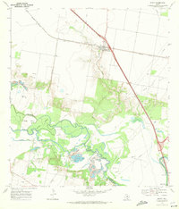 1969 Edroy1972 Print · USGSIn the late 1960s, this San Patricio County landscape was defined by the winding Nueces River and a busy energy economy. Researchers can trace family sites in Edroy, locate the Guadalupe Ch, and map the extensive Riverside Oil Field.2 unique versions available
End of results
Showing maps 1-3 of 3
Top cities near Edroy
- Corpus Christi historical maps
- Robstown historical maps
- Sinton historical maps
- Mathis historical maps
- Odem historical maps
- Lake City historical maps
Frequently asked questions
- What are the different types of historical maps available for Edroy?
- What is the oldest map of Edroy?
- Where can I purchase historical maps of Edroy for my home or office?
- Where can I download high-res historical maps of Edroy?
- Are there historical topographic maps available for Edroy?
- Is there historical aerial imagery available for Edroy?
- Where are historical maps of Edroy sourced from?