1990s Maps of Sherman County, Texas
Explore 2 historic maps of Sherman County from the 1990s. These maps offer a rare glimpse into what life looked like during the 1990s — showing old roads, neighborhoods, homes, and landmarks that have changed or disappeared over time.
Whether you're researching your family's past, planning a metal detecting trip, or studying how Sherman County's landscape evolved across the 1990s, these high-resolution maps are a powerful tool for exploring the history of this region.
- Focus on a specific era: All maps on this page are from the 1990s, giving you a focused view of this time period.
- See what’s changed: Compare century-old streets, trails, and buildings to today's modern landscape using overlays and satellite layers.
- Research with precision: Use these maps for genealogy, historical research, land use analysis, or educational projects.
- View, download, or print: Maps are fully viewable online in high resolution, and can be downloaded or printed for your own records.
Start exploring Sherman County's history through authentic maps from the 1990s. This is your window into the past.
Sherman County, TX maps
(2)- 1998 Map of Brickel, 2001 Print
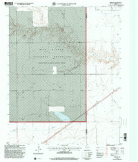 1998 Brickel2001 Print · USGSThe high plains of the Texas Panhandle appear here in the late nineties, where the Rita Blanca National Grassland meets the Sherman County line. Researchers can trace the layout of sparse settlements like Brickel and Flores alongside ranching infrastructure and a labeled Quarry.
 - 1998 Map of Kerrick, 2001 Print
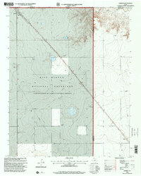 1998 Kerrick2001 Print · USGSThe Texas Panhandle meets the Oklahoma border in the late nineties, where the Rita Blanca National Grassland preserves the open range. Trace the rail-side infrastructure of Kerrick or locate an Oil Well and Pipeline across this energy-rich landscape.
End of results
Showing maps 1-2 of 2
Top cities of Sherman County
Frequently asked questions
- What are the different types of historical maps available for Sherman County?
- What is the oldest map of Sherman County?
- Where can I purchase historical maps of Sherman County for my home or office?
- Where can I download high-res historical maps of Sherman County?
- Are there historical topographic maps available for Sherman County?
- Is there historical aerial imagery available for Sherman County?
- Where are historical maps of Sherman County sourced from?