1940s Maps of Webb County, Texas
Explore 4 historic maps of Webb County from the 1940s. These maps offer a rare glimpse into what life looked like during the 1940s — showing old roads, neighborhoods, homes, and landmarks that have changed or disappeared over time.
Whether you're researching your family's past, planning a metal detecting trip, or studying how Webb County's landscape evolved across the 1940s, these high-resolution maps are a powerful tool for exploring the history of this region.
- Focus on a specific era: All maps on this page are from the 1940s, giving you a focused view of this time period.
- See what’s changed: Compare century-old streets, trails, and buildings to today's modern landscape using overlays and satellite layers.
- Research with precision: Use these maps for genealogy, historical research, land use analysis, or educational projects.
- View, download, or print: Maps are fully viewable online in high resolution, and can be downloaded or printed for your own records.
Start exploring Webb County's history through authentic maps from the 1940s. This is your window into the past.
Webb County, TX maps
(4)- 1940 Map of Aguilares
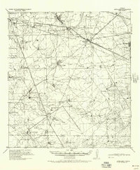 1940 Aguilares1940 Print · USGSSouth Texas ranching and the early oil industry meet in the late 1930s along the Texas Mexican Railroad. Local historians can trace family landholdings from Zapata Ranch to Dodier Ranch, or locate commerce hubs like Pullin Store and the Magnolia Pump Station.
 - 1940 Map of Velenzuela Creek, 1958 Print
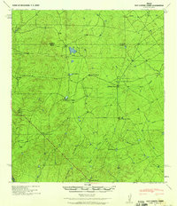
 1940 Velenzuela Creek1958 Print · USGSSouth Texas ranching country at the start of the 1940s shows a landscape of expansive family holdings and seasonal creek beds. Researchers can locate specific sites like Velenzuela Ranch, the Hill Top Inn, and S Cotulla.2 unique versions available
 - 1940 Map of San Loranzo Creek, 1958 Print
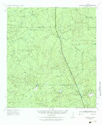
 1940 San Loranzo Creek1958 Print · USGSThe ranching country of the Webb and Dimmit borderlands is captured here just before the mid-century, defined by scattered holdings and vital water tanks. Researchers can trace historic property boundaries and find locations like Brown Ranch, the Ruins site, and the Dos Hermanos Peaks.3 unique versions available
 - 1940 Map of Chupadera, 1959 Print
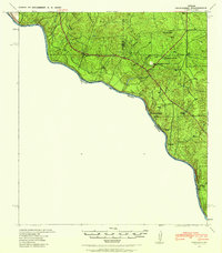 1940 Chupadera1959 Print · USGSThe Texas-Mexico borderlands along the Rio Grande are captured here just before the war, showing the remote ranching country of Webb Co. Researchers can locate isolated water sources and early landmarks like Chupadera Ranch, Sullivan Spring, and Cathedral Rock.2 unique versions available
End of results
Showing maps 1-4 of 4
Top cities of Webb County
- Laredo historical maps
- Rio Bravo historical maps
- El Cenizo historical maps
- Oilton historical maps
- Bruni historical maps
- La Presa historical maps
See more
Frequently asked questions
- What are the different types of historical maps available for Webb County?
- What is the oldest map of Webb County?
- Where can I purchase historical maps of Webb County for my home or office?
- Where can I download high-res historical maps of Webb County?
- Are there historical topographic maps available for Webb County?
- Is there historical aerial imagery available for Webb County?
- Where are historical maps of Webb County sourced from?