1970s Maps of Webb County, Texas
Explore 14 historic maps of Webb County from the 1970s. These maps offer a rare glimpse into what life looked like during the 1970s — showing old roads, neighborhoods, homes, and landmarks that have changed or disappeared over time.
Whether you're researching your family's past, planning a metal detecting trip, or studying how Webb County's landscape evolved across the 1970s, these high-resolution maps are a powerful tool for exploring the history of this region.
- Focus on a specific era: All maps on this page are from the 1970s, giving you a focused view of this time period.
- See what’s changed: Compare century-old streets, trails, and buildings to today's modern landscape using overlays and satellite layers.
- Research with precision: Use these maps for genealogy, historical research, land use analysis, or educational projects.
- View, download, or print: Maps are fully viewable online in high resolution, and can be downloaded or printed for your own records.
Start exploring Webb County's history through authentic maps from the 1970s. This is your window into the past.
Webb County, TX maps
(14)- 1972 Map of Albercas Ranch, 1975 Print
 1972 Albercas Ranch1975 Print · USGSThe ranching and energy country of south Texas is captured here in the early seventies as petroleum production transformed the brushland. Genealogists and historians can locate family landmarks like San Jose Ranch, Graves, and the drainage of Arroyo Grande.
 - 1972 Map of Bruni SE, 1975 Print
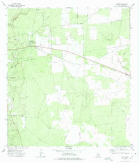
 1972 Bruni SE1975 Print · USGSIn the early 1970s, this corner of South Texas was a hub for energy extraction where Webb, Duval, and Jim Hogg counties meet. Genealogists and historians can trace the Texas Mexican railroad line, locate the Greenhill Cem, and map the extent of the Yeager Oil Field.
 - 1972 Map of Bruni, 1975 Print
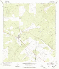 1972 Bruni1975 Print · USGSWebb and Duval County ranchlands are captured here in the 1970s during a period of intense oil exploration. You can trace the Texas Mexican rail line through Bruni, find numerous oil derricks in the Cole Oil Field, and locate named landmarks like El Medio Windmill.
 - 1972 Map of Oilton, 1975 Print
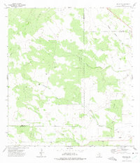
 1972 Oilton1975 Print · USGSSouth Texas petroleum country comes into focus in the early seventies as the regional oil boom shapes the land. Trace the industrial footprint of the Mirando City Oil Field and find historic sites like Los Ojuelos and the Texas Mexican line.
 - 1973 Map of Biel Lake North, 1977 Print
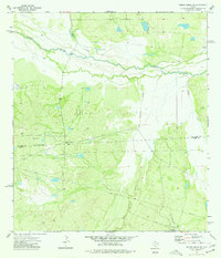
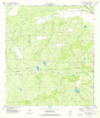
 1973 Biel Lake North1977 Print · USGSWebb County ranchlands and energy resources are captured in the early seventies, featuring the extensive Biel Oil Field. Researchers can locate working landscapes like the Las Pintas Ranch and trace water sources from San Casimiro Creek to Biel Lake.
 - 1974 Map of Piedra Creek SW, 1977 Print
 1974 Piedra Creek SW1977 Print · USGSThe South Texas brush country along the Nueces River comes into focus during the mid-seventies. Researchers can trace the ranching legacy of the Welder Dobie Ranch or locate early industrial markers like the Flowing Well and Gravel Pits.
 - 1974 Map of Caiman Creek SE, 1977 Print
 1974 Caiman Creek SE1977 Print · USGSThe brush country along the La Salle and Webb border in the mid-1970s reveals a landscape of ranching and oil exploration. Researchers can trace the path of the Nueces River and locate remote landmarks like the Landing Strip and Monte Cortado.
 - 1974 Map of Piedra Creek SE, 1977 Print
 1974 Piedra Creek SE1977 Print · USGSThe South Texas brush country at the meeting of four counties is captured here in the mid-1970s. Researchers can trace family landmarks like the Adami Cem or map the energy footprint of the Rodriguez Oil Field and scattered Gas Wells.
 - 1974 Map of Biel Lake SE, 1977 Print
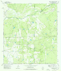
 1974 Biel Lake SE1977 Print · USGSPetroleum production and ranch land define the border of Webb and Duval counties during the mid-seventies. Researchers can trace energy infrastructure across the Lopez Oil Field, find scattered Oil Wells, and locate the Arroyo de Charco Escondido.
 - 1974 Map of Biel Lake South, 1977 Print
 1974 Biel Lake South1977 Print · USGSSouth Texas ranching and energy production meet in this mid-seventies survey of Webb County. Genealogists and historians can trace family-named sites like Las Mujeres Ranch and Torres or the industrial footprint of the Talvez Oil Field.
 - 1974 Map of Biel Lake NE, 1977 Print
 1974 Biel Lake NE1977 Print · USGSThe Webb and Duval county line in the mid-seventies was a center of intensive energy production. Researchers can trace the infrastructure of the Charamusca Oil Field, from the central refinery to scattered oil wells and pipelines.
 - 1979 Map of Isla Mesteno
 1979 Isla Mesteno1979 Print · USGSThe Texas-Mexico borderlands come into focus in the late 1970s as the Rio Grande winds past remote ranching settlements and gas fields. Researchers can trace family-named sites like Las Josefinas, the abandoned San Pablo, and the Aduana at La Rivereña.
 - 1979 Map of Laredo South, 1980 Print
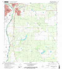 1979 Laredo South1980 Print · USGSThe international border at the end of the 1970s shows the twin cities of Laredo and Nuevo Laredo flanking the Rio Bravo Grande. Researchers can trace rural settlements like Santa Maria (Angelica) and community landmarks like Masterson Sch.2 unique versions available
 - 1979 Map of O'Keefe Lake, 1981 Print
 1979 O'Keefe Lake1981 Print · USGSThe Texas-Mexico borderlands along the Webb and Zapata county lines come into focus in this late-seventies survey. Genealogists and historians can trace small ranching outposts such as Las Josefinas and El Porvenir near the banks of the Falcon Reservoir.
End of results
Showing maps 1-14 of 14
Top cities of Webb County
- Laredo historical maps
- Rio Bravo historical maps
- El Cenizo historical maps
- Oilton historical maps
- Bruni historical maps
- La Presa historical maps
See more
Frequently asked questions
- What are the different types of historical maps available for Webb County?
- What is the oldest map of Webb County?
- Where can I purchase historical maps of Webb County for my home or office?
- Where can I download high-res historical maps of Webb County?
- Are there historical topographic maps available for Webb County?
- Is there historical aerial imagery available for Webb County?
- Where are historical maps of Webb County sourced from?