1950s Maps of Webb County, Texas
Explore 13 historic maps of Webb County from the 1950s. These maps offer a rare glimpse into what life looked like during the 1950s — showing old roads, neighborhoods, homes, and landmarks that have changed or disappeared over time.
Whether you're researching your family's past, planning a metal detecting trip, or studying how Webb County's landscape evolved across the 1950s, these high-resolution maps are a powerful tool for exploring the history of this region.
- Focus on a specific era: All maps on this page are from the 1950s, giving you a focused view of this time period.
- See what’s changed: Compare century-old streets, trails, and buildings to today's modern landscape using overlays and satellite layers.
- Research with precision: Use these maps for genealogy, historical research, land use analysis, or educational projects.
- View, download, or print: Maps are fully viewable online in high resolution, and can be downloaded or printed for your own records.
Start exploring Webb County's history through authentic maps from the 1950s. This is your window into the past.
Webb County, TX maps
(13)- 1953 Map of Crystal City
 1953 Crystal City1953 Print · USGSSouth Texas in the early fifties was a landscape of expanding oil fields and vital rail connections. Genealogists and researchers can trace family lands along the Nueces River or locate heritage sites in Asherton, Big Wells, and Batesville.
 - 1955 Map of Crystal City, 1976 Print
 1955 Crystal City1976 Print · USGSSouth Texas ranching and oil country come into focus in the mid-fifties as the rail lines and rivers connect growing hubs. Researchers can trace the development of energy fields like Washburn Oil Field or locate historic settlements from Asherton to Three Rivers.
 - 1956 Map of Las Tiendas
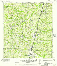
 1956 Las Tiendas1956 Print · USGSThe South Texas ranching country of Webb County is meticulously mapped during the late twenties and thirties, showing a vast network of family cattle spreads. Genealogists and historians can trace the boundaries of the Las Tiendas Ranch, Casa Blanca Ranch, and Centeno Ranch across this semi-arid landscape.
 - 1956 Map of Becerra
 1956 Becerra1956 Print · USGSCattle ranching and rural life in Webb County are preserved here as they were in the years before World War II. Genealogists and local historians can trace family landholdings like Becerra Ranch and Gato Ranch or locate the site of the Buena Vista School.
 - 1956 Map of Piedra Creek
 1956 Piedra Creek1956 Print · USGSThe ranching country of La Salle and McMullen Counties is captured here in the mid-1950s, following military surveys of the brushy plains. Researchers can locate remote family landmarks like the Dobie Ranch or trace the early Oil Field at Munson.
 - 1956 Map of Islitas
 1956 Islitas1956 Print · USGSThe riverfront north of Laredo was a hub of early twentieth-century industry and ranching along the Rio Grande. Genealogists and historians can trace family-named holdings like Tordillo Settlement and the industrial infrastructure of the Rio Grande and Eagle Pass Railroad.
 - 1956 Map of Laredo East
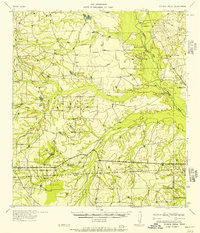
 1956 Laredo East1956 Print · USGSEastern Webb County is documented here as a vast network of cattle ranches and rail sidings during the mid-twentieth century. Family researchers can locate legacy holdings like the Pool Ranch and L.R. Ortiz Ranch, or trace the Texas Mexican Railway past Milo Siding.
 - 1956 Map of Webb
 1956 Webb1956 Print · USGSSouth Texas ranching country was dominated by large family estates and vital rail links in the mid-1950s. Trace the footprints of historic properties like Nuevo Ranch and J B de Carnera along the International Great Northern Railroad.
 - 1956 Map of Las Mujeres
 1956 Las Mujeres1956 Print · USGSRanching life on the Webb and Duval county border is captured here during the mid-twentieth century as new infrastructure began to arrive. Genealogists and historians can trace family land holdings such as Jotana Ranch, Puertacita Ranch, and the homestead of Don Adami.
 - 1956 Map of Laredo, 1960 Print
 1956 Laredo1960 Print · USGSSouth Texas in the mid-fifties reveals a landscape shaped by border commerce, military aviation, and a booming oil industry. Trace the historic Texas and Mexican RR line through Hebbronville or locate the sprawling Mirando City Oil Field and Laredo AFB.3 unique versions available
 - 1957 Map of Encinal
 1957 Encinal1957 Print · USGSThe South Texas brush country around the Webb and La Salle county lines is captured here during a period of established ranching and rail commerce. Family historians can trace numerous homesteads and landmarks like Prairie View School, Bell Ranch, and Atlee Siding.
 - 1957 Map of Caiman Creek
 1957 Caiman Creek1957 Print · USGSThe South Texas brush country along the Nueces River appears here during the mid-1950s ranching era. Genealogists and local historians can locate specific family-held lands like Jefferies Ranch and landmarks such as the Ft Ewell Monument.2 unique versions available
 - 1958 Map of Eagle Pass, 1969 Print
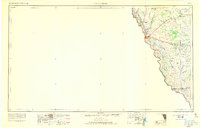 1958 Eagle Pass1969 Print · USGSThe borderlands of South Texas come alive in this mid-century look at the ranching and rail corridor along the Rio Grande. Genealogists and historians can trace legacy holdings like San Pedro Ranch, find the Maverick Canal network, and locate rail sidings at Darling.2 unique versions available
End of results
Showing maps 1-13 of 13
Top cities of Webb County
- Laredo historical maps
- Rio Bravo historical maps
- El Cenizo historical maps
- Oilton historical maps
- Bruni historical maps
- La Presa historical maps
See more
Frequently asked questions
- What are the different types of historical maps available for Webb County?
- What is the oldest map of Webb County?
- Where can I purchase historical maps of Webb County for my home or office?
- Where can I download high-res historical maps of Webb County?
- Are there historical topographic maps available for Webb County?
- Is there historical aerial imagery available for Webb County?
- Where are historical maps of Webb County sourced from?