1980s Maps of Webb County, Texas
Explore 45 historic maps of Webb County from the 1980s. These maps offer a rare glimpse into what life looked like during the 1980s — showing old roads, neighborhoods, homes, and landmarks that have changed or disappeared over time.
Whether you're researching your family's past, planning a metal detecting trip, or studying how Webb County's landscape evolved across the 1980s, these high-resolution maps are a powerful tool for exploring the history of this region.
- Focus on a specific era: All maps on this page are from the 1980s, giving you a focused view of this time period.
- See what’s changed: Compare century-old streets, trails, and buildings to today's modern landscape using overlays and satellite layers.
- Research with precision: Use these maps for genealogy, historical research, land use analysis, or educational projects.
- View, download, or print: Maps are fully viewable online in high resolution, and can be downloaded or printed for your own records.
Start exploring Webb County's history through authentic maps from the 1980s. This is your window into the past.
Webb County, TX maps
(45)- 1980 Map of Blancas Creek North
 1980 Blancas Creek North1980 Print · USGSWebb County ranch land in the 1970s is documented here as a landscape of brush and resource extraction. Researchers can trace the paths of Dolores Creek and Blancas Creek or locate ranching infrastructure like the isolated well.
 - 1980 Map of Alamito Creek
 1980 Alamito Creek1980 Print · USGSWebb County ranch lands and water management are captured here in the late seventies. Family historians and researchers can locate the Becerra Cem or trace the drainage paths of Salado Creek and Alamito Creek across the territory.
 - 1980 Map of Agua Azul Creek East
 1980 Agua Azul Creek East1980 Print · USGSThe brushlands of South Texas appear at the height of their energy development in the early eighties. Genealogists and researchers can trace family-named landmarks and infrastructure like Agua Azul Creek, the Oil Field, and the Webb Co Zapata Co line.
 - 1980 Map of Mirando City
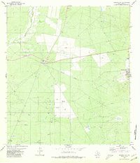 1980 Mirando City1980 Print · USGSMirando City and Aguilares appear during the South Texas oil and gas era of the early eighties. Genealogists and researchers can trace the Texas Mexican railway, locate the San Pedro Cem, and identify numerous Oil Wells and pipelines.
 - 1980 Map of Callaghan Ranch SE
 1980 Callaghan Ranch SE1980 Print · USGSSouth Texas ranch land is captured in the early 1980s, documenting the vital water and energy infrastructure of Webb County. Researchers can trace the layout of The Old Ranch, numerous livestock Tanks, and a major regional Pipeline.
 - 1980 Map of Venado Creek West
 1980 Venado Creek West1980 Print · USGSRanching life in Webb County during the late seventies is centered on the vital watercourses and rail lines of the brush country. Researchers can trace family-named landmarks like Bruni Ranch, the settlement at San Roman, and the corridor of the Missouri Pacific railroad.
 - 1980 Map of Burrito Tank
 1980 Burrito Tank1980 Print · USGSSouth Texas ranching country in the early eighties is defined by the rail corridor and essential water infrastructure. Researchers can trace the Texas Mexican line near Killam and locate family landmarks like Yugo Ranch and the Grave.
 - 1980 Map of Agua Azul Creek West
 1980 Agua Azul Creek West1980 Print · USGSWebb and Zapata counties appear here during the early eighties, showcasing a landscape of South Texas ranching and energy production. Researchers can trace land use through features like the Landing Strip, Oil Wells, and water sources like Los Lasos Tank.
 - 1980 Map of Blancas Creek South
 1980 Blancas Creek South1980 Print · USGSThe South Texas brush country along the Webb and Zapata county line is captured in the late seventies just as energy exploration was intensifying. Researchers can trace land divisions and drainage systems like Dolores Creek, George hill, and scattered Gas Wells.
 - 1980 Map of Piedra Parada Ranch
 1980 Piedra Parada Ranch1980 Print · USGSRanching life in Webb County during the late seventies is centered around isolated homesteads and vital water catchments. Genealogists and historians can trace the boundaries of the Piedra Parada Ranch and locate landmarks like Hilltop Ranch and Home Tank.
 - 1980 Map of Piedra Parada Tank
 1980 Piedra Parada Tank1980 Print · USGSWebb County ranch land in the early eighties is defined here by its vital water catchments and seasonal drainages. Researchers can trace the network of Piedra Parada Tank and Burro Tank alongside industrial markers like the central Gas Well.
 - 1980 Map of Shipp Ranch
 1980 Shipp Ranch1980 Print · USGSWebb County ranching country is documented here in the early eighties, showing a landscape defined by water management and vast open range. Researchers can trace land use through scores of named water features like Certificado Tank, Blackie Tank, and Shipp Ranch.
 - 1980 Map of Callaghan Ranch South
 1980 Callaghan Ranch South1980 Print · USGSWebb County ranching country is captured here during the 1980s, centered on the cattle and rail hub of the Callaghan Ranch. Trace the lineage of the landscape through the Castro Cem and old sidings at Botines and Webb.
 - 1980 Map of Callaghan Ranch North
 1980 Callaghan Ranch North1980 Print · USGSWebb County ranching and rail infrastructure are captured here in the early eighties. Researchers can trace family-named sites like Cerrito Prieto Ranch and follow the Missouri Pacific line through San Roman and Cactus.
 - 1980 Map of Venado Creek East
 1980 Venado Creek East1980 Print · USGSWebb County ranch lands are captured here in the early eighties, showing a landscape defined by seasonal water and energy infrastructure. Researchers can trace the drainage of Venado Creek and locate landmarks like Becerra and several unnamed water tanks.
 - 1980 Map of Alamito Creek NE
 1980 Alamito Creek NE1980 Print · USGSWebb County ranching and oil country come into focus in the early 1980s, showcasing a landscape of resource extraction and seasonal water. Trace the industrial footprint through numerous Oil Well sites, the Landing Strip, and crossings along Becerra Creek.
 - 1980 Map of Pato Creek
 1980 Pato Creek1980 Print · USGSSouth Texas ranching and oil exploration converge in this Webb County landscape from the early eighties. Trace the development of energy infrastructure through several Oil Wells and a prominent Pipeline near Hirsch Ranch.
 - 1980 Map of Retama Creek
 1980 Retama Creek1980 Print · USGSWebb County, Texas, is shown in the early eighties as a landscape shaped by petroleum exploration and brushy creek drainages. Researchers can trace the layout of an extensive Oil Field and the small settlements at Killam and Reiser.
 - 1982 Map of Mesteno Creek South
 1982 Mesteno Creek South1982 Print · USGSThe South Texas brush country along the Webb and La Salle county line is captured here in the early 1980s. Local researchers can trace the natural paths of Mesteño Creek and Jaboncillo Creek alongside early industrial markers like a Gravel Pit.
 - 1982 Map of Encinal
 1982 Encinal1982 Print · USGSThe South Texas brush country is captured here during the early 1980s, centered on the ranching community of Encinal. Genealogists and local historians can trace property lines and landmarks like Las Comas or follow the paths of Jaboncillo Creek and Dolores Creek.
 - 1982 Map of Velenzuela Creek
 1982 Velenzuela Creek1982 Print · USGSThe South Texas brush country at the border of Webb and Dimmit Counties comes into focus in the early eighties. Researchers can trace the ranching history and local waterways of this arid landscape, from the Galvan Ranch to the settlements of Bonito and (Rosita).
 - 1982 Map of Dos Hermanos Peaks
 1982 Dos Hermanos Peaks1982 Print · USGSThe ranchlands of South Texas appear in the early 1980s as a network of dry creeks and vital water points. Researchers can trace land management through numerous named features like Dos Hermanos Peaks, Espada Creek, and Lazarine Tank.
 - 1982 Map of Mesteno Creek North
 1982 Mesteno Creek North1982 Print · USGSSouth Texas ranch country at the start of the 1980s reveals a landscape defined by its remote watercourses and county lines. Local historians can trace the paths of Pelon Creek, Mesteño Creek, and Las Raices Creek through this intersection of Webb, Dimmit, and La Salle counties.
 - 1982 Map of Landrum Tank
 1982 Landrum Tank1982 Print · USGSSouth Texas ranchlands along the Dimmit and Webb County line are documented in the early eighties, showcasing essential water infrastructure. Researchers can trace cattle operations via stock tanks like Landrum Tank, Old Coma Tank, and the path of Bonito Creek.
 - 1982 Map of Pinto Creek
 1982 Pinto Creek1982 Print · USGSWebb County ranch lands in the early eighties are defined by their rugged drainage systems and essential stock waterers. Genealogists and local historians can trace the paths of Pinto Creek and locate family-named landmarks like Chapote Tank and Jabon Tank.
Showing maps 1-25 of 45
Top cities of Webb County
- Laredo historical maps
- Rio Bravo historical maps
- El Cenizo historical maps
- Oilton historical maps
- Bruni historical maps
- La Presa historical maps
See more
Frequently asked questions
- What are the different types of historical maps available for Webb County?
- What is the oldest map of Webb County?
- Where can I purchase historical maps of Webb County for my home or office?
- Where can I download high-res historical maps of Webb County?
- Are there historical topographic maps available for Webb County?
- Is there historical aerial imagery available for Webb County?
- Where are historical maps of Webb County sourced from?