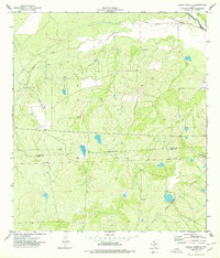
1974 Map of Caiman Creek SE
USGS Topo · Published 1977About this map
The Nueces River winds through the northeastern corner of this South Texas landscape, where the local economy in the mid-1970s was defined by ranching and energy extraction. The terrain is marked by distinctive brush-country features like Monte Cortado and the lowlands of Magueyitos, which slope toward Los Olmos Creek. The presence of a Landing Strip, a series of pipelines, and an Oil Well highlights the region's industrial utility, while local landmarks such as Storage Bins and a Water Tank indicate the infrastructure necessary for managing stock and resources in an arid environment. An Indefinite Boundary runs through the center of the sheet, reflecting the shifting administrative or property lines in the open country between the La Salle and Webb county border.
Find a feature on this map
14 named features on this map. Tap any name to fly to it.
Don’t see what you’re looking for? This feature index may not catch every label — zoom into the map to look around manually.
Map Details
Editions of this 1974 Caiman Creek SE Map
This is the sole edition of this map. No revisions or reprints were ever made.
Other maps of this area

1929 · Cotulla
USGS Topo · 1:125,000

1953 · Crystal City
USGS Topo · 1:250,000

1955 · Crystal City
USGS Topo · 1:250,000

1956 · Becerra
USGS Topo · 1:62,500

1956 · Piedra Creek
USGS Topo · 1:62,500

1956 · Las Mujeres
USGS Topo · 1:62,500

1956 · Laredo
USGS Topo · 1:250,000

1957 · Caiman Creek
USGS Topo · 1:62,500

1961 · Crystal City
USGS Topo · 1:250,000

1968 · Crystal City
USGS Topo · 1:250,000