1960s Maps of Laredo, Texas
Explore 5 historic maps of Laredo from the 1960s. These maps offer a rare glimpse into what life looked like during the 1960s — showing old roads, neighborhoods, homes, and landmarks that have changed or disappeared over time.
Whether you're researching your family's past, planning a metal detecting trip, or studying how Laredo's landscape evolved across the 1960s, these high-resolution maps are a powerful tool for exploring the history of this region.
- Focus on a specific era: All maps on this page are from the 1960s, giving you a focused view of this time period.
- See what’s changed: Compare century-old streets, trails, and buildings to today's modern landscape using overlays and satellite layers.
- Research with precision: Use these maps for genealogy, historical research, land use analysis, or educational projects.
- View, download, or print: Maps are fully viewable online in high resolution, and can be downloaded or printed for your own records.
Start exploring Laredo's history through authentic maps from the 1960s. This is your window into the past.
Laredo, TX maps
(5)- 1965 Map of Laredo West, 1967 Print
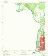 1965 Laredo West1967 Print · USGSLaredo thrived as a vital international gateway in the mid-sixties, centered on the river crossing and the Missouri Pacific rail line. Genealogists and local historians can trace the foundations of the community through Fort Mc Intosh, Santa Maria Ch, and the Holding Institute.3 unique versions available
 - 1965 Map of Orvil, 1967 Print
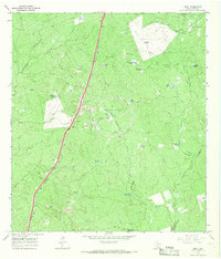 1965 Orvil1967 Print · USGSWebb County ranch lands in the mid-sixties are defined here by the intersection of traditional cattle infrastructure and modern industry. Researchers can trace the Missouri Pacific rail line through Orvil or locate the sprawling Tire Proving Ground.3 unique versions available
 - 1965 Map of Cuervo Creek, 1967 Print
 1965 Cuervo Creek1967 Print · USGSMid-century ranching life in Webb County is captured here as cattle operations relied on the brushy drainages north of the border. Researchers can find the Tordillo Cem, the Retama Ranch, and remnants of an Old Railroad Grade tracing through the landscape.
 - 1965 Map of Dolores Ranch, 1967 Print
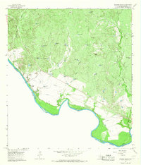 1965 Dolores Ranch1967 Print · USGSThe Texas-Mexico borderlands come into focus in the mid-sixties, capturing the ranching landscape along the Rio Grande. Trace family history at Darwin Cemetery or explore the infrastructure of Dolores Ranch and the Old Railroad Grade.2 unique versions available
 - 1965 Map of Laredo East, 1967 Print
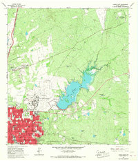 1965 Laredo East1967 Print · USGSLaredo was a hub of military and civic growth in the mid-1960s, centered around its strategic airfield and expanding urban grid. Genealogists and historians can trace the footprints of Ursuline Academy, the sprawling City Cem, and the operations at Laredo Air Force Base.2 unique versions available
End of results
Showing maps 1-5 of 5
Top cities near Laredo
- Rio Bravo historical maps
- El Cenizo historical maps
- La Presa historical maps
- Los Veteranos II historical maps
Top neighborhoods of Laredo
- Los Altos Colonia historical maps
- One River Place Colonia historical maps
- Orvil historical maps
- Las Blancas Colonia historical maps
- Larga Vista Colonia historical maps
- Larga Vista historical maps
See more
Frequently asked questions
- What are the different types of historical maps available for Laredo?
- What is the oldest map of Laredo?
- Where can I purchase historical maps of Laredo for my home or office?
- Where can I download high-res historical maps of Laredo?
- Are there historical topographic maps available for Laredo?
- Is there historical aerial imagery available for Laredo?
- Where are historical maps of Laredo sourced from?