1970s Maps of Laredo, Texas
Explore 3 historic maps of Laredo from the 1970s. These maps offer a rare glimpse into what life looked like during the 1970s — showing old roads, neighborhoods, homes, and landmarks that have changed or disappeared over time.
Whether you're researching your family's past, planning a metal detecting trip, or studying how Laredo's landscape evolved across the 1970s, these high-resolution maps are a powerful tool for exploring the history of this region.
- Focus on a specific era: All maps on this page are from the 1970s, giving you a focused view of this time period.
- See what’s changed: Compare century-old streets, trails, and buildings to today's modern landscape using overlays and satellite layers.
- Research with precision: Use these maps for genealogy, historical research, land use analysis, or educational projects.
- View, download, or print: Maps are fully viewable online in high resolution, and can be downloaded or printed for your own records.
Start exploring Laredo's history through authentic maps from the 1970s. This is your window into the past.
Laredo, TX maps
(3)- 1979 Map of Isla Mesteno
 1979 Isla Mesteno1979 Print · USGSThe Texas-Mexico borderlands come into focus in the late 1970s as the Rio Grande winds past remote ranching settlements and gas fields. Researchers can trace family-named sites like Las Josefinas, the abandoned San Pablo, and the Aduana at La Rivereña.
 - 1979 Map of Laredo South, 1980 Print
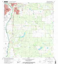 1979 Laredo South1980 Print · USGSThe international border at the end of the 1970s shows the twin cities of Laredo and Nuevo Laredo flanking the Rio Bravo Grande. Researchers can trace rural settlements like Santa Maria (Angelica) and community landmarks like Masterson Sch.2 unique versions available
 - 1979 Map of O'Keefe Lake, 1981 Print
 1979 O'Keefe Lake1981 Print · USGSThe Texas-Mexico borderlands along the Webb and Zapata county lines come into focus in this late-seventies survey. Genealogists and historians can trace small ranching outposts such as Las Josefinas and El Porvenir near the banks of the Falcon Reservoir.
End of results
Showing maps 1-3 of 3
Top cities near Laredo
- Rio Bravo historical maps
- El Cenizo historical maps
- La Presa historical maps
- Los Veteranos II historical maps
Top neighborhoods of Laredo
- Los Altos Colonia historical maps
- One River Place Colonia historical maps
- Orvil historical maps
- Las Blancas Colonia historical maps
- Larga Vista Colonia historical maps
- Larga Vista historical maps
See more
Frequently asked questions
- What are the different types of historical maps available for Laredo?
- What is the oldest map of Laredo?
- Where can I purchase historical maps of Laredo for my home or office?
- Where can I download high-res historical maps of Laredo?
- Are there historical topographic maps available for Laredo?
- Is there historical aerial imagery available for Laredo?
- Where are historical maps of Laredo sourced from?