1960s Maps of Floresville, Texas
Explore 2 historic maps of Floresville from the 1960s. These maps offer a rare glimpse into what life looked like during the 1960s — showing old roads, neighborhoods, homes, and landmarks that have changed or disappeared over time.
Whether you're researching your family's past, planning a metal detecting trip, or studying how Floresville's landscape evolved across the 1960s, these high-resolution maps are a powerful tool for exploring the history of this region.
- Focus on a specific era: All maps on this page are from the 1960s, giving you a focused view of this time period.
- See what’s changed: Compare century-old streets, trails, and buildings to today's modern landscape using overlays and satellite layers.
- Research with precision: Use these maps for genealogy, historical research, land use analysis, or educational projects.
- View, download, or print: Maps are fully viewable online in high resolution, and can be downloaded or printed for your own records.
Start exploring Floresville's history through authentic maps from the 1960s. This is your window into the past.
Floresville, TX maps
(2)- 1961 Map of Dewees, 1963 Print
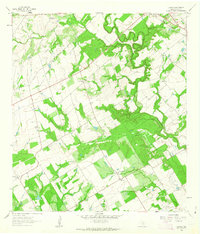 1961 Dewees1963 Print · USGSThe ranching country of Wilson County is captured here in the early sixties, showing the San Antonio River valley before modern development. Genealogists can trace family landmarks like Dewees Ranch, Loma Vista, and the Sacred Heart Cem.2 unique versions available
 - 1961 Map of Floresville, 1963 Print
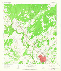 1961 Floresville1963 Print · USGSThe Wilson County seat and its surrounding river valley are captured here in the early sixties as the local economy balanced rail commerce with oil exploration. Genealogists and historians can locate the Casa Blanca Historical Marker, the old Lodi Sch, and the winding course of Kiester Creek.2 unique versions available
End of results
Showing maps 1-2 of 2
Top cities near Floresville
- San Antonio historical maps
- Poth historical maps
- Saint Hedwig historical maps
- Elmendorf historical maps
- Stockdale historical maps
- La Vernia historical maps
See more
Frequently asked questions
- What are the different types of historical maps available for Floresville?
- What is the oldest map of Floresville?
- Where can I purchase historical maps of Floresville for my home or office?
- Where can I download high-res historical maps of Floresville?
- Are there historical topographic maps available for Floresville?
- Is there historical aerial imagery available for Floresville?
- Where are historical maps of Floresville sourced from?