1960s Maps of Winkler County, Texas
Explore 7 historic maps of Winkler County from the 1960s. These maps offer a rare glimpse into what life looked like during the 1960s — showing old roads, neighborhoods, homes, and landmarks that have changed or disappeared over time.
Whether you're researching your family's past, planning a metal detecting trip, or studying how Winkler County's landscape evolved across the 1960s, these high-resolution maps are a powerful tool for exploring the history of this region.
- Focus on a specific era: All maps on this page are from the 1960s, giving you a focused view of this time period.
- See what’s changed: Compare century-old streets, trails, and buildings to today's modern landscape using overlays and satellite layers.
- Research with precision: Use these maps for genealogy, historical research, land use analysis, or educational projects.
- View, download, or print: Maps are fully viewable online in high resolution, and can be downloaded or printed for your own records.
Start exploring Winkler County's history through authentic maps from the 1960s. This is your window into the past.
Winkler County, TX maps
(7)- 1968 Map of Cowden Place, 1971 Print
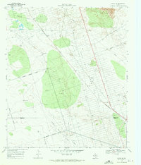
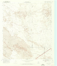 1968 Cowden Place1971 Print · USGSThe West Texas dunes and oil fields come into focus in the late sixties at the borders of Winkler, Ector, and Ward Counties. Researchers can trace the water and oil infrastructure of the era through sites like Cowden Place, Little Diamond Windmill, and Williams Ranch.
 - 1968 Map of Wink South, 1971 Print
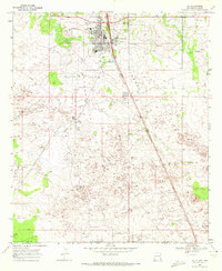
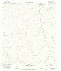 1968 Wink South1971 Print · USGSWinkler County ranching and petroleum interests intersect in the Permian Basin during the late sixties. Researchers can trace the layout of the Old Railroad Grade and locate named rural landmarks like Oats Windmill and the Waldron site.2 unique versions available
 - 1968 Map of Soda Lake NE, 1971 Print
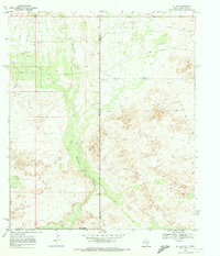
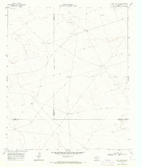 1968 Soda Lake NE1971 Print · USGSWinkler County ranching and oil operations are captured in the late sixties at the intersection of three West Texas counties. Researchers can trace historic water infrastructure and early petroleum sites like Little Joe Oil Field, China Windmill, and Bachelor Windmill.2 unique versions available
 - 1968 Map of China Ranch, 1971 Print
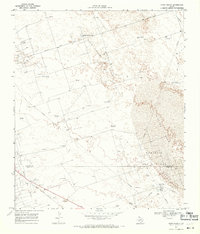 1968 China Ranch1971 Print · USGSThe high desert of Winkler and Ward counties is shown here during the peak of the late-sixties oil boom. Researchers can trace the industrial footprint of Halley Field, the Texas New Mexico railroad, and family-named landmarks like China Ranch and Mitchell Windmill.2 unique versions available
 - 1969 Map of Pyote NE, 1971 Print
 1969 Pyote NE1971 Print · USGSWinkler and Ward Counties are defined by the mid-century petroleum boom in these expansive West Texas oil fields. Researchers can trace the industrial footprint of the Halley Oil Field and locate remote water sources like Red Tank Windmill and Wildcat Windmill.
 - 1969 Map of Jal, 1972 Print
 1969 Jal1972 Print · USGSSoutheast New Mexico in the late sixties is defined here by the industrial infrastructure of the oil and gas fields. Researchers can trace the town layout of Jal, find the old Drive-in Theater, and follow the Texas New Mexico rail line as it heads toward the border.2 unique versions available
 - 1969 Map of Jal SE, 1973 Print
 1969 Jal SE1973 Print · USGSThe high desert of the Permian Basin comes into focus during the late sixties at the New Mexico and Texas border. Petroleum historians and researchers can trace the industrial footprint of the Dollarhide Oil Field and topographic features like Monument Draw and Shifting Sand.2 unique versions available
End of results
Showing maps 1-7 of 7
Top cities of Winkler County
Frequently asked questions
- What are the different types of historical maps available for Winkler County?
- What is the oldest map of Winkler County?
- Where can I purchase historical maps of Winkler County for my home or office?
- Where can I download high-res historical maps of Winkler County?
- Are there historical topographic maps available for Winkler County?
- Is there historical aerial imagery available for Winkler County?
- Where are historical maps of Winkler County sourced from?