1900s (20th Century) Maps of Antimony, Utah
Explore 11 historic maps of Antimony from the 1900s (20th Century). These maps offer a rare glimpse into what life looked like during the 1900s — showing old roads, neighborhoods, homes, and landmarks that have changed or disappeared over time.
Whether you're researching your family's past, planning a metal detecting trip, or studying how Antimony's landscape evolved across the 1900s, these high-resolution maps are a powerful tool for exploring the history of this region.
- Focus on a specific era: All maps on this page are from the 1900s, giving you a focused view of this time period.
- See what’s changed: Compare century-old streets, trails, and buildings to today's modern landscape using overlays and satellite layers.
- Research with precision: Use these maps for genealogy, historical research, land use analysis, or educational projects.
- View, download, or print: Maps are fully viewable online in high resolution, and can be downloaded or printed for your own records.
Start exploring Antimony's history through authentic maps from the 1900s. This is your window into the past.
Antimony, UT maps
(11)- 1953 Map of Richfield, 1963 Print
 1953 Richfield1963 Print · USGSCentral Utah in the early fifties reveals a complex geography of high plateaus and desert basins tied together by the Union Pacific rail lines. Genealogists and historians can trace family roots in Richfield or Kanosh and locate remote operations like the Blue Star Mine or Newhouse.3 unique versions available
 - 1956 Map of Salina
 1956 Salina1956 Print · USGSCentral Utah in the mid-fifties reveals a landscape of high plateaus and desert basins before the modern highway era. Researchers can trace the ranching and mining roots of Hanksville and Loa or locate the Lucky Strike Mine near the San Rafael Swell.5 unique versions available
 - 1958 Map of Richfield
 1958 Richfield1958 Print · USGSCentral Utah in the late fifties shows a landscape of mountain forests and desert basins connected by the Union Pacific Railroad. Genealogists and historians can trace rail stops at Nada Station, mines like the Blue Star Mine, and tribal lands of the Paiute Indian Reservation.2 unique versions available
 - 1960 Map of Salina
 1960 Salina1960 Print · USGSThe high plateaus and canyonlands of south-central Utah appear in the early sixties as a region of remote ranching towns and developing parklands. Researchers can trace historic settlements like Fruita and Loa or locate the uranium mines and the tracks of the Denver and Rio Grande Western RR.2 unique versions available
 - 1962 Map of Salina
 1962 Salina1962 Print · USGSSevier County and the surrounding desert wilderness appear here in the early sixties as a network of isolated river valley towns and high-altitude forests. Researchers can locate remote landmarks like Fruita, trace the Denver & Rio Grande Western RR, and find backcountry sites like the Aquarius Ranger Station.
 - 1970 Map of Angle, 1972 Print
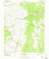
 1970 Angle1972 Print · USGSThe high plateau country of south-central Utah is captured here in the early 1970s, as ranching and water management shaped the Piute and Garfield County line. Trace local landmarks like Nicks Cabin, the waters of Otter Creek Reservoir, and the high-altitude Bedspring Pass.
 - 1970 Map of Antimony, 1972 Print
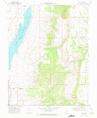
 1970 Antimony1972 Print · USGSThe town of Antimony and the Sevier River valley are captured here in the early seventies, just as the region's ranching and water infrastructure reached a modern peak. Genealogists and researchers can trace the Antimony Cem, locate old Landing Strips, and find the Mill (Ruins) near the national forest boundary.2 unique versions available
 - 1971 Map of Phonolite Hill, 1974 Print
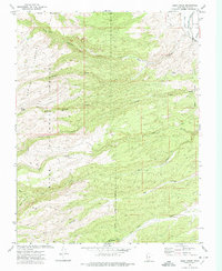
 1971 Phonolite Hill1974 Print · USGSThe high plateaus of Piute and Garfield counties are captured here in the early seventies during a period of active forest management and water engineering. Genealogists and historians can trace family-named landmarks like Sams Cabin, Hodge Ranch Spring, and the waterways near Otter Creek Reservoir.
 - 1971 Map of Deep Creek, 1974 Print
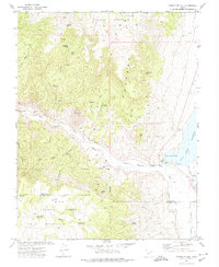
 1971 Deep Creek1974 Print · USGSThe high plateau country of Garfield County is captured here in the early 1970s, as the wilderness slopes meet the Sevier River valley. Researchers can trace the water systems of the East Fork and Canal near Antimony or follow trails through Pole Canyon and the Dixie National Forest.
 - 1980 Map of Loa
 1980 Loa1980 Print · USGSCentral Utah's high plateaus and the Fremont River corridor are captured here during the 1980s, showcasing a landscape of high-elevation reservoirs and remote ranching outposts. Genealogists can trace family names and early settlements from Loa and Teasdale to the orchards of Fruita.2 unique versions available
 - 1980 Map of Beaver, 1981 Print
 1980 Beaver1981 Print · USGSSouthern Utah at the start of the 1980s reveals a rugged landscape of high mountain plateaus and essential desert irrigation networks. Researchers can trace the path of the Denver and Rio Grande Western through Marysvale or locate local landmarks like the Deer Trail Mine and Puffer Lake.2 unique versions available
End of results
Showing maps 1-11 of 11
Top cities near Antimony
Frequently asked questions
- What are the different types of historical maps available for Antimony?
- What is the oldest map of Antimony?
- Where can I purchase historical maps of Antimony for my home or office?
- Where can I download high-res historical maps of Antimony?
- Are there historical topographic maps available for Antimony?
- Is there historical aerial imagery available for Antimony?
- Where are historical maps of Antimony sourced from?