
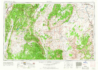
1956 Map of Salina
USGS Topo · Published 1956About this map
The San Rafael Swell dominates the central landscape of this 1950s survey, illustrating a geological transition from the high plateaus of the Fish Lake National Forest to the desert basins of the Green River. Human activity is concentrated along the river corridors, where settlements like Hanksville, Torrey, and Loa serve as gateways to the isolated terrain of Capitol Reef National Monument. At this time, resource extraction is a visible part of the economy, evidenced by the Lucky Strike Mine (abandoned) and scattered oil test holes in the San Rafael Reef. The rail network is represented by the Denver & Rio Grande Western RR skirting the northern edges, while the Dirty Devil River and Fremont River carve drainage patterns across the Aquarius Plateau and the Middle Desert.
Find a feature on this map
148 named features on this map. Tap any name to fly to it.
Don’t see what you’re looking for? This feature index may not catch every label — zoom into the map to look around manually.
Map Details
Editions of this 1956 Salina Map
5 editions found
Other maps of this area

1885 · San Rafael
USGS Topo · 1:250,000

1885 · Manti
USGS Topo · 1:250,000

1885 · East Tavaputs
USGS Topo · 1:250,000

1885 · La Sal
USGS Topo · 1:250,000

1885 · Beaver
USGS Topo · 1:250,000

1885 · Sevier Desert
USGS Topo · 1:250,000

1885 · Fish Lake
USGS Topo · 1:250,000

1886 · Kanab
USGS Topo · 1:250,000

1886 · Escalante
USGS Topo · 1:250,000

1886 · Henry Mountains
USGS Topo · 1:250,000