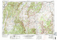
1956 Map of Salina
USGS Topo · Published 1977About this map
Salina sits at the western edge of this mid-century landscape where the Sevier River and Salina Creek meet, marking a vital junction for the Denver and Rio Grande Western RR. The terrain transitions from the high elevations of the Wasatch Plateau and Fish Lake Plateau in the west to the deeply eroded formations of Capitol Reef and the Middle Desert toward the east. This 1970 revision records the emergence of Interstate 70 alongside older routes like Utah 24, illustrating the modernization of transport through the canyonlands.
Find a feature on this map
169 named features on this map. Tap any name to fly to it.
Don’t see what you’re looking for? This feature index may not catch every label — zoom into the map to look around manually.
Map Details
Editions of this 1956 Salina Map
5 editions found

Other maps of this area

1885 · San Rafael
USGS Topo · 1:250,000

1885 · Manti
USGS Topo · 1:250,000

1885 · East Tavaputs
USGS Topo · 1:250,000

1885 · La Sal
USGS Topo · 1:250,000

1885 · Beaver
USGS Topo · 1:250,000

1885 · Sevier Desert
USGS Topo · 1:250,000

1885 · Fish Lake
USGS Topo · 1:250,000

1886 · Kanab
USGS Topo · 1:250,000

1886 · Escalante
USGS Topo · 1:250,000

1886 · Henry Mountains
USGS Topo · 1:250,000