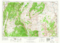
1956 Map of Salina
USGS Topo · Published 1967About this map
Capitol Reef National Monument and the massive geological uplift of the Waterpocket Fold dominate this mid-century portrait of south-central Utah. The map details a landscape where high alpine lakes meet the arid sandstone of the San Rafael Swell and the Henry Mountains. Settled areas like Salina and Loa are contrastingly clustered near water sources like Salina Creek and the Fremont River, while the eastern reaches show the path of the Denver and Rio Grande Western RR crossing the Green River.
Find a feature on this map
50 named features on this map. Tap any name to fly to it.
Don’t see what you’re looking for? This feature index may not catch every label — zoom into the map to look around manually.
Map Details
Editions of this 1956 Salina Map
5 editions found

Other maps of this area

1885 · San Rafael
USGS Topo · 1:250,000

1885 · Manti
USGS Topo · 1:250,000

1885 · East Tavaputs
USGS Topo · 1:250,000

1885 · La Sal
USGS Topo · 1:250,000

1885 · Beaver
USGS Topo · 1:250,000

1885 · Sevier Desert
USGS Topo · 1:250,000

1885 · Fish Lake
USGS Topo · 1:250,000

1886 · Kanab
USGS Topo · 1:250,000

1886 · Escalante
USGS Topo · 1:250,000

1886 · Henry Mountains
USGS Topo · 1:250,000