1900s (20th Century) Maps of Moab, Utah
Explore 10 historic maps of Moab from the 1900s (20th Century). These maps offer a rare glimpse into what life looked like during the 1900s — showing old roads, neighborhoods, homes, and landmarks that have changed or disappeared over time.
Whether you're researching your family's past, planning a metal detecting trip, or studying how Moab's landscape evolved across the 1900s, these high-resolution maps are a powerful tool for exploring the history of this region.
- Focus on a specific era: All maps on this page are from the 1900s, giving you a focused view of this time period.
- See what’s changed: Compare century-old streets, trails, and buildings to today's modern landscape using overlays and satellite layers.
- Research with precision: Use these maps for genealogy, historical research, land use analysis, or educational projects.
- View, download, or print: Maps are fully viewable online in high resolution, and can be downloaded or printed for your own records.
Start exploring Moab's history through authentic maps from the 1900s. This is your window into the past.
Moab, UT maps
(10)- 1956 Map of Moab, 1972 Print
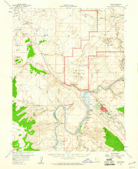
 1956 Moab1972 Print · USGSThe Colorado Plateau and La Sal Mountains appear here in the mid-fifties, just as the uranium boom and energy exploration were reshaping the Four Corners. Researchers can trace the Denver and Rio Grande Western through Cisco or locate the remote outpost of Uravan and Looking Glass Rock.3 unique versions available
 - 1959 Map of Moab
 1959 Moab1959 Print · USGSSoutheast Utah and Western Colorado are mapped here in the late fifties, just as the uranium boom was transforming the remote canyon lands. Genealogists and historians can trace the foundations of Moab and Nucla, or locate mining sites and landmarks like Uravan and Dead Horse Point.
 - 1959 Map of Moab, 1960 Print
 1959 Moab1960 Print · USGSMid-century Moab and the surrounding canyonlands are documented here just as the uranium boom and desert tourism began to shape the region. Search for local landmarks like the Elk Mtn Mission Historical Mon, the Ore Reduction Plant, and the natural wonders of Arches National Monument.3 unique versions available
 - 1959 Map of Moab 4 SE, 1961 Print
 1959 Moab 4 SE1961 Print · USGSMoab and the surrounding red rock country are captured during a period of industrial mining and emerging tourism in the late fifties. Researchers can trace the mid-century footprint of Moab, the Ore Reduction Plant, and ancient Petroglyphs along the Colorado River.
 - 1960 Map of Moab
 1960 Moab1960 Print · USGSThe canyonlands and high plateaus of the Utah-Colorado border are shown here during the mid-century uranium boom. Researchers can trace the river-and-rail corridors of the Colorado River and the Denver and Rio Grande Western near Moab and Uravan.3 unique versions available
 - 1962 Map of Moab
 1962 Moab1962 Print · USGSThe canyon country of southeastern Utah and western Colorado is captured here in the early sixties, showing the reach of the Denver and Rio Grande Western through the desert. Researchers can trace the layout of mining settlements like Uravan and old railroad stops at Cisco and Sagers Station.
 - 1964 Map of Moab
 1964 Moab1964 Print · USGSThe canyonlands of eastern Utah and western Colorado are captured here in the mid-1960s, a time when uranium mining shaped the local economy. Researchers can trace the river-and-rail network through Sinbad Valley and locate mining outposts like Uravan and Vancorum.
 - 1965 Map of Moab
 1965 Moab1965 Print · USGSSoutheast Utah and Western Colorado are mapped here in the mid-sixties, showcasing a landscape of high plateaus and deep river canyons. Genealogists and historians can trace the mining-era towns of Uravan and Paradox or locate remote landmarks like Castleton and Dead Horse Point.
 - 1983 Map of Moab
 1983 Moab1983 Print · USGSThe Colorado River corridor near Moab is captured here in the early eighties, showcasing a landscape of uranium mining and iconic parklands. Trace the Denver and Rio Grande Western RR as it passes through Cisco or locate landmarks like Delicate Arch and the Telluride Mines.3 unique versions available
 - 1985 Map of Moab, 1986 Print
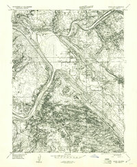
 1985 Moab1986 Print · USGSThe growing town of Moab is captured here in the mid-1980s, situated between the Colorado River and the red rock canyons of Arches National Park. Researchers can trace local landmarks and water sources like Jackson Reservoir, Matrimony Spring, and the nearby settlement of Emkay.3 unique versions available
End of results
Showing maps 1-10 of 10
Top cities near Moab
Frequently asked questions
- What are the different types of historical maps available for Moab?
- What is the oldest map of Moab?
- Where can I purchase historical maps of Moab for my home or office?
- Where can I download high-res historical maps of Moab?
- Are there historical topographic maps available for Moab?
- Is there historical aerial imagery available for Moab?
- Where are historical maps of Moab sourced from?