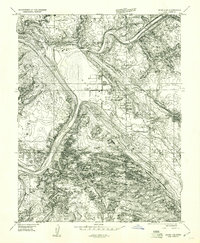
1959 Map of Moab 4 SE
USGS Topo · Published 1961About this map
Moab sits at a critical geological junction where the Colorado River cuts through the red rock landscape of the Moab Valley. This late 1950s survey documents the community's industrial era, specifically highlighting the Ore Reduction Plant and a Mill, reflecting the region's mid-century mining boom. Cultural history is visible in the ancient Petroglyphs near the riverbanks and the contemporary mid-century Drive-in Theater on the outskirts of town. The transition from the high desert of Arches National Monument to the fertile stretches of Spanish Valley is clearly delineated. Notable local landmarks like Matrimony Spring and The Portal mark the physical boundaries of the settlement, while the presence of a Landing Strip and Monument Headquarters indicates the growing intersection of industry and tourism in the post-war West.
Find a feature on this map
30 named features on this map. Tap any name to fly to it.
Don’t see what you’re looking for? This feature index may not catch every label — zoom into the map to look around manually.
Map Details
Editions of this 1959 Moab 4 SE Map
This is the sole edition of this map. No revisions or reprints were ever made.
Other maps of this area

1885 · La Sal
USGS Topo · 1:250,000

1952 · Moab 4 NW
USGS Topo · 1:24,000

1952 · Moab 4 SW
USGS Topo · 1:24,000

1954 · Mt Peale 2 NW
USGS Topo · 1:24,000

1954 · Carlisle 1 NE
USGS Topo · 1:24,000

1954 · Carlisle 1 NW
USGS Topo · 1:24,000

1954 · Mt. Waas 3 NW
USGS Topo · 1:24,000

1954 · Mt. Waas 3 SW
USGS Topo · 1:24,000

1954 · La Sal Junction
USGS Topo · 1:62,500

1954 · Castle Valley
USGS Topo · 1:62,500