1970s Maps of Parowan, Utah
Explore 2 historic maps of Parowan from the 1970s. These maps offer a rare glimpse into what life looked like during the 1970s — showing old roads, neighborhoods, homes, and landmarks that have changed or disappeared over time.
Whether you're researching your family's past, planning a metal detecting trip, or studying how Parowan's landscape evolved across the 1970s, these high-resolution maps are a powerful tool for exploring the history of this region.
- Focus on a specific era: All maps on this page are from the 1970s, giving you a focused view of this time period.
- See what’s changed: Compare century-old streets, trails, and buildings to today's modern landscape using overlays and satellite layers.
- Research with precision: Use these maps for genealogy, historical research, land use analysis, or educational projects.
- View, download, or print: Maps are fully viewable online in high resolution, and can be downloaded or printed for your own records.
Start exploring Parowan's history through authentic maps from the 1970s. This is your window into the past.
Parowan, UT maps
(2)- 1971 Map of Summit, 1975 Print
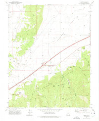 1971 Summit1975 Print · USGSIron County in the early 1970s shows a landscape of high desert water management and rural industry. You can trace the development of Summit and find specialized landmarks like the Cinder Pit near Cinder Hill or the historic Cem on the valley's edge.
 - 1971 Map of Parowan, 1975 Print
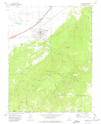 1971 Parowan1975 Print · USGSParowan and the surrounding valley are captured in the early seventies as the community balanced its agricultural roots with forest recreation. Trace local landmarks from the City Airport to the high camps at Vermillion Castle Campground and Yankee Meadows Reservoir.2 unique versions available
End of results
Showing maps 1-2 of 2
Top cities near Parowan
- Cedar City historical maps
- Enoch historical maps
- Paragonah historical maps
- Summit historical maps
- Brian Head historical maps
Frequently asked questions
- What are the different types of historical maps available for Parowan?
- What is the oldest map of Parowan?
- Where can I purchase historical maps of Parowan for my home or office?
- Where can I download high-res historical maps of Parowan?
- Are there historical topographic maps available for Parowan?
- Is there historical aerial imagery available for Parowan?
- Where are historical maps of Parowan sourced from?