1970s Maps of Piute County, Utah
Explore 3 historic maps of Piute County from the 1970s. These maps offer a rare glimpse into what life looked like during the 1970s — showing old roads, neighborhoods, homes, and landmarks that have changed or disappeared over time.
Whether you're researching your family's past, planning a metal detecting trip, or studying how Piute County's landscape evolved across the 1970s, these high-resolution maps are a powerful tool for exploring the history of this region.
- Focus on a specific era: All maps on this page are from the 1970s, giving you a focused view of this time period.
- See what’s changed: Compare century-old streets, trails, and buildings to today's modern landscape using overlays and satellite layers.
- Research with precision: Use these maps for genealogy, historical research, land use analysis, or educational projects.
- View, download, or print: Maps are fully viewable online in high resolution, and can be downloaded or printed for your own records.
Start exploring Piute County's history through authentic maps from the 1970s. This is your window into the past.
Piute County, UT maps
(3)- 1970 Map of Angle, 1972 Print
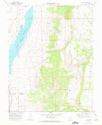 1970 Angle1972 Print · USGSThe high plateau country of south-central Utah is captured here in the early 1970s, as ranching and water management shaped the Piute and Garfield County line. Trace local landmarks like Nicks Cabin, the waters of Otter Creek Reservoir, and the high-altitude Bedspring Pass.
 - 1971 Map of Phonolite Hill, 1974 Print
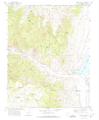 1971 Phonolite Hill1974 Print · USGSThe high plateaus of Piute and Garfield counties are captured here in the early seventies during a period of active forest management and water engineering. Genealogists and historians can trace family-named landmarks like Sams Cabin, Hodge Ranch Spring, and the waterways near Otter Creek Reservoir.
 - 1971 Map of Circleville Mtn, 1975 Print
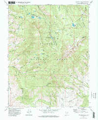 1971 Circleville Mtn1975 Print · USGSHigh in the Tushar Mountains during the early seventies, this survey captures a landscape of remote camps and vital water reservoirs. Researchers can trace historic trails to family landmarks like Fullmers Cabins, Briggs Camp, and Wards Cache.2 unique versions available
End of results
Showing maps 1-3 of 3
Top cities of Piute County
- Circleville historical maps
- Marysvale historical maps
- Junction historical maps
- Kingston historical maps
Frequently asked questions
- What are the different types of historical maps available for Piute County?
- What is the oldest map of Piute County?
- Where can I purchase historical maps of Piute County for my home or office?
- Where can I download high-res historical maps of Piute County?
- Are there historical topographic maps available for Piute County?
- Is there historical aerial imagery available for Piute County?
- Where are historical maps of Piute County sourced from?