1940s Maps of Piute County, Utah
Explore 5 historic maps of Piute County from the 1940s. These maps offer a rare glimpse into what life looked like during the 1940s — showing old roads, neighborhoods, homes, and landmarks that have changed or disappeared over time.
Whether you're researching your family's past, planning a metal detecting trip, or studying how Piute County's landscape evolved across the 1940s, these high-resolution maps are a powerful tool for exploring the history of this region.
- Focus on a specific era: All maps on this page are from the 1940s, giving you a focused view of this time period.
- See what’s changed: Compare century-old streets, trails, and buildings to today's modern landscape using overlays and satellite layers.
- Research with precision: Use these maps for genealogy, historical research, land use analysis, or educational projects.
- View, download, or print: Maps are fully viewable online in high resolution, and can be downloaded or printed for your own records.
Start exploring Piute County's history through authentic maps from the 1940s. This is your window into the past.
Piute County, UT maps
(5)- 1940 Map of Monroe, 1957 Print
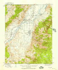 1940 Monroe1957 Print · USGSThe Sevier River valley was a thriving corridor of rail and irrigation just before the mid-century. Researchers can trace the path of the Denver and Rio Grande Western Railroad through Monroe or locate the Antelope Mine and Poverty Flat Ranch.2 unique versions available
 - 1943 Map of Delano Peak
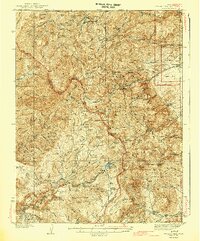 1943 Delano Peak1943 Print · USGSThe Tushar Mountains of Piute and Sevier counties appear here during the mid-twentieth century peak of forest management and mining. Researchers can trace historic extraction sites like the Sevier Mine and Copper Belt Mine or locate early outposts such as the Delano Ranger Station.2 unique versions available
 - 1944 Map of Monroe
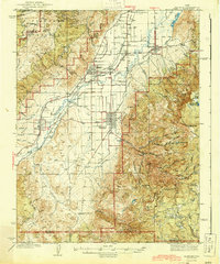 1944 Monroe1944 Print · USGSThe Sevier River Valley thrived as a hub of irrigation and rail transport in the mid-twentieth century. Genealogists and historians can trace the foundations of Monroe, Elsinore, and Annabella alongside the ANTELOPE MINE and Poverty Flat Ranch.
 - 1945 Map of Marysvale, 1956 Print
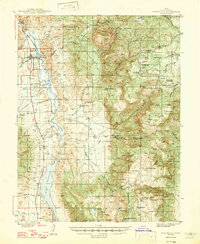
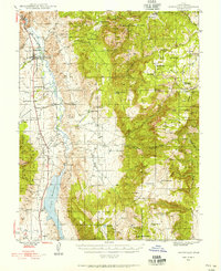 1945 Marysvale1956 Print · USGSPiute County at mid-century reveals a landscape defined by the Sevier River and the mining industry. Trace the Denver & Rio Grande Western rail line through Marysvale to industrial sites like Alunite and the remote Whitehorse Mine.3 unique versions available
 - 1947 Map of Marysvale
 1947 Marysvale1947 Print · USGSPiute County is shown here during the post-war era as a center for mining, rail, and reservoir management. Researchers can locate the Rio Grande Western RR terminus at Marysvale, the Whitehorse Mine, and the southern community of Junction.3 unique versions available
End of results
Showing maps 1-5 of 5
Top cities of Piute County
- Circleville historical maps
- Marysvale historical maps
- Junction historical maps
- Kingston historical maps
Frequently asked questions
- What are the different types of historical maps available for Piute County?
- What is the oldest map of Piute County?
- Where can I purchase historical maps of Piute County for my home or office?
- Where can I download high-res historical maps of Piute County?
- Are there historical topographic maps available for Piute County?
- Is there historical aerial imagery available for Piute County?
- Where are historical maps of Piute County sourced from?