Old Maps of San Juan County, Utah for Genealogy
Trace your family roots with 643 historic maps of San Juan County. These high-res maps reveal old neighborhoods, homesites, landmarks, and streets — helping you uncover where your ancestors lived and how the area evolved over time.
- Explore historic neighborhoods: Identify where your relatives may have lived in the 1800s or 1900s.
- Compare maps over time: Trace the changes in streets, buildings, and landmarks for multi-generational research.
- Perfect for genealogy & ancestry research: Used by family historians and researchers to map out lineage and migration.
These maps are an incredible resource for exploring your personal connection to San Juan County's past.
San Juan County, UT maps
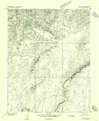
(643)- 1883 Map of Marsh Pass
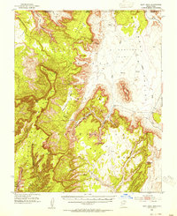
 1883 Marsh Pass1883 Print · USGSNortheastern Arizona was a complex labyrinth of mesas and canyons when this survey was conducted in the early 1880s. Researchers can locate critical desert water sources like Na-pai-bi-to Spring Lake and landmarks like Aga-thla Needle.
 - 1885 Map of San Rafael
 1885 San Rafael1885 Print · USGSCentral Utah at the height of the Powell Survey reveals a land defined by water and stone. Genealogists and historians can locate early settlements like Tidwell and Blake or trace the intricate river systems of Labyrinth Canyon and San Rafael Valley.5 unique versions available
 - 1885 Map of La Sal
 1885 La Sal1885 Print · USGSSoutheast Utah in the mid-1880s remains a frontier of dramatic river canyons and high mountain peaks. Genealogists and historians can trace the early footprints of Moab and Plainfield or locate the high summits of Mt Peale and the path of the Green River.6 unique versions available
 - 1886 Map of Escalante
 1886 Escalante1886 Print · USGSSouthern Utah in the late 1880s was a landscape of formidable geological barriers and isolated river crossings. Modern researchers can trace the early layout of Escalante and identify historic points like The Crossing of the Fathers and Potato Valley.5 unique versions available
 - 1886 Map of Henry Mountains
 1886 Henry Mountains1886 Print · USGSSouthern Utah remains a wilderness of deep canyons and volcanic peaks in this 1880s survey. Researchers can trace the original courses of the Colorado River through Cataract Canyon and find landmarks like Navajo Mt and Monument Valley.
 - 1886 Map of Abajo
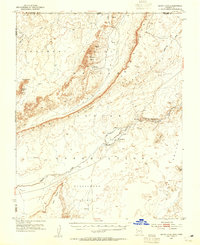
 1886 Abajo1886 Print · USGSSoutheastern Utah appears here in the late frontier era, centered on the early settlement of Bluff City along the San Juan River. Researchers can trace the path of the Old Spanish Trail or locate remote landmarks like Orejas del Oso and Abajo Peak.
 - 1892 Map of Marsh Pass
 1892 Marsh Pass1892 Print · USGSNortheastern Arizona and the Navajo lands are shown in the late nineteenth century as a series of immense mesas and critical water sources. You can trace early trails through Marsh Pass and locate remote landmarks like the Agathla Needle or Chil-Chi-Vi-To Spring.4 unique versions available
 - 1892 Map of Abajo
 1892 Abajo1892 Print · USGSSoutheastern Utah in the 1890s remained a remote frontier where settlement followed the river and historic paths. Researchers can trace early routes like the Old Spanish Trail and find the riverside location of Bluff City below the Abajo Mts.
 - 1892 Map of Henry Mountains
 1892 Henry Mountains1892 Print · USGSSouthern Utah in the late 1800s remains a wilderness of deep canyons and isolated peaks under the direction of J.W. Powell. Geologists and historians can trace the geological spine of the Water Pocket Fold and the early boundaries of the Navajo Indian Res. near Monument Valley.6 unique versions available
 - 1892 Map of Canyon De Chelly
 1892 Canyon De Chelly1892 Print · USGSApache County's high desert and deep sandstone canyons are documented here in the early 1890s, shortly after the initial 1883 survey. Modern researchers can trace the intricate drainages of Canyon De Chelly and find early water sources like Hospitito Spring and Tatezaka Tank.5 unique versions available
 - 1893 Map of Abajo
 1893 Abajo1893 Print · USGSSoutheastern Utah and the Colorado border are documented in the late nineteenth century during a time of early settlement and regional surveying. Researchers can trace the path of the Old Spanish Trail and locate early sites like Bluff City near the Navajo Indian Res. Line.5 unique versions available
 - 1922 Map of Warm Creek
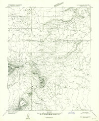
 1922 Warm Creek1922 Print · USGSSouthern Utah's canyon country appears here in the early twenties, just as the first formal topographic surveys reached the Colorado River. Researchers can trace the legendary Crossing of the Fathers and locate the remote Warm Creek Cabin near the Utah-Arizona Boundary Line.
 - 1935 Map of Elk Ridge
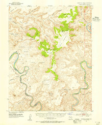
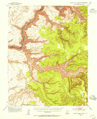
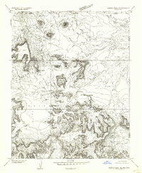
 1935 Elk Ridge1935 Print · USGSSan Juan County in the mid-1930s is a rugged expanse of high mesas and forest ranger stations. Researchers can locate remote cattle operations like Stirrup Ranch and early archaeological sites including the Owachomo Bridge and various Cliff Dwelling locations.2 unique versions available
 - 1940 Map of Elk Ridge
 1940 Elk Ridge1940 Print · USGSSoutheast Utah is shown just before the war as a landscape of remote cattle ranches and ancient archaeology. Genealogists and historians can locate family holdings like Wilson Ranch or explore the early layout of Natural Bridges National Monument and the town of Blanding.2 unique versions available
 - 1951 Map of Upheaval Dome, 1955 Print
 1951 Upheaval Dome1955 Print · USGSThe confluence region of the Green and Colorado Rivers is captured here in the early 1950s, documenting a remote wilderness of canyons and high mesas. Researchers can locate ancient Cliff Dwellings near Aztec Butte or trace the intricate river bends at Turks Head and Goose Neck.3 unique versions available
 - 1952 Map of Clay Hills 4 SW
 1952 Clay Hills 4 SW1952 Print · USGSSan Juan County in the early fifties reveals a remote landscape where tradition meets industry on the Navajo Indian Reservation. Researchers can trace the layout of the Goulding Trading Post, the remote Skyline Mine, and scattered dwellings labeled simply as Hogans.2 unique versions available
 - 1952 Map of Clay Hills 3 SE, 1954 Print
 1952 Clay Hills 3 SE1954 Print · USGSThe Navajo Indian Reservation in the early fifties shows a landscape of traditional dwellings and remote trading outposts. Researchers can locate several Hogans and the Oljeto Trading Post, or trace the Horse Trail beneath Holliday Mesa.
 - 1952 Map of Agathla Peak 1 NW, 1954 Print
 1952 Agathla Peak 1 NW1954 Print · USGSThe Navajo Nation's high desert landscape is captured in the early fifties, documenting a region of massive buttes and ancient archaeological sites. Researchers can locate significant landmarks like the Ruin Pueblo (Site), the House of Hands, and Mitchell Butte.
 - 1952 Map of Bluff 3 SE, 1954 Print
 1952 Bluff 3 SE1954 Print · USGSThe Navajo reservation in San Juan County during the early fifties shows a world of traditional habitation and desert navigation. Researchers can trace land use patterns via a specific Hogan site, historical Jeep Trails, and water sources like Spring and Cane Valley Wash.
 - 1952 Map of Mouth of Dark Canyon, 1954 Print
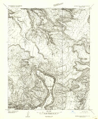
 1952 Mouth of Dark Canyon1954 Print · USGSCataract Canyon and the Colorado River dominate this San Juan County landscape in the early fifties. Researchers can trace remote desert landmarks like Indian Head Pass, find Freddies Cistern, and locate the Dark Canyon Rapids.3 unique versions available
 - 1952 Map of Dinnehotso, 1954 Print
 1952 Dinnehotso1954 Print · USGSThe high desert of the Navajo Nation comes to life in the early fifties, documenting a landscape of isolated trading posts and uranium-era mining. Locate family-named landmarks like Yazzie Mesa or trace the early workings at Monument No 2 Mine.3 unique versions available
 - 1952 Map of Agathla Peak 2 NW, 1954 Print
 1952 Agathla Peak 2 NW1954 Print · USGSThe high desert borderlands of the Arizona-Utah line appear in detailed relief in the early fifties, just as aerial photogrammetry was transforming western mapping. Researchers can trace the rugged topography of Skeleton Mesa and landmarks like Big Point or Todicheenie Bench.
 - 1952 Map of Boot Mesa, 1954 Print
 1952 Boot Mesa1954 Print · USGSThe Navajo Indian Reservation and Monument Valley appear here in the early fifties, before modern development reached these remote canyonlands. Researchers can locate significant archaeological sites like Keet Seel Ruin and geologic landmarks such as Boot Mesa and Hat Rock.3 unique versions available
 - 1952 Map of Clay Hills 4 SE, 1954 Print
 1952 Clay Hills 4 SE1954 Print · USGSSan Juan County at the mid-century reveals the high mesas and traditional dwellings of the Navajo Indian Reservation. Researchers can trace the drainage of Douglas Wash and locate specific geological landmarks like Sentinel Mesa and Brighams Tomb.
 - 1952 Map of Agathla Peak 1 NE, 1954 Print
 1952 Agathla Peak 1 NE1954 Print · USGSThe high desert of the Navajo Nation comes to life in this mid-century survey of the iconic borderlands. Geologists and historians can trace the intricate terrain around Echo Cave Ruin and landmark spires like West Mitten Butte and the Totem Pole.
Showing maps 1-25 of 643
Top cities of San Juan County
- Blanding historical maps
- Oljeto (Moonlight Water) historical maps
- Monticello historical maps
- Bluff historical maps
- Mexican Hat historical maps
Frequently asked questions
- What are the different types of historical maps available for San Juan County?
- What is the oldest map of San Juan County?
- Where can I purchase historical maps of San Juan County for my home or office?
- Where can I download high-res historical maps of San Juan County?
- Are there historical topographic maps available for San Juan County?
- Is there historical aerial imagery available for San Juan County?
- Where are historical maps of San Juan County sourced from?