1980s Maps of Sanpete County, Utah
Explore 8 historic maps of Sanpete County from the 1980s. These maps offer a rare glimpse into what life looked like during the 1980s — showing old roads, neighborhoods, homes, and landmarks that have changed or disappeared over time.
Whether you're researching your family's past, planning a metal detecting trip, or studying how Sanpete County's landscape evolved across the 1980s, these high-resolution maps are a powerful tool for exploring the history of this region.
- Focus on a specific era: All maps on this page are from the 1980s, giving you a focused view of this time period.
- See what’s changed: Compare century-old streets, trails, and buildings to today's modern landscape using overlays and satellite layers.
- Research with precision: Use these maps for genealogy, historical research, land use analysis, or educational projects.
- View, download, or print: Maps are fully viewable online in high resolution, and can be downloaded or printed for your own records.
Start exploring Sanpete County's history through authentic maps from the 1980s. This is your window into the past.
Sanpete County, UT maps
(8)- 1981 Map of Nephi
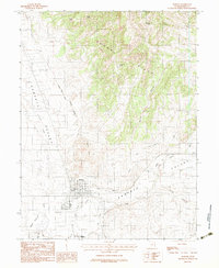
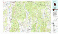 1981 Nephi1981 Print · USGSThe Juab and Sanpete valleys of central Utah are captured here in the early 1980s, during a period of established mountain settlement and rail-based commerce. Researchers can trace the routes of the Union Pacific and visit traditional communities like Nephi, Mount Pleasant, and Scofield.3 unique versions available
 - 1981 Map of Manti
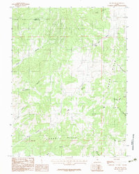
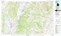 1981 Manti1981 Print · USGSCentral Utah in the early eighties shows a landscape of mountain-fed valleys and high plateau coal mines. Trace the rail lines of the Denver and Rio Grande Western or locate family roots in Gunnison, Orangeville, or Castle Dale.2 unique versions available
 - 1983 Map of Fountain Green North
 1983 Fountain Green North1983 Print · USGSThe transition from the Sanpete Valley into the Uinta National Forest is captured here in the early eighties. Genealogists and local historians can trace the grid of Fountain Green and find landmark water sources like Big Springs, Holman Spring, and Bradley Springs.
 - 1983 Map of Fountain Green South
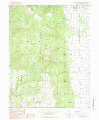 1983 Fountain Green South1983 Print · USGSSanpete County in the early 1980s reveals a rural landscape where mountain canyons meet the valley floor. Researchers can locate the small communities of Freedom and Jerusalem, as well as local landmarks like the Cemetery and Hamburger Lake.2 unique versions available
 - 1983 Map of Moroni
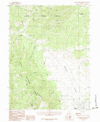
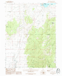
 1983 Moroni1983 Print · USGSSanpete County in the early eighties shows a landscape of precision irrigation and rural industry. Genealogists and historians can trace the streets of Moroni, the path of the San Pitch River, and local landmarks like the Horse Race Track.2 unique versions available
 - 1983 Map of Big Hollow
 1983 Big Hollow1983 Print · USGSSanpete County high-desert terrain is documented here during the early eighties, showing the remote canyonlands along the Juab County line. Researchers can trace vital water sources and landmarks like Whitaker Springs, Pollys Peak, and the winding Big Hollow.2 unique versions available
 - 1985 Map of Scipio North
 1985 Scipio North1985 Print · USGSThe high desert of central Utah comes into focus in the mid-1980s, centered on the settlement of Scipio. Researchers can trace local landmarks like the Cem and the vast Sevier Bridge Reservoir or explore family-named terrain like Dick and Dalton Flat.
 - 1989 Map of Delta
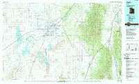 1989 Delta1989 Print · USGSThe Millard County desert in the late eighties reveals a complex irrigation system supporting agricultural life around Delta. Researchers can trace the layout of the Union Pacific Railroad, the historic site of Topaz Camp, and the volcanic features of Pahvant Butte.2 unique versions available
End of results
Showing maps 1-8 of 8
Top cities of Sanpete County
- Ephraim historical maps
- Manti historical maps
- Gunnison historical maps
- Mount Pleasant historical maps
- Moroni historical maps
- Fairview historical maps
See more
Frequently asked questions
- What are the different types of historical maps available for Sanpete County?
- What is the oldest map of Sanpete County?
- Where can I purchase historical maps of Sanpete County for my home or office?
- Where can I download high-res historical maps of Sanpete County?
- Are there historical topographic maps available for Sanpete County?
- Is there historical aerial imagery available for Sanpete County?
- Where are historical maps of Sanpete County sourced from?