1980s Maps of Hurricane, Utah
Explore 5 historic maps of Hurricane from the 1980s. These maps offer a rare glimpse into what life looked like during the 1980s — showing old roads, neighborhoods, homes, and landmarks that have changed or disappeared over time.
Whether you're researching your family's past, planning a metal detecting trip, or studying how Hurricane's landscape evolved across the 1980s, these high-resolution maps are a powerful tool for exploring the history of this region.
- Focus on a specific era: All maps on this page are from the 1980s, giving you a focused view of this time period.
- See what’s changed: Compare century-old streets, trails, and buildings to today's modern landscape using overlays and satellite layers.
- Research with precision: Use these maps for genealogy, historical research, land use analysis, or educational projects.
- View, download, or print: Maps are fully viewable online in high resolution, and can be downloaded or printed for your own records.
Start exploring Hurricane's history through authentic maps from the 1980s. This is your window into the past.
Hurricane, UT maps
(5)- 1980 Map of St. George, 1981 Print
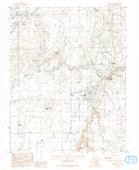
 1980 St. George1981 Print · USGSThe St. George region underwent significant expansion in the early eighties as ranching traditions met new modern development. Researchers can trace the heritage of the Virgin River valley through sites like Grafton, the Apex Mine, and Snow Canyon State Park.2 unique versions available
 - 1986 Map of Hurricane, 1987 Print
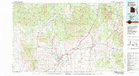
 1986 Hurricane1987 Print · USGSThe Hurricane Valley in the late seventies reveals a landscape of irrigation canals and rugged geological formations. Genealogists and historians can trace the early footprints of Hurricane, La Verkin, and Leeds, while locating landmarks like Pah Tempe Springs and Mollies Nipple.
 - 1986 Map of The Divide, 1987 Print
 1986 The Divide1987 Print · USGSWashington County, Utah, is seen here in the mid-1980s as a high-desert landscape of dramatic escarpments and hidden water sources. Researchers can locate remote mining activity like the Mine Shaft or trace old water infrastructure at Gould Reservoir and Swett Spring.
 - 1986 Map of Washington Dome, 1987 Print
 1986 Washington Dome1987 Print · USGSSouthern Utah in the mid-eighties reveals a landscape of massive geological formations and historical frontier sites. Researchers can locate the Fort Pearce (Site) and trace the route of the Washington Canal past Shinob Kibe and Washington Dome.
 - 1986 Map of Harrisburg Junction, 1987 Print
 1986 Harrisburg Junction1987 Print · USGSSouthwestern Utah in the mid-eighties shows a rugged landscape of high plateaus and river valleys before modern suburban expansion. Genealogists and local historians can trace the Harrisburg (Site) near White Reef or locate old water sources like Berry Springs and Cottonwood Spring.
End of results
Showing maps 1-5 of 5
Top cities near Hurricane
- St. George historical maps
- Washington historical maps
- La Verkin historical maps
- Toquerville historical maps
- Apple Valley historical maps
- Leeds historical maps
See more
Top neighborhoods of Hurricane
Frequently asked questions
- What are the different types of historical maps available for Hurricane?
- What is the oldest map of Hurricane?
- Where can I purchase historical maps of Hurricane for my home or office?
- Where can I download high-res historical maps of Hurricane?
- Are there historical topographic maps available for Hurricane?
- Is there historical aerial imagery available for Hurricane?
- Where are historical maps of Hurricane sourced from?