1960s Maps of Albemarle County, Virginia
Explore 26 historic maps of Albemarle County from the 1960s. These maps offer a rare glimpse into what life looked like during the 1960s — showing old roads, neighborhoods, homes, and landmarks that have changed or disappeared over time.
Whether you're researching your family's past, planning a metal detecting trip, or studying how Albemarle County's landscape evolved across the 1960s, these high-resolution maps are a powerful tool for exploring the history of this region.
- Focus on a specific era: All maps on this page are from the 1960s, giving you a focused view of this time period.
- See what’s changed: Compare century-old streets, trails, and buildings to today's modern landscape using overlays and satellite layers.
- Research with precision: Use these maps for genealogy, historical research, land use analysis, or educational projects.
- View, download, or print: Maps are fully viewable online in high resolution, and can be downloaded or printed for your own records.
Start exploring Albemarle County's history through authentic maps from the 1960s. This is your window into the past.
Albemarle County, VA maps
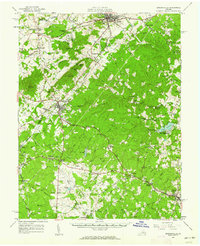
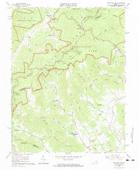
(26)- 1960 Map of Charlottesville And Vicinity
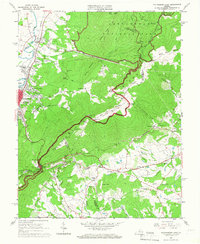
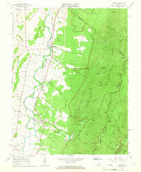
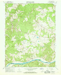
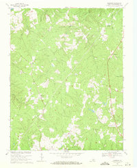
 1960 Charlottesville And Vicinity1960 Print · USGSCharlottesville and the rolling Albemarle County hills are captured here in the mid-twentieth century, centered on the University of Virginia. Genealogists and historians can trace the estates of Monticello and Ash Lawn alongside local landmarks like Riverview Cemetery and Hickory Hill Ch.
 - 1961 Map of Gordonsville, 1962 Print
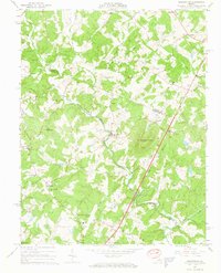
 1961 Gordonsville1962 Print · USGSCentral Virginia in the early sixties remains a landscape of deep historical roots and rail-based commerce. Genealogists and researchers can trace family names through landmarks like Boswells Tavern, the James Madison Grave, and rural sites like Liberty Mills.2 unique versions available
 - 1961 Map of Buckingham, 1963 Print
 1961 Buckingham1963 Print · USGSBuckingham County and the James River corridor are captured here in the early sixties as rural life centered on the river and rail. Genealogists can trace family roots through numerous country landmarks like Liberty Hall Cem, Midway Mills, and St Joy Sch.
 - 1963 Map of Roanoke
 1963 Roanoke1963 Print · USGSCentral Virginia and the Blue Ridge front appear here in the early sixties, caught between their deep railroad roots and new postwar developments. Genealogists and historians can trace the rail lines of the Norfolk and Western through towns like Bedford and Altavista, or locate family landmarks near Smith Mountain Lake.
 - 1964 Map of Barboursville, 1965 Print
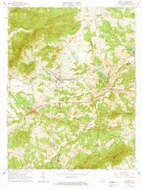
 1964 Barboursville1965 Print · USGSThe Virginia Piedmont near Barboursville comes alive in the mid-1960s, showing a landscape of railroad hamlets and rural mountain ridges. Genealogists can trace family landmarks like Thomas Cem and Knights Chapel or explore the Barbour Ruins near the Southern rail line.4 unique versions available
 - 1964 Map of Charlottesville East, 1965 Print
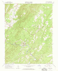
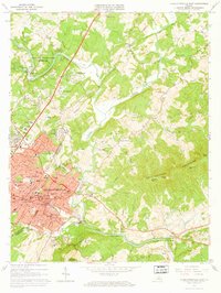 1964 Charlottesville East1965 Print · USGSCharlottesville and the surrounding Albemarle hills are captured here in the mid-sixties, just as the local landscape was being reshaped by new infrastructure. Genealogists and historians can locate Monticello, trace the vanished streets of Vinegar Hill, or find family names at Michie Tavern Cem and Griffin Cem.2 unique versions available
 - 1964 Map of Keswick, 1965 Print
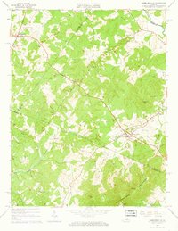
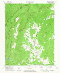
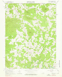
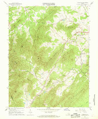
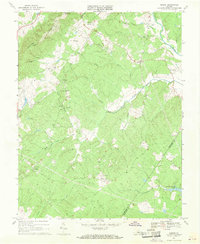
 1964 Keswick1965 Print · USGSAlbemarle County's rural landscape is captured here in the mid-1960s, defined by the rise of the Southwestern Mountains and the busy Chesapeake and Ohio railroad. Researchers can trace family sites and old roads near Walkers Parish Ch, Cismont, and the Shackelford Cem.5 unique versions available
 - 1964 Map of Waynesboro East, 1966 Print
 1964 Waynesboro East1966 Print · USGSThe Blue Ridge crest marks the divide between Augusta and Albemarle counties in the mid-1960s, where engineering and nature meet. Researchers can trace historic mountain passages and early local life through the Blue Ridge Tunnel, Fairfax Hall Jr College, and Critzers Shop.2 unique versions available
 - 1964 Map of Charlottesville West, 1966 Print
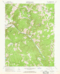
 1964 Charlottesville West1966 Print · USGSAlbemarle County and the western fringe of Charlottesville are captured here in the mid-sixties during a period of significant suburban growth. Genealogists and local historians can trace legacy landmarks like Meriwether Lewis Sch, Mt Calvary Cem, and the historic Farmington estate.2 unique versions available
 - 1965 Map of Browns Cove, 1966 Print
 1965 Browns Cove1966 Print · USGSAlbemarle County in the mid-1960s shows a quiet rural landscape where the Doyles River valley meets the Blue Ridge. Genealogists and historians can locate family sites like Sandridge Cem, Mt Carmel Ch, and a Civil War Gun Emplacement near the gap.3 unique versions available
 - 1965 Map of Mc Gaheysville, 1966 Print
 1965 Mc Gaheysville1966 Print · USGSRockingham County at the edge of the Blue Ridge is captured here during the mid-sixties as the valley's rail lines meet the mountain wilderness. You can trace the Appalachian Trail past Pinefield Shelter or locate local landmarks like Mt Olivet Cem and the Mines near Island Ford.3 unique versions available
 - 1965 Map of Crimora, 1966 Print
 1965 Crimora1966 Print · USGSThe Blue Ridge foothills meet the Shenandoah Valley in the mid-1960s, showing a landscape shaped by mining and mountain travel. Genealogists can locate family sites like Morning Star Cem and Mt Horeb Ch alongside the Crimora Mine.3 unique versions available
 - 1965 Map of Earlysville, 1966 Print
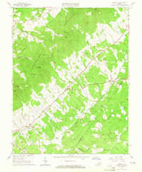
 1965 Earlysville1966 Print · USGSThe Virginia Piedmont comes into sharp focus during the mid-sixties, showing the rural communities of Earlysville and Advance Mills at a moment of transition. Genealogists and local historians can trace family roots through numerous landmarks like Buck Mountain Ch, Broadus Wood Sch, and the scattered Cem markers across the hills.4 unique versions available
 - 1965 Map of Crozet, 1967 Print
 1965 Crozet1967 Print · USGSAlbemarle County is captured in the mid-sixties as the railroad and river networks shaped local growth. Genealogists can trace family landmarks like the Miller School, Rock Gate Cem, and old communities at Yancey Mills and White Hall.
 - 1965 Map of Free Union, 1976 Print
 1965 Free Union1976 Print · USGSAlbemarle and Greene Counties are captured here in the mid-1960s, showing a rural landscape defined by community churches and river confluences. Researchers can locate local landmarks like Prize Hill Ch, the Thompson Cem, and the winding paths of the Mechums River.2 unique versions available
 - 1965 Map of Swift Run Gap, 1983 Print
 1965 Swift Run Gap1983 Print · USGSThe eastern slopes of the Blue Ridge are captured in the mid-1960s, showing a landscape defined by Shenandoah National Park and rural mountain life. Trace family roots and local landmarks from Bacon Hollow to Mission Home, including Mt Olivet Ch and the Dyke Sch.2 unique versions available
 - 1967 Map of Schuyler, 1968 Print
 1967 Schuyler1968 Print · USGSThe Rockfish River valley at the border of Nelson and Albemarle Counties was a hub of industrial and rural life during the late sixties. Genealogists and historians can trace family roots at Rock Springs Ch, locate the old Quarry in Schuyler, or follow the Old Grade Railroad through the foothills.3 unique versions available
 - 1967 Map of Covesville, 1968 Print
 1967 Covesville1968 Print · USGSAlbemarle County orchards and mountain gaps define this late-sixties landscape as it transitioned toward the modern era. Researchers can trace family history through the Red Hill Sch and numerous cemeteries like Wild Rose Cem and Rising Sun Ch Cem.3 unique versions available
 - 1967 Map of Boyd Tavern, 1968 Print
 1967 Boyd Tavern1968 Print · USGSFluvanna County's rural landscape is captured here in the late sixties as the Rivanna River snakes through a region of old mills and crossroads. Genealogists can trace family footprints near historic sites like Boyd Tavern, Union Mills, and Haden Chapel.4 unique versions available
 - 1967 Map of Alberene, 1968 Print
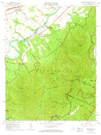
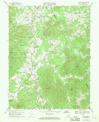
 1967 Alberene1968 Print · USGSAlbemarle County's mountain ridges and river valleys are captured here during the late sixties, showcasing a landscape of rural settlements and emerging suburbs. Genealogists can trace family footprints through numerous small cemeteries, local churches like Grace Ch, and landmarks such as Powell Corner and Red Hill.2 unique versions available
 - 1967 Map of Esmont, 1968 Print
 1967 Esmont1968 Print · USGSAlbemarle County's Piedmont landscape is captured here in the late sixties, showing the vital river-and-rail corridor along the southern border. Genealogists and local historians can trace family locations near Esmont, Keene, and Scottsville, or find local landmarks like Yancy Sch and Dawson Mill.3 unique versions available
 - 1967 Map of Simeon, 1969 Print
 1967 Simeon1969 Print · USGSAlbemarle County is shown in the mid-sixties, capturing the rural character of the Piedmont hills before modern suburban expansion. Genealogists and historians can trace the estates at Ash Lawn and Blenheim alongside local landmarks like Middle Oak Ch.2 unique versions available
 - 1967 Map of Scottsville, 1969 Print
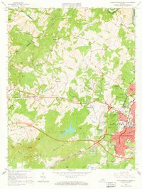
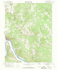 1967 Scottsville1969 Print · USGSThe James River region at the end of the 1960s reveals a landscape defined by sharp river bends and industrial heritage. Genealogists and historians can trace family locations near Scottsville, Jefferson Mill, and rural landmarks like Fox Memorial Ch.2 unique versions available
 - 1967 Map of Greenfield, 1970 Print
 1967 Greenfield1970 Print · USGSThe Rockfish River valley in Nelson and Albemarle counties was a network of small family settlements and country parishes in the late sixties. Genealogists and historians can trace local roots at Hebron Ch, Nellysford, and Durrett Town, or locate old landmarks like Stockton Mill Creek and Tool Gap.3 unique versions available
 - 1968 Map of Glenmore, 1971 Print
 1968 Glenmore1971 Print · USGSBuckingham County's rural heartland is captured here in the late sixties, showing a landscape of small farming communities and historic parish churches. Genealogists can trace family footprints near Glenmore, Axtell, and Salem Ch, or locate the site of Paynes Millpond.2 unique versions available
Showing maps 1-25 of 26
Top cities of Albemarle County
- Hollymead historical maps
- University of Virginia historical maps
- Crozet historical maps
- Pantops historical maps
- Rivanna historical maps
- Rio historical maps
See more
Frequently asked questions
- What are the different types of historical maps available for Albemarle County?
- What is the oldest map of Albemarle County?
- Where can I purchase historical maps of Albemarle County for my home or office?
- Where can I download high-res historical maps of Albemarle County?
- Are there historical topographic maps available for Albemarle County?
- Is there historical aerial imagery available for Albemarle County?
- Where are historical maps of Albemarle County sourced from?