Old Maps of Doylesville, Virginia for Hiking & Exploration
Hike through history with 14 historic maps of Doylesville. Explore old trails, ghost towns, and forgotten backroads — perfect for outdoor adventurers and local explorers.
- Rediscover forgotten places: Map out old mining camps, roads, and footpaths that no longer exist on modern maps.
- Layer with modern tools: Combine with LiDAR or satellite views to plan hikes through historical terrain.
- Made for exploration: Popular among hikers, overlanders, and local history lovers.
Use these maps to find adventure and explore the hidden past of Doylesville.
Doylesville, VA maps
(14)- 1892 Map of Harrisonburg, 1901 Print
 1892 Harrisonburg1901 Print · USGSThe Shenandoah Valley during the 1890s reveals a landscape of thriving springs, mills, and emerging industry across Rockingham and Albemarle counties. Genealogists can trace family locations through sites like Meyerhoffer's Store, the Crimora Mine, and the University of Virginia Observatory.6 unique versions available
 - 1931 Map of University
 1931 University1931 Print · USGSAlbemarle County is shown here during the late Prohibition era, when the university and the railroad defined the local economy. Genealogists can trace family names through landmarks like the Miller School, Whitehall, and Mt Plains Ch.2 unique versions available
 - 1935 Map of University, 1962 Print
 1935 University1962 Print · USGSAlbemarle County is captured here in the mid-thirties as the new national park and Skyline Drive begin to reshape the Blue Ridge peaks. Genealogists can trace family names across dozens of rural institutions, from the Miller School to Meriwether Lewis Sch and Hillsboro.
 - 1949 Map of Charlottesville
 1949 Charlottesville1949 Print · USGSThe Shenandoah Valley and Blue Ridge appear in the late 1940s as a thriving corridor of rail and river commerce. Researchers can trace the mid-century footprints of Harrisonburg, Staunton, and Culpeper alongside the historic routes of the Southern Railway.2 unique versions available
 - 1956 Map of Charlottesville, 1966 Print
 1956 Charlottesville1966 Print · USGSThe Shenandoah Valley and Blue Ridge are captured in detail during the mid-1960s as the modern interstate system began to emerge. Genealogists and historians can trace rail-connected hubs like Waynesboro or follow the river paths of the Rapidan River and Rivanna River.4 unique versions available
 - 1965 Map of Browns Cove, 1966 Print
 1965 Browns Cove1966 Print · USGSAlbemarle County in the mid-1960s shows a quiet rural landscape where the Doyles River valley meets the Blue Ridge. Genealogists and historians can locate family sites like Sandridge Cem, Mt Carmel Ch, and a Civil War Gun Emplacement near the gap.3 unique versions available
 - 1977 Map of Browns Cove, 1982 Print
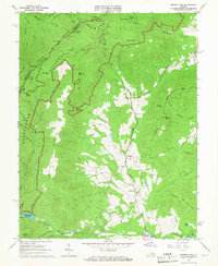
 1977 Browns Cove1982 Print · USGSThe foothills of the Blue Ridge Mountains appear in the late 1970s as a mix of high-altitude wilderness and valley farmsteads. Trace early settlements at Browns Cove and Doylesville alongside the winding path of Skyline Drive.
 - 1986 Map of Charlottesville
 1986 Charlottesville1986 Print · USGSCentral Virginia in the mid-eighties shows a landscape balanced between the growing city centers of the Piedmont and the protected ridges of the Blue Ridge. Trace the historic rail lines of the Chesapeake and Ohio Railway or locate local landmarks like Monticello Mountain and Bridgewater College.3 unique versions available
 - 1997 Map of Browns Cove, 1999 Print
 1997 Browns Cove1999 Print · USGSThe Albemarle and Rockingham county line meets the high ridges of the Blue Ridge in the late nineties, where mountain wilderness meets Piedmont valleys. Genealogists and hikers can trace the Appalachian Trail past Blackrock Shelter or locate rural landmarks like Browns Cove Ch and Sandridge Cem.
 - 2010 Map of Browns Cove, 2010 Print
 2010 Browns Cove2010 Print · USGSCovers Doylesville, including Mountfair, Albemarle County, and other nearby areas
 - 2013 Map of Browns Cove, 2013 Print
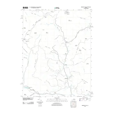
 2013 Browns Cove2013 Print · USGSCovers Doylesville, including Mountfair, Albemarle County, and other nearby areas
 - 2016 Map of Browns Cove, 2016 Print
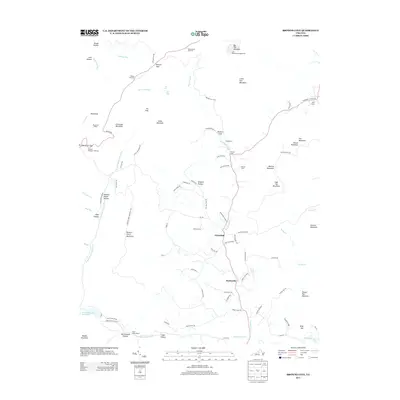
 2016 Browns Cove2016 Print · USGSCovers Doylesville, including Mountfair, Albemarle County, and other nearby areas
 - 2019 Map of Browns Cove, 2019 Print
 2019 Browns Cove2019 Print · USGSCovers Doylesville, including Mountfair, Albemarle County, and other nearby areas
 - 2022 Map of Browns Cove, 2022 Print
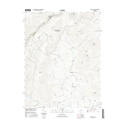
 2022 Browns Cove2022 Print · USGSAlbemarle County's Blue Ridge foothills are captured here in the early twenty-first century as they transition from wilderness to historic farmsteads. Researchers can locate family cemeteries like Sandridge Cem or trace the rural routes connecting Mountfair and Deep Rock Farm.
End of results
Showing maps 1-14 of 14
Top cities near Doylesville
- Charlottesville historical maps
- Waynesboro historical maps
- Hollymead historical maps
- University of Virginia historical maps
- Crozet historical maps
- Pantops historical maps
See more
Frequently asked questions
- What are the different types of historical maps available for Doylesville?
- What is the oldest map of Doylesville?
- Where can I purchase historical maps of Doylesville for my home or office?
- Where can I download high-res historical maps of Doylesville?
- Are there historical topographic maps available for Doylesville?
- Is there historical aerial imagery available for Doylesville?
- Where are historical maps of Doylesville sourced from?