1930s Maps of King William County, Virginia
Explore 2 historic maps of King William County from the 1930s. These maps offer a rare glimpse into what life looked like during the 1930s — showing old roads, neighborhoods, homes, and landmarks that have changed or disappeared over time.
Whether you're researching your family's past, planning a metal detecting trip, or studying how King William County's landscape evolved across the 1930s, these high-resolution maps are a powerful tool for exploring the history of this region.
- Focus on a specific era: All maps on this page are from the 1930s, giving you a focused view of this time period.
- See what’s changed: Compare century-old streets, trails, and buildings to today's modern landscape using overlays and satellite layers.
- Research with precision: Use these maps for genealogy, historical research, land use analysis, or educational projects.
- View, download, or print: Maps are fully viewable online in high resolution, and can be downloaded or printed for your own records.
Start exploring King William County's history through authentic maps from the 1930s. This is your window into the past.
King William County, VA maps
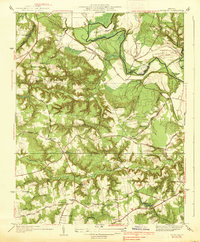
(2)- 1933 Map of Aylett
 1933 Aylett1933 Print · USGSCoastal Plain Virginia during the 1930s shows a landscape of river-based commerce and tight-knit farming communities. Genealogists and historians can trace family locations near Aylett, locate the Millfork School, or find old mills like Dublin Mill.2 unique versions available
 - 1938 Map of Studley
 1938 Studley1938 Print · USGSHanover County's rural character is captured in the mid-1930s before the expansion of the Richmond suburbs. Genealogists can trace family landmarks and community hubs like Bethesda Ch, Studley, and the Pole Green Sch along the historic Pamunkey River corridor.3 unique versions available
End of results
Showing maps 1-2 of 2
Top cities of King William County
Frequently asked questions
- What are the different types of historical maps available for King William County?
- What is the oldest map of King William County?
- Where can I purchase historical maps of King William County for my home or office?
- Where can I download high-res historical maps of King William County?
- Are there historical topographic maps available for King William County?
- Is there historical aerial imagery available for King William County?
- Where are historical maps of King William County sourced from?