1970s Maps of King William County, Virginia
Explore 6 historic maps of King William County from the 1970s. These maps offer a rare glimpse into what life looked like during the 1970s — showing old roads, neighborhoods, homes, and landmarks that have changed or disappeared over time.
Whether you're researching your family's past, planning a metal detecting trip, or studying how King William County's landscape evolved across the 1970s, these high-resolution maps are a powerful tool for exploring the history of this region.
- Focus on a specific era: All maps on this page are from the 1970s, giving you a focused view of this time period.
- See what’s changed: Compare century-old streets, trails, and buildings to today's modern landscape using overlays and satellite layers.
- Research with precision: Use these maps for genealogy, historical research, land use analysis, or educational projects.
- View, download, or print: Maps are fully viewable online in high resolution, and can be downloaded or printed for your own records.
Start exploring King William County's history through authentic maps from the 1970s. This is your window into the past.
King William County, VA maps
(6)- 1970 Map of Truhart, 1984 Print
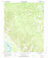 1970 Truhart1984 Print · USGSKing and Queen County in the early seventies remains a landscape of deep swamps and riverfront landings. Local historians can trace family roots through the Exol Cem, old schools, and country churches like Second Mount Olive Ch and Lower King and Queen Ch.2 unique versions available
 - 1973 Map of Richmond, 1974 Print
 1973 Richmond1974 Print · USGSThe Virginia Tidewater and Piedmont come alive in the early seventies, showcasing a region defined by its great rivers and massive military installations. Researchers can trace the mid-century growth of Richmond or locate family sites near Amelia Court House and Highland Springs.2 unique versions available
 - 1973 Map of West Point, 1977 Print
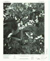
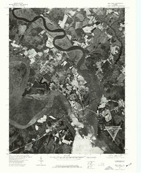 1973 West Point1977 Print · USGSCoastal Virginia's river-driven geography is clearly visible in the early 1970s at the meeting of three major waterways. Researchers can trace the town of West Point and its industrial layout at the head of the York River and the tidal bends of the Mattaponi River.
 - 1973 Map of New Kent, 1977 Print
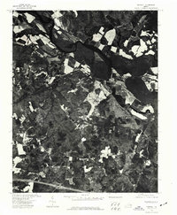
 1973 New Kent1977 Print · USGSCoastal Virginia's rural landscape is captured in the early 1970s, showcasing the winding Pamunkey River and its surrounding wetlands. Genealogists and local historians can trace the early layout of the New Kent area and examine the relationship between agricultural fields and the river's edge.
 - 1974 Map of Tunstall, 1977 Print
 1974 Tunstall1977 Print · USGSNew Kent County is seen in the mid-1970s through this aerial-imagery survey of the Tunstall area. Genealogists and researchers can trace the physical layout of the village of Tunstall and the surrounding farms as they existed before modern development.
 - 1974 Map of Studley, 1977 Print
 1974 Studley1977 Print · USGSMid-century Hanover County farmland and forest are preserved in detail in this orthophotograph produced during the 1970s. Trace the meandering path of the Pamunkey River and examine the clear-cut boundaries of historical field patterns and woodland tracts.
End of results
Showing maps 1-6 of 6
Top cities of King William County
Frequently asked questions
- What are the different types of historical maps available for King William County?
- What is the oldest map of King William County?
- Where can I purchase historical maps of King William County for my home or office?
- Where can I download high-res historical maps of King William County?
- Are there historical topographic maps available for King William County?
- Is there historical aerial imagery available for King William County?
- Where are historical maps of King William County sourced from?