1980s Maps of King William County, Virginia
Explore 2 historic maps of King William County from the 1980s. These maps offer a rare glimpse into what life looked like during the 1980s — showing old roads, neighborhoods, homes, and landmarks that have changed or disappeared over time.
Whether you're researching your family's past, planning a metal detecting trip, or studying how King William County's landscape evolved across the 1980s, these high-resolution maps are a powerful tool for exploring the history of this region.
- Focus on a specific era: All maps on this page are from the 1980s, giving you a focused view of this time period.
- See what’s changed: Compare century-old streets, trails, and buildings to today's modern landscape using overlays and satellite layers.
- Research with precision: Use these maps for genealogy, historical research, land use analysis, or educational projects.
- View, download, or print: Maps are fully viewable online in high resolution, and can be downloaded or printed for your own records.
Start exploring King William County's history through authentic maps from the 1980s. This is your window into the past.
King William County, VA maps
(2)- 1984 Map of Tappahannock
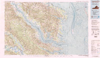 1984 Tappahannock1984 Print · USGSThe Northern Neck and Middle Peninsula of Virginia are captured in detail during the mid-1980s, showcasing the region's deep-rooted maritime and agricultural identity. Genealogists and local historians can trace family locations across the intricate shorelines of the Rappahannock River and settlements like Kilmarnock, Heathsville, and Urbanna.3 unique versions available
 - 1984 Map of Richmond, 1986 Print
 1984 Richmond1986 Print · USGSCentral Virginia during the mid-eighties shows a landscape of rapid suburban expansion centered on the state capital and its historic riverfront. Genealogists and historians can trace institutional sites like Randolph-Macon College, the grounds of Fort Lee, and small community landmarks like Hebron Ch.3 unique versions available
End of results
Showing maps 1-2 of 2
Top cities of King William County
Frequently asked questions
- What are the different types of historical maps available for King William County?
- What is the oldest map of King William County?
- Where can I purchase historical maps of King William County for my home or office?
- Where can I download high-res historical maps of King William County?
- Are there historical topographic maps available for King William County?
- Is there historical aerial imagery available for King William County?
- Where are historical maps of King William County sourced from?