1950s Maps of King William County, Virginia
Explore 7 historic maps of King William County from the 1950s. These maps offer a rare glimpse into what life looked like during the 1950s — showing old roads, neighborhoods, homes, and landmarks that have changed or disappeared over time.
Whether you're researching your family's past, planning a metal detecting trip, or studying how King William County's landscape evolved across the 1950s, these high-resolution maps are a powerful tool for exploring the history of this region.
- Focus on a specific era: All maps on this page are from the 1950s, giving you a focused view of this time period.
- See what’s changed: Compare century-old streets, trails, and buildings to today's modern landscape using overlays and satellite layers.
- Research with precision: Use these maps for genealogy, historical research, land use analysis, or educational projects.
- View, download, or print: Maps are fully viewable online in high resolution, and can be downloaded or printed for your own records.
Start exploring King William County's history through authentic maps from the 1950s. This is your window into the past.
King William County, VA maps
(7)- 1950 Map of West Point
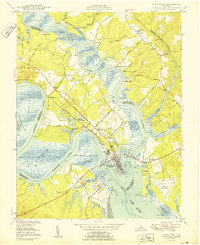 1950 West Point1950 Print · USGSCoastal Virginia at the turn of the decade centers on the confluence of the Mattaponi and Pamunkey. Researchers can trace family sites at Chelsea, locate historic burials at Sunny Slope Cem, and follow the SOUTHERN rail lines into the heart of West Point.2 unique versions available
 - 1950 Map of Old Church
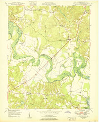 1950 Old Church1950 Print · USGSThe Pamunkey River basin in the early postwar era reveals a landscape of tidal swamps and scattered crossroads communities. Genealogists and historians can trace the foundations of the area at Old Church, Appersons Store, and historic landings like Carters Landing.2 unique versions available
 - 1951 Map of Sparta
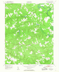
 1951 Sparta1951 Print · USGSCoastal Virginia in the early fifties shows a landscape of river-bottom swamps and small farm settlements. Genealogists and local historians can trace family locations near Jerusalem Sch, Broaddus Mill Pond, and the rural crossroads of Sparta.2 unique versions available
 - 1951 Map of Beulahville
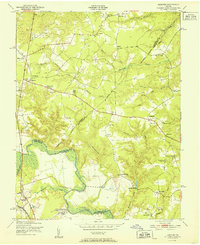
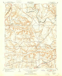
 1951 Beulahville1951 Print · USGSKing William County in the early fifties shows a rural Tidewater landscape shaped by its winding creeks and small crossroads. Researchers can trace historic mill sites like Herring Creek Mill and local centers such as Pollards Corner and Beulahville.
 - 1951 Map of Hanover
 1951 Hanover1951 Print · USGSMid-century rural life in Hanover and King William counties centered on the river and the rail line. Researchers can trace family-named landmarks and institutions like Mangohick, the Virginia Industrial School for Boys, and Gravatts Mill.
 - 1951 Map of Studley
 1951 Studley1951 Print · USGSHanover County at mid-century reveals a rural landscape defined by the winding Pamunkey River and its many creek systems. Researchers can trace family roots through historic crossroads like Rural Point and Hundleys Corner, or locate institutions like Battlefield Park High Sch and New Bethesda Ch.
 - 1959 Map of Richmond
 1959 Richmond1959 Print · USGSMid-century Virginia is captured here at its most vital rail and river junctions, from the capital city to the Chesapeake Bay. Genealogists and historians can trace the development of colonial settlements like Williamsburg and military landmarks including Fort Monroe and Camp Lee.
End of results
Showing maps 1-7 of 7
Top cities of King William County
Frequently asked questions
- What are the different types of historical maps available for King William County?
- What is the oldest map of King William County?
- Where can I purchase historical maps of King William County for my home or office?
- Where can I download high-res historical maps of King William County?
- Are there historical topographic maps available for King William County?
- Is there historical aerial imagery available for King William County?
- Where are historical maps of King William County sourced from?