Old Maps of Loudoun County, Virginia for Hiking & Exploration
Hike through history with 213 historic maps of Loudoun County. Explore old trails, ghost towns, and forgotten backroads — perfect for outdoor adventurers and local explorers.
- Rediscover forgotten places: Map out old mining camps, roads, and footpaths that no longer exist on modern maps.
- Layer with modern tools: Combine with LiDAR or satellite views to plan hikes through historical terrain.
- Made for exploration: Popular among hikers, overlanders, and local history lovers.
Use these maps to find adventure and explore the hidden past of Loudoun County.
Loudoun County, VA maps
(213)- 1884 Map of Harpers Ferry
 1884 Harpers Ferry1884 Print · USGSThe confluence of the Potomac and Shenandoah rivers is captured in the mid-1880s, documenting a landscape of strategic gaps and vital transit corridors. Researchers can trace the path of the Chesapeake and Ohio Canal and locate historic river crossings like Conrad Ferry and Castleman Ferry.
 - 1890 Map of Mt. Vernon
 1890 Mt. Vernon1890 Print · USGSNorthern Virginia and the capital region appear here in the decade before the turn of the century, showing a landscape of river estates and rail-connected villages. Researchers can trace early property sites and historic river landings from Mt. Vernon to Occoquan and Falls Church.
 - 1891 Map of Harpers Ferry
 1891 Harpers Ferry1891 Print · USGSThe tri-state borderlands of the Potomac and Shenandoah valleys were a vital hub of transport and trade in the late 1800s. Researchers can trace historic river crossings like Castlemans Ferry, follow the route of the Chesapeake and Ohio Canal, or locate family-named settlements like Oatlands and Taylorstown.
 - 1891 Map of Mt. Vernon
 1891 Mt. Vernon1891 Print · USGSNorthern Virginia and the D.C. area appear here in the late nineteenth century, as the rail-and-river economy connected rural counties to the capital. Researchers can trace ancestral roots through dozens of local landmarks, including Arlington National Cemetery, the Fox Ferry, and historic towns like Occoquan and Vienna.
 - 1893 Map of Frederick
 1893 Frederick1893 Print · USGSMaryland's Piedmont region at the end of the nineteenth century reveals a landscape defined by the Potomac River and the rise of rail transit. Researchers can trace the path of the Chesapeake and Ohio Canal or locate local hubs like Poolesville and Buckeystown.
 - 1893 Map of Harpers Ferry, 1898 Print
 1893 Harpers Ferry1898 Print · USGSThe tri-state region of the Potomac and Shenandoah valleys is captured here in the late nineteenth century, showing a landscape defined by water and rail. Trace the historic Chesapeake and Ohio Canal or locate local landmarks like Snyder Mills and Harpers Ferry.7 unique versions available
 - 1894 Map of Warrenton
 1894 Warrenton1894 Print · USGSVirginia's northern Piedmont and mountain gaps are mapped here in the late nineteenth century as the rail-and-river economy flourished. Genealogists can trace family names and small crossroads from Warrenton and Brentsville to White Sulphur Springs.9 unique versions available
 - 1894 Map of Frederick
 1894 Frederick1894 Print · USGSMaryland's Piedmont region in the late nineteenth century was a complex network of river crossings and railway junctions. Researchers can trace the path of the Baltimore & Ohio R. R. past Sugar Loaf Mtn. and locate historic river sites like Nolands Ferry.5 unique versions available
 - 1894 Map of Mt. Vernon, 1904 Print
 1894 Mt. Vernon1904 Print · USGSThe Potomac River valley south of the capital was still largely a landscape of crossroads and rail depots in the late nineteenth century. Genealogists can trace the rural reaches of Fairfax through landmarks like Arlington National Cemetery, Mt. Vernon, and Tyson Cross Roads.6 unique versions available
 - 1897 Map of Mt. Vernon
 1897 Mt. Vernon1897 Print · USGSNorthern Virginia and the Potomac River appear in the late nineteenth century as a landscape of rural crossroads and strategic fortifications. Trace the early footprints of Vienna, Herndon, and Manassas along the path of the Southern R. R.2 unique versions available
 - 1908 Map of Middletown
 1908 Middletown1908 Print · USGSThe Potomac River valley in the early twentieth century shows a landscape defined by the convergence of major rail lines and the historic Chesapeake and Ohio Canal. Genealogists and historians can trace the foundations of Eakles Mills, Burkittsville, and Washington Junction.
 - 1908 Map of Seneca
 1908 Seneca1908 Print · USGSThe Potomac River valley at the turn of the century shows a vital landscape of canal commerce and emerging rail lines. Genealogists and historians can trace family-named sites across the Maryland-Virginia border, from Poolesville to river crossings at Whites Ferry and Edwards Ferry.7 unique versions available
 - 1908 Map of Ijamsville, 1921 Print
 1908 Ijamsville1921 Print · USGSFrederick and its surrounding valley are captured here just after the turn of the century, showing a landscape defined by historic turnpikes and the winding Monocacy River. Genealogists and historians can trace defunct schoolhouses, early turnpike toll gates like Fountain Rock T.G., and family landmarks near Sugarloaf Mtn.
 - 1909 Map of Ijamsville
 1909 Ijamsville1909 Print · USGSFrederick County and parts of Montgomery County are documented here during an era of significant rail and turnpike expansion. Genealogists and historians can locate early post offices and stations such as Araby P O, Ijamsville, and the Almshouse near Frederick.9 unique versions available
 - 1910 Map of Antietam
 1910 Antietam1910 Print · USGSMaryland's borderlands and the Potomac River valley are captured here in the early twentieth century. Genealogists can locate family landmarks like Garretts Mill, trace the Chesapeake and Ohio Canal, or find historic sites including Dunkard Church.6 unique versions available
 - 1914 Map of Martinsburg
 1914 Martinsburg1914 Print · USGSThe eastern panhandle of West Virginia comes alive in this survey, showing a landscape defined by the Potomac River and burgeoning rail hubs. Genealogists can trace family footprints through dozens of schools and churches, from Shepherdstown to the Snyder Hill Riverside School and John Browns Cave.3 unique versions available
 - 1915 Map of Fairfax
 1915 Fairfax1915 Print · USGSNorthern Virginia in the early twentieth century appears as a collection of quiet rail towns and farmsteads. Trace the old routes of the Southern RR and find family-named landmarks like Sideburn, Balls Ford, and Bear School.4 unique versions available
 - 1916 Map of Martinsburg
 1916 Martinsburg1916 Print · USGSThe Eastern Panhandle of West Virginia comes to life in the years before the Great War, showing a bustling hub of rail activity and river commerce. Genealogists and historians can trace family roots through schoolhouses like Sutton School and old settlements such as Middleway and Summit Point.4 unique versions available
 - 1916 Map of Berryville, 1920 Print
 1916 Berryville1920 Print · USGSThe lower Shenandoah Valley at the onset of the Great War was a landscape defined by its river ferries and growing rail lines. Genealogists and historians can trace the foundations of local life through rural landmarks like Mountain Mission, Furnace School, and the river crossing at Shannondale Ferry.2 unique versions available
 - 1933 Map of Middleburg
 1933 Middleburg1933 Print · USGSNorthern Virginia is captured here in the years following the Great War, showing a landscape defined by its ridges and historical milestones. Genealogists and historians can locate family landmarks like the Henry House, Beverly Mill, and rural centers such as Hickory Grove.
 - 1939 Map of Berryville
 1939 Berryville1939 Print · USGSNorthern Virginia and the West Virginia borderlands appear here in the late thirties as a landscape of river fords and mountain gaps. Genealogists can trace family names at Locke Mill, Shepherd Ford, and the Mt Olive Cem.
 - 1942 Map of Frederick
 1942 Frederick1942 Print · USGSMid-century Maryland's central corridor is centered on Frederick as it appeared before the modern interstate system. Researchers can trace the routes of the B & O Canal, locate the Montevue Almshouse, and see the intersection of the Northern Central RR with early turnpikes.
 - 1943 Map of Arcola, 1957 Print
 1943 Arcola1957 Print · USGSNorthern Virginia remains a landscape of quiet crossroads and family farms during the mid-1940s. Genealogists can trace rural life through landmarks like Watson Sch, Conklin Ch, and the small settlement of Lenah along the Lee-Jackson Memorial Highway.3 unique versions available
 - 1943 Map of Bluemont, 1960 Print
 1943 Bluemont1960 Print · USGSLoudoun County’s rural heritage is preserved here in the 1940s, showing the ridge-and-valley landscape before modern development. Genealogists can trace family roots through settlements like Unison and Willisville, and landmarks like Ebenezer Ch.
 - 1943 Map of Ashby Gap, 1961 Print
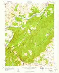 1943 Ashby Gap1961 Print · USGSThe Blue Ridge mountains and Shenandoah Valley meet in the early 1940s, showing a landscape of high ridges and winding river bends. Trace the path of the Appalachian Trail past Mt Weather or locate rural landmarks like Mt Carmel Ch and Millwood.
Showing maps 1-25 of 213
Top cities of Loudoun County
- Leesburg historical maps
- Ashburn historical maps
- South Riding historical maps
- Sterling historical maps
- Brambleton historical maps
- Stone Ridge historical maps
See more
Frequently asked questions
- What are the different types of historical maps available for Loudoun County?
- What is the oldest map of Loudoun County?
- Where can I purchase historical maps of Loudoun County for my home or office?
- Where can I download high-res historical maps of Loudoun County?
- Are there historical topographic maps available for Loudoun County?
- Is there historical aerial imagery available for Loudoun County?
- Where are historical maps of Loudoun County sourced from?