1920s Maps of Shenandoah County, Virginia
Explore 7 historic maps of Shenandoah County from the 1920s. These maps offer a rare glimpse into what life looked like during the 1920s — showing old roads, neighborhoods, homes, and landmarks that have changed or disappeared over time.
Whether you're researching your family's past, planning a metal detecting trip, or studying how Shenandoah County's landscape evolved across the 1920s, these high-resolution maps are a powerful tool for exploring the history of this region.
- Focus on a specific era: All maps on this page are from the 1920s, giving you a focused view of this time period.
- See what’s changed: Compare century-old streets, trails, and buildings to today's modern landscape using overlays and satellite layers.
- Research with precision: Use these maps for genealogy, historical research, land use analysis, or educational projects.
- View, download, or print: Maps are fully viewable online in high resolution, and can be downloaded or printed for your own records.
Start exploring Shenandoah County's history through authentic maps from the 1920s. This is your window into the past.
Shenandoah County, VA maps
(7)- 1921 Map of Orkney Springs
 1921 Orkney Springs1921 Print · USGSHardy County life in the early 1920s was centered in the valley between the high ridges of Shenandoah and South Fork mountains. Genealogists can trace family footprints through a dense network of rural schools and churches, including Jenkins Chapel, Mathias, and the Lumber RR.2 unique versions available
 - 1922 Map of Wardensville
 1922 Wardensville1922 Print · USGSThe Hardy County highlands in the early twenties show a landscape of isolated hollows and mountain railroads. Genealogists can locate family homesteads near numerous country schools like Sugar Grove School and tracks of the Winchester and Western.
 - 1923 Map of Middletown
 1923 Middletown1923 Print · USGSThe West Virginia and Virginia borderlands were a patchwork of mountain farms and river crossings in the early 1920s. Genealogists can trace family names through landmarks like Hooks Mills, Capon Springs, and the Christian Church.
 - 1923 Map of Orkney Springs
 1923 Orkney Springs1923 Print · USGSHardy County, West Virginia, is shown in the early twenties as a landscape of rural schoolhouses and mountain churches tucked between high ridges. Genealogists can locate specific family-named landmarks like Halterman School, Jenkins Chapel, and the Lumber RR line.2 unique versions available
 - 1923 Map of Edinburg
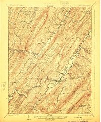
 1923 Edinburg1923 Print · USGSThe Virginia and West Virginia borderlands appear in the early twenties as a landscape of isolated mountain schools and forest lookouts. Genealogists can trace family footprints around the Heishman School and Mt Vernon Church or locate early settlements at Rockland and Perry.5 unique versions available
 - 1924 Map of Wardensville
 1924 Wardensville1924 Print · USGSWardensville and the surrounding mountains of Hardy County are shown here during the early twenties. Genealogists can trace family names through landmarks like Heishman School, Rio, and Crest Hill Church along the river valleys.2 unique versions available
 - 1929 Map of Stony Man
 1929 Stony Man1929 Print · USGSBlue Ridge mountain life and the early development of Shenandoah National Park are captured here just as the park boundary was being established. Genealogists and hikers can trace old mountain routes to the President Hoover Community Sch, locate St Luke Episcopal Mission, or find early trail markers at Sexton Shelter.2 unique versions available
End of results
Showing maps 1-7 of 7
Top cities of Shenandoah County
- Strasburg historical maps
- Woodstock historical maps
- New Market historical maps
- Mount Jackson historical maps
- Basye historical maps
- Edinburg historical maps
See more
Frequently asked questions
- What are the different types of historical maps available for Shenandoah County?
- What is the oldest map of Shenandoah County?
- Where can I purchase historical maps of Shenandoah County for my home or office?
- Where can I download high-res historical maps of Shenandoah County?
- Are there historical topographic maps available for Shenandoah County?
- Is there historical aerial imagery available for Shenandoah County?
- Where are historical maps of Shenandoah County sourced from?