1950s Maps of Shenandoah County, Virginia
Explore 7 historic maps of Shenandoah County from the 1950s. These maps offer a rare glimpse into what life looked like during the 1950s — showing old roads, neighborhoods, homes, and landmarks that have changed or disappeared over time.
Whether you're researching your family's past, planning a metal detecting trip, or studying how Shenandoah County's landscape evolved across the 1950s, these high-resolution maps are a powerful tool for exploring the history of this region.
- Focus on a specific era: All maps on this page are from the 1950s, giving you a focused view of this time period.
- See what’s changed: Compare century-old streets, trails, and buildings to today's modern landscape using overlays and satellite layers.
- Research with precision: Use these maps for genealogy, historical research, land use analysis, or educational projects.
- View, download, or print: Maps are fully viewable online in high resolution, and can be downloaded or printed for your own records.
Start exploring Shenandoah County's history through authentic maps from the 1950s. This is your window into the past.
Shenandoah County, VA maps
(7)- 1950 Map of Broadway
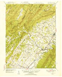
 1950 Broadway1950 Print · USGSRockingham County at the mid-century mark shows a landscape defined by the Southern railroad and the North Fork River. Genealogists and historians can trace family locations near Singers Glen, Lacey Spring, and dozens of landmarks like Trissel Ch.
 - 1950 Map of Strasburg
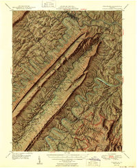 1950 Strasburg1950 Print · USGSThe northern Shenandoah Valley is shown just after the war, defined by the winding forks of the river and the massive ridges of Massanutten Mountain. Genealogists and historians can trace family sites at Mt Hebron Cemetery, Goode Mill, and the mountain-bound community of Seven Fountains.2 unique versions available
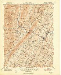
 - 1951 Map of Edinburg
 1951 Edinburg1951 Print · USGSShenandoah County is shown here at the start of the 1950s, where the river valley and rail lines shaped a landscape of small towns and industrial history. Genealogists and historians can trace family locations through numerous rural sites like Lantz Mills, Sugar Hill Cem, and Pleasant Grove Sch.
 - 1952 Map of Cumberland
 1952 Cumberland1952 Print · USGSThe Potomac Highlands and the Shenandoah Valley are revealed in this early 1950s survey of the Appalachian interior. Researchers can trace the river-and-rail corridors connecting Cumberland, Winchester, and the recreational waters of Deep Creek Lake.
 - 1956 Map of Cumberland, 1966 Print
 1956 Cumberland1966 Print · USGSThe tri-state Highlands in the mid-1950s show a landscape shaped by coal, timber, and the massive presence of the Baltimore & Ohio RR. Researchers can trace the industrial corridor from Cumberland through the Allegheny Mountains to mountain retreats like Deep Creek Lake.6 unique versions available
 - 1956 Map of Charlottesville, 1966 Print
 1956 Charlottesville1966 Print · USGSThe Shenandoah Valley and Blue Ridge are captured in detail during the mid-1960s as the modern interstate system began to emerge. Genealogists and historians can trace rail-connected hubs like Waynesboro or follow the river paths of the Rapidan River and Rivanna River.4 unique versions available
 - 1957 Map of Cumberland
 1957 Cumberland1957 Print · USGSThe Potomac River valley and the ridges of the Allegheny Front define this mid-century landscape at the intersection of Maryland, West Virginia, and Pennsylvania. Trace the steam-era rail lines of the Baltimore and Ohio RR or locate rural landmarks like St Stephens Church and Stony River Dam.
End of results
Showing maps 1-7 of 7
Top cities of Shenandoah County
- Strasburg historical maps
- Woodstock historical maps
- New Market historical maps
- Mount Jackson historical maps
- Basye historical maps
- Edinburg historical maps
See more
Frequently asked questions
- What are the different types of historical maps available for Shenandoah County?
- What is the oldest map of Shenandoah County?
- Where can I purchase historical maps of Shenandoah County for my home or office?
- Where can I download high-res historical maps of Shenandoah County?
- Are there historical topographic maps available for Shenandoah County?
- Is there historical aerial imagery available for Shenandoah County?
- Where are historical maps of Shenandoah County sourced from?