1970s Maps of Shenandoah County, Virginia
Explore 4 historic maps of Shenandoah County from the 1970s. These maps offer a rare glimpse into what life looked like during the 1970s — showing old roads, neighborhoods, homes, and landmarks that have changed or disappeared over time.
Whether you're researching your family's past, planning a metal detecting trip, or studying how Shenandoah County's landscape evolved across the 1970s, these high-resolution maps are a powerful tool for exploring the history of this region.
- Focus on a specific era: All maps on this page are from the 1970s, giving you a focused view of this time period.
- See what’s changed: Compare century-old streets, trails, and buildings to today's modern landscape using overlays and satellite layers.
- Research with precision: Use these maps for genealogy, historical research, land use analysis, or educational projects.
- View, download, or print: Maps are fully viewable online in high resolution, and can be downloaded or printed for your own records.
Start exploring Shenandoah County's history through authentic maps from the 1970s. This is your window into the past.
Shenandoah County, VA maps
(4)- 1972 Map of Luray, 1974 Print
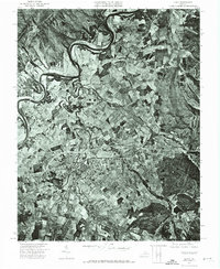 1972 Luray1974 Print · USGSPage County agriculture and the town of Luray are captured from the air during the early seventies. This orthophoto allows researchers to trace exact property boundaries, field patterns, and the dense woodlands of Massanutten Mountain.
 - 1972 Map of Strasburg, 1977 Print
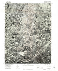
 1972 Strasburg1977 Print · USGSStrasburg and the Shenandoah Valley are captured in high-altitude detail during the early 1970s. Local researchers can trace the winding North Fork Shenandoah River as it passes Strasburg and the rural community of Waterlick.
 - 1972 Map of Middletown, 1977 Print
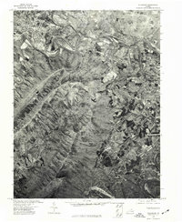
 1972 Middletown1977 Print · USGSThe Shenandoah Valley comes into sharp focus during the early seventies, showing the intersection of local agriculture and community growth. Trace the winding path of Cedar Creek and the established layouts of Middletown and Lebanon Church.
 - 1977 Map of New Market, 1983 Print
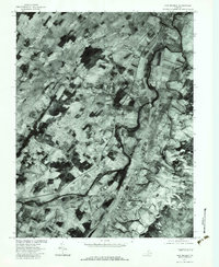 1977 New Market1983 Print · USGSThe Shenandoah Valley comes into sharp focus in the late seventies, showing the traditional farming landscape and river crossings of the era. Genealogists and local historians can trace family locations near Quicksburg, Shavertown, and the banks of Smith Creek.
End of results
Showing maps 1-4 of 4
Top cities of Shenandoah County
- Strasburg historical maps
- Woodstock historical maps
- New Market historical maps
- Mount Jackson historical maps
- Basye historical maps
- Edinburg historical maps
See more
Frequently asked questions
- What are the different types of historical maps available for Shenandoah County?
- What is the oldest map of Shenandoah County?
- Where can I purchase historical maps of Shenandoah County for my home or office?
- Where can I download high-res historical maps of Shenandoah County?
- Are there historical topographic maps available for Shenandoah County?
- Is there historical aerial imagery available for Shenandoah County?
- Where are historical maps of Shenandoah County sourced from?