1930s Maps of Tazewell County, Virginia
Explore 16 historic maps of Tazewell County from the 1930s. These maps offer a rare glimpse into what life looked like during the 1930s — showing old roads, neighborhoods, homes, and landmarks that have changed or disappeared over time.
Whether you're researching your family's past, planning a metal detecting trip, or studying how Tazewell County's landscape evolved across the 1930s, these high-resolution maps are a powerful tool for exploring the history of this region.
- Focus on a specific era: All maps on this page are from the 1930s, giving you a focused view of this time period.
- See what’s changed: Compare century-old streets, trails, and buildings to today's modern landscape using overlays and satellite layers.
- Research with precision: Use these maps for genealogy, historical research, land use analysis, or educational projects.
- View, download, or print: Maps are fully viewable online in high resolution, and can be downloaded or printed for your own records.
Start exploring Tazewell County's history through authentic maps from the 1930s. This is your window into the past.
Tazewell County, VA maps
(16)- 1934 Map of Chatham Hill
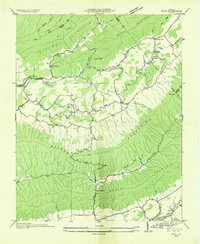
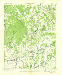
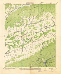 1934 Chatham Hill1934 Print · USGSSmyth County's river valleys and ridgelines are captured here in the mid-1930s during the early development of the regional park system. Researchers can locate vanished landmarks like New Cove Sch, the site of the Proposed Hungry Mother Lake, and the crossing at Ellendale Ford.
 - 1934 Map of Bandy
 1934 Bandy1934 Print · USGSThe rugged borderlands of Tazewell County and West Virginia are captured here in the mid-1930s, showing a landscape of steep ridges and remote hollows. Researchers can trace family roots through numerous local schools like Indian Creek Sch and find old burial sites at Christian Cem.
 - 1934 Map of Liberty
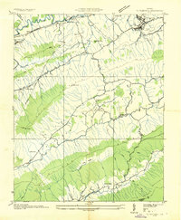
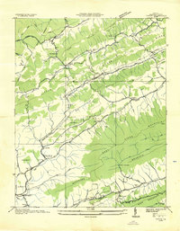
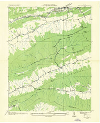
 1934 Liberty1934 Print · USGSTazewell County's Appalachian ridges were well-established by the mid-1930s, defined by coal-hauling rail lines and a network of mountain gap communities. Genealogists can trace family landmarks like Phillips Cem, Bandys Chapel, and rural schools like Raven Nest Sch and Cove Sch.
 - 1934 Map of Tazewell
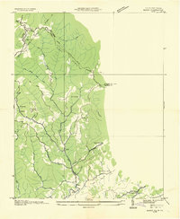
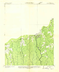
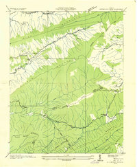
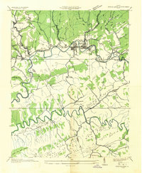
 1934 Tazewell1934 Print · USGSThe Clinch River headwaters and Appalachian ridges of Tazewell County are captured here in the mid-1930s. Researchers can trace the Norfolk and Western railroad through Maxwell or locate country landmarks like Creagers Mill and the Tazewell County Fair Grounds.
 - 1935 Map of Nebo
 1935 Nebo1935 Print · USGSSmyth County mountain valleys and the Holston River are mapped here in the mid-1930s. Genealogists can locate family landmarks like Tilson Mill, Groseclose Store, and rural schoolhouses including Nebo Sch.
 - 1935 Map of Maccrady
 1935 Maccrady1935 Print · USGSSmyth and Tazewell Counties are shown here during the mid-1930s, as industrial activity along the river defined the local economy. Researchers can trace the path of the Mathieson Alkali Works R. R. and locate family landmarks like Carter Sch or Watsons Gap Sch.
 - 1935 Map of Jewell
 1935 Jewell1935 Print · USGSThe borderlands of Buchanan and Tazewell Counties are shown in the mid-1930s as industrial development followed the mountain hollows. Researchers can trace the rail-and-ridge economy through Jewell Ridge PO, the Norfolk and Western line, and rural schools like Smith Sch.
 - 1935 Map of Tiptop
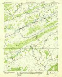
 1935 Tiptop1935 Print · USGSIn the mid-thirties, the mountainous borderlands of Tazewell County were centered on the rail corridors of the Norfolk and Western Railway. Researchers can trace the exact locations of vanished community hubs like Wittens Mills, Sluss Sch, and the Burkes Garden Siding.
 - 1935 Map of Pistol Gap
 1935 Pistol Gap1935 Print · USGSThe mountain passes of Southwest Virginia are captured in the mid-1930s as the TVA began its regional surveys. Researchers can trace early trails and family-named landmarks such as McGlothlin Hollow, Linn Spring, and Shorts Gap.
 - 1935 Map of Honaker
 1935 Honaker1935 Print · USGSThe Clinch River valley near the triple-county border of Russell, Buchanan, and Tazewell is documented here in the mid-1930s. Genealogists can locate family landmarks like Log Cabin Ch, Gardner Mill, and numerous rural schoolhouses including Barrett Sch.
 - 1935 Map of Saltville
 1935 Saltville1935 Print · USGSSouthwest Virginia's industrial heart comes into focus during the mid-thirties as the salt-and-alkali economy thrives along the Holston River. Genealogists can trace the early footprint of Tumbling Creek College or locate long-standing landmarks like Belfast Mills and the Mathieson Alkali Works R R.
 - 1935 Map of Nye Cove
 1935 Nye Cove1935 Print · USGSTazewell and Bland counties are captured here in the mid-1930s as the rail and river economy centered on the Bluestone River shaped the borderlands. Genealogists and historians can trace family locations near West Graham P O, Shawver Mill, and local landmarks like Maple Hill Cem.
 - 1935 Map of Hutchinson Rock
 1935 Hutchinson Rock1935 Print · USGSTazewell and Bland counties met along the high ridges of the Clinch Mountains during the mid-1930s. Researchers can trace early rural life through landmarks like Hutchinson Rock, the Thompson Sch, and several localized sites like Burkes Garden No 2.
 - 1935 Map of Garden Mountain
 1935 Garden Mountain1935 Print · USGSBland County highland valleys are captured in the mid-1930s as the Tennessee Valley Authority surveyed these mountain gaps. Genealogists can locate family homes and community centers near Sharon Springs, Little Town, and Red Oak Sch along the North Fork Holston River.
 - 1935 Map of Richlands
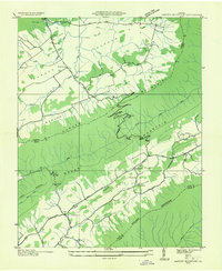
 1935 Richlands1935 Print · USGSSouthwest Virginia's industrial and mountain landscape comes alive in the mid-1930s as the Clinch River valley hums with activity. Researchers can trace the rail-side growth of Richlands and Cedar Bluff, find remote mountain schools like Red Ash Sch, and locate the Premier Coal Corporation Camp.
 - 1936 Map of Burkes Garden
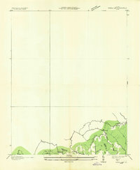
 1936 Burkes Garden1936 Print · USGSTazewell and Bland Counties appear in the mid-1930s, defined by the extraordinary limestone bowl of Burkes Garden. Genealogists and historians can trace family locations near Maple Hill Cem, the Witten Mill settlement, and the industrial corridor at Bluefield.
End of results
Showing maps 1-16 of 16
Top cities of Tazewell County
- Richlands historical maps
- Bluefield historical maps
- Tazewell historical maps
- Raven historical maps
- Claypool Hill historical maps
- Cedar Bluff historical maps
See more
Frequently asked questions
- What are the different types of historical maps available for Tazewell County?
- What is the oldest map of Tazewell County?
- Where can I purchase historical maps of Tazewell County for my home or office?
- Where can I download high-res historical maps of Tazewell County?
- Are there historical topographic maps available for Tazewell County?
- Is there historical aerial imagery available for Tazewell County?
- Where are historical maps of Tazewell County sourced from?