1940s Maps of Tazewell County, Virginia
Explore 4 historic maps of Tazewell County from the 1940s. These maps offer a rare glimpse into what life looked like during the 1940s — showing old roads, neighborhoods, homes, and landmarks that have changed or disappeared over time.
Whether you're researching your family's past, planning a metal detecting trip, or studying how Tazewell County's landscape evolved across the 1940s, these high-resolution maps are a powerful tool for exploring the history of this region.
- Focus on a specific era: All maps on this page are from the 1940s, giving you a focused view of this time period.
- See what’s changed: Compare century-old streets, trails, and buildings to today's modern landscape using overlays and satellite layers.
- Research with precision: Use these maps for genealogy, historical research, land use analysis, or educational projects.
- View, download, or print: Maps are fully viewable online in high resolution, and can be downloaded or printed for your own records.
Start exploring Tazewell County's history through authentic maps from the 1940s. This is your window into the past.
Tazewell County, VA maps
(4)- 1941 Map of Pounding Mill
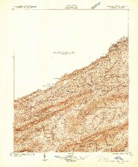 1941 Pounding Mill1941 Print · USGSThe Clinch River valley in the early 1940s shows a landscape organized by rail and ridge. Genealogists can trace family names at Maiden Spr, locate rural landmarks like Wittens Mill, or find old school sites like Linkous Sch.
 - 1941 Map of Burkes Garden
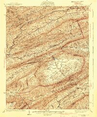 1941 Burkes Garden1941 Print · USGSTazewell County in the late nineteen-thirties reveals the distinctive enclosed valley of Burkes Garden and the rail corridors of the north. Genealogists and hikers can trace the paths to Gose Mills, rural congregations like Marys Chapel, and schools such as Redoak Sch.3 unique versions available
 - 1947 Map of Pounding Mill
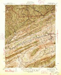 1947 Pounding Mill1947 Print · USGSTazewell County's coal and rail corridor is captured here in the mid-1940s, showing a landscape of tight mountain valleys and rural settlements. Genealogists can locate family landmarks like Witten Fort, Litz Chapel, and dozens of named schools from Bearwallow Sch to Mitchell Sch.2 unique versions available
 - 1947 Map of Richlands, 1965 Print
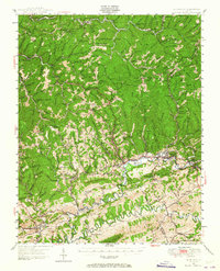 1947 Richlands1965 Print · USGSThe coal and rail corridor of Southwest Virginia comes to life in the late 1940s, centered on the busy mountain towns of Richlands and Raven. Trace ancestral homesteads and local institutions near the Richlands Airport or schools like Crystal Block School and Whitewood School.
End of results
Showing maps 1-4 of 4
Top cities of Tazewell County
- Richlands historical maps
- Bluefield historical maps
- Tazewell historical maps
- Raven historical maps
- Claypool Hill historical maps
- Cedar Bluff historical maps
See more
Frequently asked questions
- What are the different types of historical maps available for Tazewell County?
- What is the oldest map of Tazewell County?
- Where can I purchase historical maps of Tazewell County for my home or office?
- Where can I download high-res historical maps of Tazewell County?
- Are there historical topographic maps available for Tazewell County?
- Is there historical aerial imagery available for Tazewell County?
- Where are historical maps of Tazewell County sourced from?