1950s Maps of Tazewell County, Virginia
Explore 13 historic maps of Tazewell County from the 1950s. These maps offer a rare glimpse into what life looked like during the 1950s — showing old roads, neighborhoods, homes, and landmarks that have changed or disappeared over time.
Whether you're researching your family's past, planning a metal detecting trip, or studying how Tazewell County's landscape evolved across the 1950s, these high-resolution maps are a powerful tool for exploring the history of this region.
- Focus on a specific era: All maps on this page are from the 1950s, giving you a focused view of this time period.
- See what’s changed: Compare century-old streets, trails, and buildings to today's modern landscape using overlays and satellite layers.
- Research with precision: Use these maps for genealogy, historical research, land use analysis, or educational projects.
- View, download, or print: Maps are fully viewable online in high resolution, and can be downloaded or printed for your own records.
Start exploring Tazewell County's history through authentic maps from the 1950s. This is your window into the past.
Tazewell County, VA maps
(13)- 1950 Map of Richlands
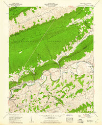
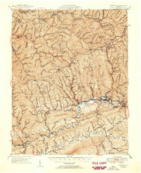 1950 Richlands1950 Print · USGSRichlands and the Clinch River valley are shown here in the late 1940s as the rail and coal industries shaped the landscape. Genealogists can trace family names through dozens of rural landmarks like Paint Lick Sch, Jewell Chapel, and the Wolfpen Ridge Cem.
 - 1953 Map of Winston-Salem, 1974 Print
 1953 Winston-Salem1974 Print · USGSThe North Carolina Piedmont and Virginia highlands meet in the mid-1950s, a landscape defined by the tobacco and textile hubs of the Blue Ridge foothills. Researchers can trace the rail-and-river geography connecting Winston-Salem to mountain towns like Mount Airy and Galax.2 unique versions available
 - 1955 Map of Bluefield
 1955 Bluefield1955 Print · USGSThe Central Appalachian borderlands come alive in the mid-fifties, showing the coal and rail networks connecting Bluefield to Beckley. Researchers can trace the industrial landscape of the New River Ordnance Plant and the terrain of Burkes Garden.
 - 1955 Map of Winston-Salem
 1955 Winston-Salem1955 Print · USGSThe Central Blue Ridge and Piedmont transition are captured here in the mid-fifties, from the industrial hub of Winston-Salem to the high peaks of Southwest Virginia. Genealogists can trace family landmarks like Richmond Hill Ch, Siloam Ch, and the old rail stops along the Southern Railway.
 - 1956 Map of Bland, 1958 Print
 1956 Bland1958 Print · USGSThe Virginia-West Virginia borderlands during the mid-fifties reveal a landscape of ridge-top trails and creek-side settlements. Researchers can trace the path of the Appalachian Trail past historic sites like Original Stony Fork Ch and Newberry Chapel.2 unique versions available
 - 1957 Map of Bluefield, 1967 Print
 1957 Bluefield1967 Print · USGSThe heart of Central Appalachia in the mid-fifties is defined by the winding rail lines and river valleys of the coalfields. Researchers can trace the industrial footprints of towns like Welch and Princeton or locate landmarks such as the Bluestone Reservoir and Claytor Lake.2 unique versions available
 - 1958 Map of Hutchinson Rock, 1960 Print
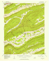
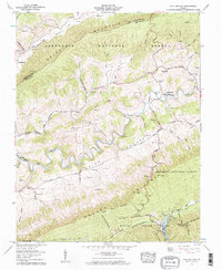
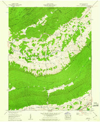
 1958 Hutchinson Rock1960 Print · USGSTazewell County's high ridges and secluded valleys are documented in the late fifties, showing the complex borderlands with Bland and Smyth counties. Trace family history at Buchanan Cem or locate rural landmarks like Hutchinson Rock and Gospel Tabernacle.3 unique versions available
 - 1958 Map of Saltville, 1960 Print
 1958 Saltville1960 Print · USGSThe industrial corridor of the Holston River meets the ridges of the Jefferson National Forest in the late fifties. Genealogists can trace dozens of family burial sites like Vencill and Settle, while historians can locate the Olin Mathieson Chemical Corp RR and R B Worthy High Sch.4 unique versions available
 - 1958 Map of Broadford, 1960 Print
 1958 Broadford1960 Print · USGSRich Valley in the late fifties is captured here as a network of river settlements and ridge-top forests along the North Fork Holston River. Genealogists can locate family landmarks like the Keister Cem, Old Broad Ford, and the Buckeye Hollow Sch before the landscape modernized.5 unique versions available
 - 1958 Map of Chatham Hill, 1960 Print
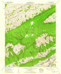
 1958 Chatham Hill1960 Print · USGSRich Valley and the Holston River corridor are captured here during the late fifties, showing a rural landscape defined by ridge-and-valley farming. Genealogists can locate family sites at Tannersville Cem, Chatham Hill Cem, and numerous hillside burials like the Thompson Cem.2 unique versions available
 - 1958 Map of Tiptop, 1960 Print
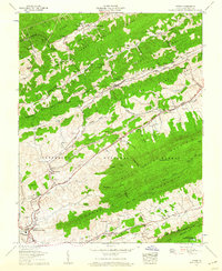 1958 Tiptop1960 Print · USGSTazewell County's mountain valleys were a hub of rail transit and coal mining during the late fifties. Genealogists and historians can trace family burial sites like Witten Cem and Peery Cem or locate industrial sites such as Wittens Mills and the Prison Camp No 31.3 unique versions available
 - 1958 Map of Garden Mountain, 1960 Print
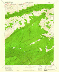
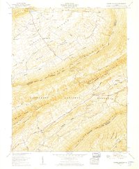 1958 Garden Mountain1960 Print · USGSIn the late fifties, the secluded mountain bowl of Burkes Garden remained a pocket of deep rural history on the Tazewell and Bland county lines. Researchers can trace ancestral sites like Thompson Cem, the old Gose Mill, and the path of the Appalachian Trail through the high country.4 unique versions available
 - 1959 Map of Nebo, 1960 Print
 1959 Nebo1960 Print · USGSSmyth County was a landscape of remote mountain ridges and tightly knit valley communities at the end of the fifties. Genealogists can trace family names through numerous remote burial sites and churches like Hubble Cem, Young Chapel, and Nebo.4 unique versions available
End of results
Showing maps 1-13 of 13
Top cities of Tazewell County
- Richlands historical maps
- Bluefield historical maps
- Tazewell historical maps
- Raven historical maps
- Claypool Hill historical maps
- Cedar Bluff historical maps
See more
Frequently asked questions
- What are the different types of historical maps available for Tazewell County?
- What is the oldest map of Tazewell County?
- Where can I purchase historical maps of Tazewell County for my home or office?
- Where can I download high-res historical maps of Tazewell County?
- Are there historical topographic maps available for Tazewell County?
- Is there historical aerial imagery available for Tazewell County?
- Where are historical maps of Tazewell County sourced from?